Download
1 / 5
50 likes | 55 Views
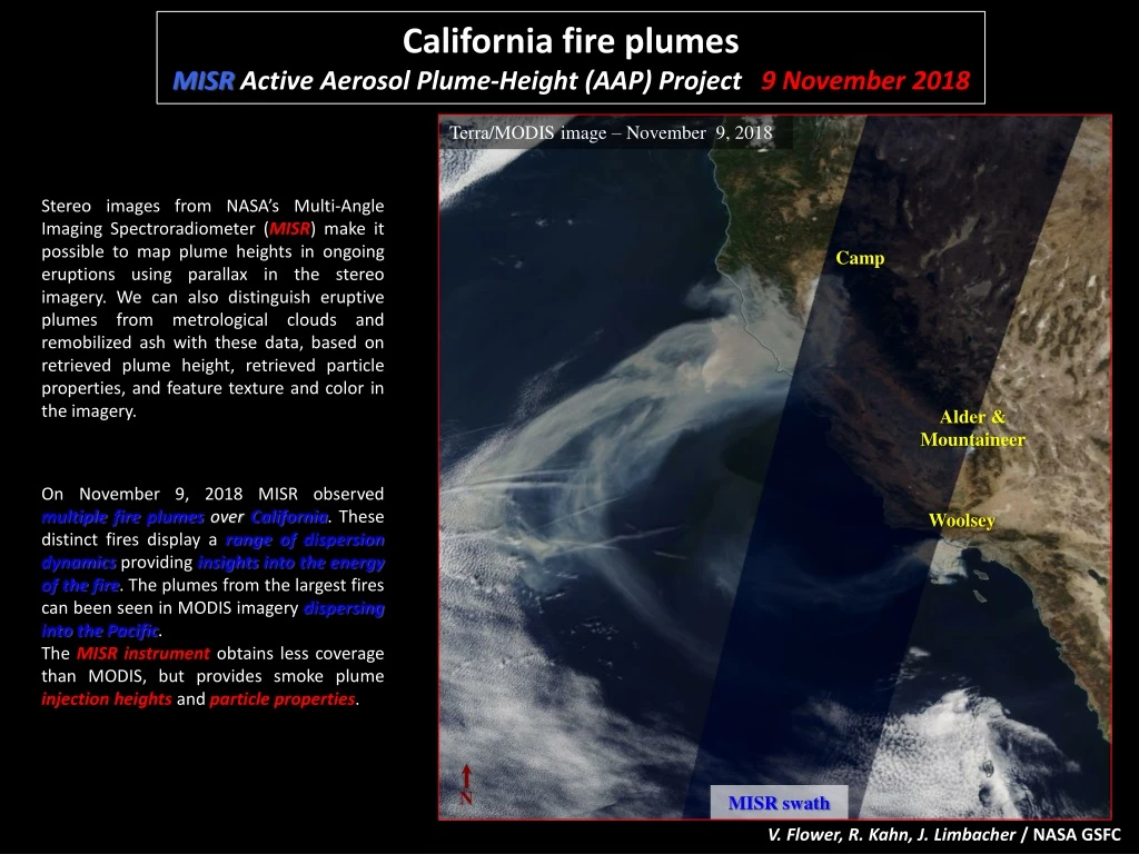
California fire plumes MISR Active Aerosol Plume-Height (AAP) Project 9 November 2018. Terra/MODIS image – November 9, 2018.

E N D
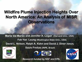
California fire plumes MISRActive Aerosol Plume-Height (AAP) Project 9 November 2018 Terra/MODIS image – November 9, 2018 Stereo images from NASA’s Multi-Angle Imaging Spectroradiometer (MISR) make it possible to map plume heights in ongoing eruptions using parallax in the stereo imagery. We can also distinguish eruptive plumes from metrological clouds and remobilized ash with these data, based on retrieved plume height, retrieved particle properties, and feature texture and color in the imagery. Camp Alder & Mountaineer On November 9, 2018 MISR observed multiple fire plumes overCalifornia. These distinct fires display a range of dispersion dynamics providing insights into the energy of the fire. The plumes from the largest fires can been seen in MODIS imagery dispersing into the Pacific. The MISR instrument obtains less coverage than MODIS, but provides smoke plume injection heights and particle properties. Woolsey N MISR swath V. Flower, R. Kahn, J. Limbacher /NASA GSFC
California fire plumes – The Camp Fire MISRActive Aerosol Plume-Height (AAP) Project 9 November 2018 CAMP FIRE Origin: November 8, 2018 ~39.81N, -121.44W MISR plume-height map The Camp fire was the northernmost California fire MISR imaged on Nov. 9, and it was the deadliest fire in state history. It lofted smoke 2-3 km above the terrain, and some was transported over 300 km downwind. It is likely that the fires were sufficiently energetic to inject the smoke above the stable near-surface atmospheric boundary layer into the free troposphere. The plume descended to ~1 km as it moved south and west and approached the ocean. MISR plume-height profile Red = zero-wind height Blue = wind-corrected height Green= surface elevation MISR/MINX plume region V. Flower, R. Kahn, J. Limbacher /NASA GSFC
California fire plumes – The Alder & Mountaineer Fires MISRActive Aerosol Plume-Height (AAP) Project 9 November 2018 ALDER & MOUNTAINEER FIRES Origin: October 4, 2018 ~ 36.22N, -118.62W The Alder & Mountaineer fires injected smoke up to ~3-4 km ASL on Nov. 9, but this is much nearer the surface in this mountainous terrain. The relatively constant elevation and lack of apparent particle settling suggest this plume is concentrated in a layer of atmospheric relative stability above the near-surface boundary layer. MISR plume-height map MISR/MINX plume region Red = zero-wind height Blue = wind-corrected height Green= surface elevation V. Flower, R. Kahn, J. Limbacher /NASA GSFC
California fire plumes – The Woolsey Fire MISRActive Aerosol Plume-Height (AAP) Project 9 November 2018 WOOLSEY FIRE Origin: November 8, 2018 ~36.22N, -118.62W MISR/MINX plume region For the Woolsey fire in southern California, initial injection occurred at ~3 km ASL on November 09. The densest sections of the plume extend ~100 km downwind before descending to ~1 km and becoming more diffuse. Satellite plume height maps, when available, can be used to constrain air quality forecasting models. Red = zero-wind height Blue = wind-corrected height Green= surface elevation MISR plume-height map V. Flower, R. Kahn, J. Limbacher /NASA GSFC
California fire plumes – Smoke Particle Properties MISRActive Aerosol Plume-Height (AAP) Project 9 November 2018 • MISR Research Algorithm (RA) – Aerosol Amount and Type Retrievals B A • The MISR Research Aerosol (RA) retrieval algorithm produces (A) aerosol amount (optical depth – AOD), (B) an aerosol size constraint (Angstrom Exponent) (C) fraction of non-spherical particles, and (D) particle light-absorption (SSA). Near the Camp fire source region the particles tend to be large (low Angstrom Exponent) and non-spherical particles, probably from burning in the town of Paradise. Aerosols are smaller and more spherical downwind, probably as the plume mixes with smoke from burning forest. • The Alder and Mountaineers plume-height analysis, which relies on pixel-level contrast elements in the imagery, tracked the plume for only 50 km. However, the MISR RA, more sensitive to thin aerosol layers, observes theplume extending to the Pacific ocean. This result highlights the possible influence of plumeseven when particle concentrations render them sub-visible. • The southernmost Woolsey fire displays similarities to the Camp fire with near source regions containing larger particles. This area also contained a significant fraction of non-spherical particles (~40%), though at a lower concentration than the Camp fire (70%). The shift in particles from large, non-spherical to small, spherical characteristics suggests that the bigger particles are settling to the surface, and it corresponds to the decrease in plume altitude. Camp Mountaineer & Alder Woolsey C D V. Flower, R. Kahn, J. Limbacher /NASA GSFC