Download

1 / 1
10 likes | 19 Views
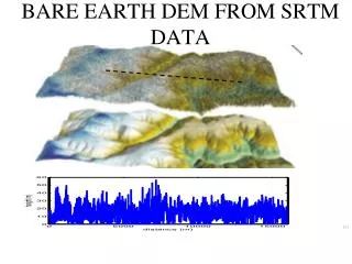
Zero Real data. Std_surface = 0.03 deg. Using Altimetry Waveform Data and Ancillary Information from SRTM and LANDSAT to retrieve River Characteristics By Vivien ENJOLRAS 1) * and Ernesto RODRIGUEZ (2) (1) CNES/LEGOS, 18, av. Edouard Belin, 31400 Toulouse, France

E N D
Zero Real data Std_surface = 0.03 deg Using Altimetry Waveform Data and Ancillary Information from SRTM and LANDSAT to retrieve River Characteristics By Vivien ENJOLRAS1)* and Ernesto RODRIGUEZ(2) (1) CNES/LEGOS, 18, av. Edouard Belin, 31400 Toulouse, France (2) Jet Propulsion Laboratory, 4800 Oak Grove Drive, Pasadena CA 91109, United States *Author to whom correspondence should be addressed - Email: vivien.enjolras@gmail.com Main Philosophy Preliminary Scene File Creation Abstract Spaceborne radar altimeters are shown to have the potential for monitoring the height of large rivers with accuracies of approximately 1 m. However, the need for a better height accuracy and the observations of smaller continental basins have led to studies on how to improve and extend the use of nadir altimeter data. Conventional retracking techniques over land are limited to the examination of altimeter waveforms on a case by case basis. Due to the arbitrary geometry which may be present at altimeter river crossings, this approach may be limited to large rivers, which approximate ocean crossings. To overcome this limitation, we introduce a waveform fitting method which uses the entire set of waveforms associated with a water crossing, rather than individual waveforms. By using ancillary data, such as a digital elevation model (obtained from SRTM, gtopo30) and classification maps (obtained from Landsat, Modis), it is possible to recast the retracking problems as a maximum likelihood estimation problem. Theoretical power returns based on the a priori knowledge of the observed scenes are generated resulting in a parametric library of waveform histories, which is then used to constrain the estimation. For demonstration, we concentrate on the river Meuse in Northern Western Europe, and on the river Lena in Russia. The Meuse has important social impact, since it has flooded in the past and better real time predictions of its changing stage may improve flood forecasting skill. Furthermore, it presents a challenge to conventional nadir altimeter waveform retracking. We will present both theoretical performance results and demonstrate the feasibility based on real altimeter data. Keywords: altimetry, waveform, hydrology, Europe • Current Methods can be qualified of Single Waveform Processing: • Waveforms classification (11 classes on ENVISAT) with specific algorithms of estimation • Method of estimation by deconvolution • Neuronal network • We on the contrary consider using the whole waveform history over continental water areas (more information) • Use of ancillary data (information added): • Optic for scene masks: LANDSAT, MODIS • Topography: SRTM, Gtopo30 Estimation Process Theory Developed Program Chart • Simulated Power Returns are function of time, instrument parameters (wavelength, power, antenna pattern, point target response χ), the satellite motion (range, incidence), and the observed scene (backscattering coefficient), as followed: • Pulse compression and onboard digital sampling of the returned signals at the frequency 1/T are equivalent to measure the time history of the return in a sequence of range gates separated by an effective two-way travel time resolution of 1/B, or a range resolution of c/(2B) (47 cm for Topex) • A template corresponds to a specific set of values for the parameters willing to be estimated: • Elevation of inland water above its a priori reference resulting from ancillary data • Backscattering coefficient, standard deviation of small gravity-capillary waves • River slope, etc… • Numerous templates with stepped sets of related scene parameters values can be generated • A MAP search is performed to find the set of parameters values resulting in the closest template to the real data • Assuming that the performed search has found a best template, close enough to the observed waveform history, its difference with the real data can finally be considered as linear in the parameters to be estimated. Considering the elevation and the backscattering coefficient to be estimated: • The derivatives can be computed for the best template set of values, and enables then to estimate the parameters with a maximum likelihood process Theoretical Validation of the Method and the Machine Example of Results on rivers Lena and Meuse • Three theoretical scenes, for different purposes, have been considered: • Ocean-like scene (validation of the power returns simulation) • Very Bright Scene Crossing (validation of the scene generation and the power returns simulation) • Two rivers whose separate distance, own height and own backscattering coefficient can be modified (Study of the parameters correlation) • In the third study, the derivatives are calculated, and the covariance matrix of the parameters then informs on their correlations • On narrow continental water areas, water templates generation is fast, but land is slower. The short ground track motion between each cycle (maximum 1 km on T/P) prevents from running land returns each time, as illustrated by the following correlation matrix of land returns for T/P cycles 380, 381, 384, 385 and 386 over Meuse: Conclusions and Perspectives 1,25 m above ancillary data basis Mean 20 days in situ data around same day in 2005: 1.2 m above basis • Theoretical Results support the new hopes offered by such a method: parameters correlation are low which shows that this 2D approach enables to distinguish narrow and close inland waters • First Results over Meuse and Lena are very convincing and favour the continuity of such a study at higher processing scales • Topex Waveforms are very peaky on Meuse and Lena, showing a very specular behaviour. The model of backscattering coefficient may need to be improved and detailed to get closer to real data in simulations • One year data is about to be processed over the Lena using MODIS data (masks computed by Dr. Larry Smith Team in University of California, Los Angeles) to get accurate evolving water masks Real Altimetry Data Processed • Topex data have been firstly selected as the tracker behavior on Topex is much smoother than on Poseidon2, resulting in a lot more data on inland waters • Topex SDR (Sensor Data Record): • 10 Hz Ku-band waveforms (64 range gates) • 20 Hz Range Ku: tracker behavior • 20 Hz AGC: automatic gain control behavior (power onboard attenuation) • 1 Hz latitude and longitude • Topex GDR (Geophysical Data Record): • 10 Hz satellite altitude above reference ellipsoid • 1 Hz flag • 1 Hz dry troposphere correction References Berry P. A. M.; Garlick, J. D.; Freeman, J. A.; Mathers, E. L. Global inland water monitoring from multi-mission altimetry. Geophysical Research Letters2005, 32. Birkett, C.M.; Mertes, L.A.K; Dunne, T.; Costa, M.; Jasinski, J. Altimetric remote sending on the Amazon: Application of satellite radar altimetry. J. Geophysic. Res. 2002, 107 (D20), 8059, 10.1029. Chelton, D. B.; Walsh, E.J.; MacArthur, J. L. Pulse compression and sea level tracking in satellite altimetry. J. Atmos. Oceanic Technol.1989, 6, 407-438. Frappart, F.; Calmant, S.; Cauhope, M.; Seyler, F.; Cazenave, A. Preliminary results of ENVISAT RA-2-derived water levels validation over the Amazon basin. Remote Sensing of Environment 2006, 100, 252-264. Rodriguez, E.; Chapman, B. Extracting ocean surface information from altimeter returns: the deconvolution method. J. Geophysic. Res. 1989, 94 (C7), 9, 761-9, 778. 15 Years of Altimetry, Venice, March 2006