Download
1 / 28
290 likes | 475 Views
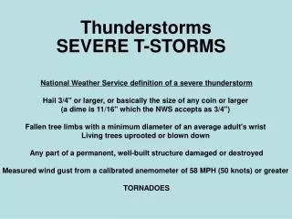
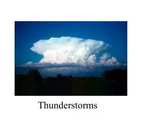
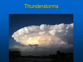
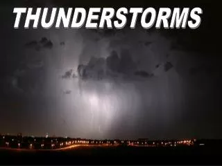
Thunderstorms. Ordinary Cell Thunderstorms. cumulus stage mature stage dissipating stage. Ordinary cell thunderstorms are sometimes called ‘air mass thunderstorms’, because they form in conditionally unstable air masses and are not necessarily associated with fronts or severe weather.

E N D
Ordinary Cell Thunderstorms • cumulus stage • mature stage • dissipating stage • Ordinary cell thunderstorms are sometimes called‘air mass thunderstorms’, because they form in conditionally unstable air masses and are not necessarily associated with fronts or severe weather.
Ordinary thunderstorms tend to form in regions of limited wind shear. Form along shallow zones where surface winds converge: topographic irregularities, sea-breeze fronts, outflow boundaries from thunderstorms… producing more thunderstorms. Converging wind boundaries are regions of temperature and humidity contrasts: density differences.
Life cycle of an ordinary thunderstorm Mature stage Dissipating stage Cumulus stage Fig. 10-1, p. 265
Cumulus stage: Is the growth stage, as cumulus cloud builds, transformation of water vapor to liquid and solid cloud droplets releases latent heat that keeps the rising air inside the cloud warmer than environment. During this stage there is insufficient time for precipitation to form. Updrafts keep water droplets and ice crystals suspended within the cloud There is no lightning or thunder during this stage The building cumulus takes on the appearance of a ‘tower’
Mature stage: As the cloud builds above the freezing level, the cloud droplets grow larger and heavier. Eventually the rising air can no longer keep the particles suspended and they begin to fall. Drier air around the cloud begins to be drawn into the cloud in a processes know as entrainment. The entrainment of drier air into the cloud causes some of the raindrops to evaporate, which cools the air. The air now colder begins to descend as a downdraft. The appearance of the downdraft marks the beginning of the mature stage.
Mature stage: The updraft and downdraft within the mature thunderstorm now constitute the cell. During the mature stage, the thunderstorm is most intense. The top of the cloud, having reached a stable region of the atmosphere, begins to take on the anvil shape as upper-level winds spread the cloud’s ice crystals horizontally. Updrafts and downdrafts are at their greatest strength in the middle of the cloud, creating severe turbulence. Lightning and thunder are also present in the mature stage.
Mature stage: Heavy rain falls from the cloud, and at the surface there is a downrush of cold air with the onset of precipitation. Where the cold downdraft reaches the surface, the air spreads out horizontally in all directions. The boundary between the cold air and the warm surface air is called a gust front. The storm begins to dissipate after 15-30 minutes after entering the mature stage.
Dissipating stage: Occurs when the updrafts weaken as the gust front moves away from the storm and no longer enhances the updrafts. At this stage, downdrafts dominate throughout much of the cloud. The reason the storm does not last very long is that the downdrafts inside the cloud tend to cut off the storm’s fuel supply by destroying the humid updrafts. Not only do thunderstorms produce summer rainfall for a large portion of the US, but they also provide momentary cooling after an oppressively hot day.
Life cycle of an ordinary thunderstorm Mature stage Dissipating stage Cumulus stage Fig. 10-1, p. 265
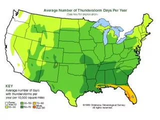
The average number of days each year on which thunderstorms are observed throughout the United States Fig. 10-18, p. 277
Severe Thunderstorms and the Supercell • multicell storms • supercell
Severe Thunderstorms The likelihood that a thunderstorm will become severe increases with the length of time the storm survives. Ordinary thunderstorms tend to from in regions of low wind shear. Because of this, the storms downdraft and precipitation can fall into the updraft– which kills the storm. If there is some moderate wind shear, the precip is pushed downwind so that it does not fall into the updraft– and thus the updraft is not suppressed. If the downdraft undercuts the updraft, then new cells can form, producing a long-lasting multicell storm. A storm with a cluster of cells at various stages of their life cycles.
Radar image of an outflow boundary Fig. 10-13, p. 272
Severe Thunderstorms In a multicell storm, if convection is strong and updrafts intense, the storm can become severe. Updrafts in severe thunderstorms can cause the cloud to reach into the stratosphere and in some cases extend up to 60,000 ft. Strong updrafts can keep hailstones suspended in the cloud long enough for them to grow to considerable size. Once they become large enough they either fall out the bottom of the cloud within a downdraft or a strong updraft may toss them out the side. Aircraft have encountered hail in clear air several kilometers away from a storm.
Supercell thunderstorm When winds become stronger aloft, the wind shear may be strong enough to create horizontal spin, which when tilted into the updraft causes it to rotate. In this case, the thunderstorm may grow into a larger, long-lasting (longer than an hour), severe storm called a Supercell. The rotational aspect of supercells can lead to the formation of tornadoes. Supercell storms are typically enormous thunderstorms that consist of primarily of a single violently rotating updraft.
Conditions leading to the formation of severe thunderstorms, and especially supercells
A wall cloud associated with a supercell thunderstorm spins counterclockwise
A supercell thunderstorm with a tornado sweeps over Texas Fig. 10-4, p. 268
Squall Line A squall line forms as a line of thunderstorms, either right along a cold front or in the warm air 100-300 km ahead of it. Pre-frontal squall-line thunderstorms represent the most severe and largest type of squall lines. There is still debate as to exactly how pre-frontal squall lines form.
A Doppler radar composite showing a pre-frontal squall line extending from Indiana southwestward into Arkansas
Pre-frontal squall-line Pre-frontal squall-line thunderstorms may form ahead of an advancing cold front as the upper-air flow develops waves downwind from the cold front.
Mesoscale Convective Complexes Mesoscale Convective Complexes (MCCs) form when a number of thunderstorms grow into a single, large, circular convective weather system. They can be as large as 1000 times that of a ordinary cell thunderstorm. Can cover an entire state and move slowly lasting up to 12 hours Form during summer in regions where upper-level winds are weak. Are associated with severe weather, including hail, high winds, destructive flash floods, and tornadoes.
A simplified model describing air motions and other features associated with an intense thunderstorm that has a tilted updraft. Fig. 10-10, p. 271
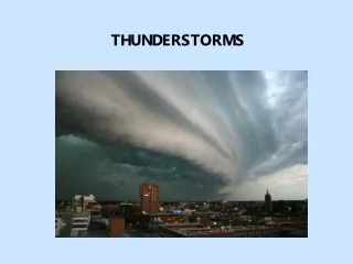
A dramatic example of a shelf cloud (or arcus cloud) associated with an intense thunderstorm Fig. 10-11, p. 271
Summary of today’s lecture Life cycle of ordinary thunderstorms Multicell thunderstorms Severe thunderstorms Squall lines Supercell thunderstorms Mesoscale Convective Complexes.