Download
1 / 15
150 likes | 248 Views
Image acquisition in the NPS. What do we have? How can we get it ? How can we get more? What else is happening?. Outline. RSIC (Remote sensing Image Catalog) Other sources for imagery RS update. RSIC. Remote Sensing Image Catalog Landsat TM imagery from MRLC NAIP DOQQs

E N D
Image acquisition in the NPS • What do we have? • How can we get it ? • How can we get more? • What else is happening?
Outline • RSIC (Remote sensing Image Catalog) • Other sources for imagery • RS update
RSIC • Remote Sensing Image Catalog • Landsat TM imagery from MRLC • NAIP DOQQs • Collect, hold and distribute to Park units, Networks and Regions
Landsat TM • From the MRLC archive • Pre processed • At sensor reflectance • Geometric registration • >4200 Landsat TM scenes • More on the way from MRLC 2006 • Potential for 30 yr history. • Landsat 4,5 and 7
NAIP DOQQs • National Agricultural Image Program • DOQQs (1 meter pixels) • CCM (1 and 2 meter pixels) • Differences in image quality and file size • “unique” labeling system • Currently over 8 TB of imagery • More on order • NR GIS creating park mosaics
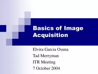
USGS Quad-numbering Schemes Example shown for 1-degree block “36104”
Additional sources of imagery • NGA CRSSP archive • LandFire archive (http://www.landfire.gov) • Univ of MD archive • USGS archive of historic imagery • Aerial photo summary record system • USFS • BLM
New Imagery • Aerial Photography • USGS CRSC • Contract specs for use • High Res Commercial • NGA • USGS CRSC • NPS contracting/purchasing
Other products from NLCD • NLCD National Land Cover Data • 1992 • 2001 • 2006 • Change • Impervious surface • Canopy cover • Website http://www.mrlc.gov/mrlc2k_nlcd.asp
New info • Imagery for America • Landsat Data Continuity Mission (LDCM) • National Land Imaging Program (NLIP) • NAIP 2008 states • LiDAR for the Nation? • More free Landsat (http://glovis.usgs.gov/) • L7 by Sept • L5 by Dec • UTM projection, at sensor calibration
Other news • NPS RS SC (Dave Duran, Mike Story) • Web site (http://www.nps.gov/gis/remote_sensing/index.html) • DOI RSWG • Conferences • USFS RS2008 • ASPRS Annual Conference • PECORA
Questionnaire • Please take one, fill it out and return it • Need info in order to meet your needs
Thanks • For questions or more info: • Mike Story (303)969-2746 • Thom Curdts (303)987-6950