Download
1 / 37
370 likes | 377 Views
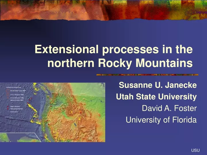
Extensional processes in the northern Rocky Mountains. Susanne U. Janecke Utah State University David A. Foster University of Florida. Extensional processes in northern Rockies This talk: Selective overview of evolution of this province A few questions about the province.

E N D
Extensional processes in the northern Rocky Mountains Susanne U. Janecke Utah State University David A. Foster University of Florida USU
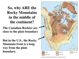
Extensional processes in northern Rockies This talk: Selective overview of evolution of this province A few questions about the province forgotten part of the Basin-and-Range north of San Andreas MTJ USU Sonder and Jones, 1999
Long history of extension: • Belt basin • Passive margin • Sevier orogeny? • Eocene core complexes • Many younger phases of extension- • Too many to name • Extension continues today Sonder and Jones, 1999 USU
Cenozoic extension is superimposed on: • Belt basin • Paleozoic hingeline • West edge of continental crust • Fold-and-thrust belt • Lewis and Clark line • Idaho batholith • Laramide foreland province Mitra (1997) USU
Thrust belt-mostly NW strikes near ESRP • Thrust belt has salients and reentrants- • Culminations • Note bend in thrust south of ESRP • Laramide province has diverse trends: • NE NW E N USU
Overall curvature of the normal faults parallels the fold-and-thrust belt • Strikes of normal faults changes south of ESRP • Largest faults collapsed culminations Modified from Carney and Janecke, 2005 GSAB USU
Parallel strikes are a bit puzzling • Western part has normal faults that clearly CUT the thrusts • Lost River fault-planar to ~15 km depth • Wasatch fault • Yet strikes of those normal faults grossly parallel the thrust belt • Eastern part of thrust belt shows much simple “backsliding” on thrusts • Model of West (1992, 1993) explains this pattern USU
MGF Seismic data reveal reactivated thrust faults in the east • Older Grasshopper thrust fault guided the extension • Ramps and flats in Muddy-Grasshopper detachment fault- • Inherited? • Shallow depth of faults :1.5 to 2.5 sec Grasshopper basin USU seismic line ML-83-01
Predictions of geologic data • Depths of normal faults in thrust belt should increase westward • Will we see this in locking depths? • Extension directions would be • dip-slip if bouyancy from thrust belt drives normal faulting • Oblique-slip if some other process dominate • Test with • GPS campaigns • Focal mechanisms • Slickenline data USU
Metamorphic core complexes: Oldest widespread extension: • Late Paleocene to Eocene-narrow belt • Mostly top ENE to top ESE slip (some top west slip too) • Less extension in the south? • Several pairs of complexes-even triplets • Bivergent slip Figure from Foster et al. in press. 200 km USU
Large magnitude of Eocene extension north of 45° N • 30-40 km of displacement across Anaconda MCC • 45-50 km across Bitterroot MCC Foster et al. in press. USU Figure from Foster et al. in press.
Figure from Foster et al. in press. 200 km Lewis and Clark line: Transfer fault within the northern Rockies Left step and left bend of core complexes (Foster et al., in press.) >300 km step Clearwater core complexes lies within the stepover zone USU
Lewis and Clark line: Many unknowns • Does it cut across Precambrian crustal boundaries? • Why did it have such a profound effect? • From Belt time to mid Tertiary? • Depth extent? Geometry? • Still active? • Modern strain profile Figure from Foster et al. in press. This feature has partitioned strain for ~1.5 Ga. Why? USU
Core complexes were just the first of many periods of extension: Robust extension continued into early Miocene • Eocene to Oligocene (± e. Mio.) basin-forming event • Paleogene rift zone-narrow • Moderate displacement • Detachment faults • Sedimentary basins formed-supradetachment basins • Two major accommodation zones-one at Lewis and Clark line • Quiescent Renova basin east of the rift zone (debated) • Core complexes (pink) • Remnants of sedimentary basins-pale orange A B A Modified from Janecke (1994)
Complex fault systems reflect changing strain field 10 km Tendoy Mountains Beaverhead Range Janecke et al., 2000 USGS OF USU Pre-Eocene to Recent normal faults
Many changes in extension direction over time • Extension direction can change dramatically (up to 90°) • in short periods of time. • Many changes can occur • up to 6 temporally and geometrically distinct sets of normal faults • Largest normal faults parallel the thrust belt • Geodynamic models should consider such variability USU VanDenburg et al., 1998
Altogether Basin and Range faults-4 domains? • Idaho batholith • little extension • Former fold-and-thrust belt • regular spacing and moderate extension • long fault systems • N to NW strikes • Laramide foreland • Many trends • Shorter faults • Anomalous trends near the Yellowstone hot spot and its former positions? USU Modified from Carney and Janecke, 2005 GSAB
Few normal faults cut the Idaho batholith: • Strong crust and lack of preexisting thrusts probably explain this pattern • Is this strain pattern evidence in GPS data sets? • Do adjacent areas compensate for this slip deficit? • e.g. Western Snake River Plain? Gentle tilts suggest modest extension there but crustal geophysics is needed IB WSRP ESRP USU
Normal faults in the former fold-and-thrust belt: • Many long fault zones: • Lost River,Lemhi and Beaverhead faults- 140-150 km long • Grand Valley-140 km • Mission fault- 102 km long • Swan fault- 156 km long • (Haller et al. Quat flts 2004) USU
Normal faults in Laramide province Short faults Gallatin Range-27 km Emigrant-43 km Bridger 48 km Tobacco Root fault-32 km Madison- 99 km Ruby Range fault-38 km Data of Haller et al. 2004 USU Modified from Carney and Janecke, 2005 GSAB
Anomalous trends of normal faults near Yellowstone • Centennial Range • north dipping fault • South-dipping rocks • Teton Range- • ESE-dipping fault • WNW-dipping rocks • Together they define a SW plunging syncline • These faults are cross faults USU Modified from Carney and Janecke, 2005 GSAB
Possible effects of Yellowstone hotspot on extension Susanne Janecke Robert Smith Michael Perkins 2000 GSA abstract USU
Cross faults: Numerous normal faults at a high angle to the overall structural grain are localized near ESRP USU
Focal mechanisms document anomalous orientation of stress near Yellowstone Waite and Smith (2004) suggest that the N-S extension may be related to viscoelastic relaxation in the upper mantle and lower crust following the 1959 Hebgen Lake earthquake. Stress map of Waite and Smith, 2004 USU
Eastern Snake River Plain is a broad SW-plunging syncline (Kirkham, 1931; Myers and Hamilton 1964, Hamilton and Myers, 1966; McQuarrie and Rodgers, 1998) Active faults adjacent to Yellowstone have anomalous trends and probably formed due to subsidence toward the Plain (Honkala, 1960; Hamilton and Myers, 1966). Minimum principal stress is perturbed adjacent to the hot spot e.g Waite and Smith, 2004 A mafic sill underlies much of the ESRP (Sparlin et al., 1982) Differential subsidence is greatest SW of the hot spot (Smith and Braile, 1993) Ancient cross faults occur throughout the region adjacent to the ESRP. Strikes of cross faults are E-W north of the plain and NNE to E-W south of the plain. Prior work and new data USU
SWward subsidence SW of Yellowstone Subsidence toward the axis of the ESRP Two components of subsidence can produce cross faults near ESRP • Component 1 + Component 2 = south dips on the NW side of the ESRP and WNW-dips on the SE side of the ESRP. USU
Testable predictions of the model 1) Teton and Centennial faults initiated in Pliocene-Quaternary time 2) Cross faults initiate earlier in the SW than in the NE • Teton area should have ESE extension • Anomalous strain field is localized near Yellowstone • Anomalous strain field should be persistent USU
Northward termination of the Basin-and-Range province Clockwise rotation? Subdomains of strain? What happens across and in the ESRP? GPS and more focal mechanisms could address these questions USU Sonder and Jones, 1999
Simple predictions of geologic history • Crust should be thinner • near MCC’s • beneath intermontane seismic belt • probably E and W of Idaho batholith • Crust should be thicker in Great Basin- • Fewer double and triple core complexes • Extension began later there USU
37 km next to ESRP (Peng and Humphreys, 1998) 38 km at Hebgen lake Nishimura Thatcher (2003) BUT Normal rifts are 30.5 km thick (Christiansen and Mooney, 1995 Some of northern Great Basin is much thinner, <30 km (Gilbert and Sheehan, 2004) Thin crust trends E-W there, not N-S Instead crust seems thick in Rocky Mtns Col. Pl. Gilbert and Sheehan, 2004 JGR Was the crust inflated by magmatism? Was the crust thicker initially? USU
Rivers flowed from highly extended core complexes to less extended areas in the Eocene-Oligocene • Arkoses are persistent feature • Base to top of Medicine Lodge beds • Even in the Everson Creek beds • Source was a 80-70 Ma granite • Two micas-both biotite and muscovite • Late Cretaceous to Early Tertiary cooling • Chief Joseph pluton in footwall of the Anaconda MCC? (Thomas , 1995) • Persistent north to south fluvial system along axis of the rift • Janecke et al. 2005 Bach Mtn map USU
Partial solution:Lower crustal flow toward core complexes? (e.g. Vanderhaeghe et al.) Away from Eastern Snake River Plain? (McQuarrie and Rodgers, 1998 Campbell and John, 2003 USU
Earthscope facility can help with these problems: • Moho mapping across the region • Strain patterns • How does hotspot influence the stress and strain field? • What drives extension now? In the past? • Recovery and rescue of industry seismic data • Comparison of GPS and geologic strain rates • Rotation and strike slip in the Basin and Range province • Deformation within the ESRP • Role of crustal inheritance USU
Break up fault Muddy-Grasshopper detachment 81-4 Our community should rescue existing industry seismic data • A wealth of data already exists • Archive in GEON or IRIS? Nicholia Creek basin SW NE 1 sec 2 sec USU