Download
1 / 19
190 likes | 325 Views
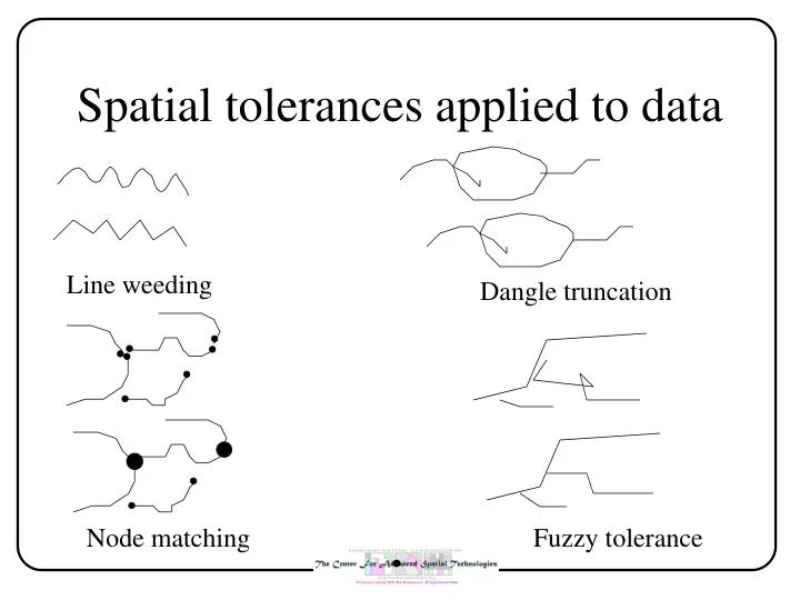
Spatial tolerances applied to data. Line weeding. Dangle truncation. Node matching. Fuzzy tolerance. Simple polygon. single unit of space bounded by three (or more) lines and containing no holes this is essentially the same definition as the cell

E N D
Spatial tolerances applied to data Line weeding Dangle truncation Node matching Fuzzy tolerance
Simple polygon • single unit of space bounded by three (or more) lines and containing no holes • this is essentially the same definition as the cell • boundary can be irregular or regular (e.g. a square can be a polygon)
Complex polygon and regions • a complex polygon is a simple polygon with one (or more holes) • can be called an area • a region is composed of two or more non-connecting simple polygons (often a scale issue) • Note - in GeoMedia this is called discontinuous geometries • examples • hole = Farmer Browns field with a pond in the center • region/discontinuous geometry = the state of Hawaii, USA • note that region usually has a different definition
Concept of contiguity and scale • example - boundaries that include water Congressional district 1 2 3 4 5 6 What is the “entity” ? The state of Hawaii? the islands of the state of Hawaii? Is the “water” part of the congressional district?
Contiguity has effect on how spatial data is stored • if unit is Hawaii • store all geometries as a single entity that is discontinuous • if unit is “islands of Hawaii” • store as multiple records • example of problem : how do you calculate the area of Hawaii
Basic statistical unit • the smallest unit for which attribute data of a given kind are collected • the basic statistical unit may be a simple/complex polygon or it may be a region • examples - the Census block and the soils mapping unit 1 Ab 2 3 Vn Vn Two “BSUs” Ab Three “BSUs”
The relationship between basic attribute unit and basic map unit • attributes may be recorded for the what are simple polygons or may be regions • if there are regions then there can lead to complexity in analyses • each polygon (simple or complex) may be unique • multiple polygons refer to a single row in the table
1 Ab 2 3 Vn Vn Ab One to one & one to many Block population Avg. income 1 12,345 $4,500 2 4,234 $10,345 3 18,900 $24,560 Soil map permeability pH unit Ab 3.6 6.7 Vn 4.8 7.2
There is not always a one to one relationships between topology and BSUs
Property of containment • inclusion of one spatial entity within another • points may be within areas • and possibly within lines depending on definition • lines may be within areas • and possibly within (or coincident with) lines • areas may be within areas • containment can be ordered • completely (proper subset) • USA - states - counties • partially • USA - states - Census MSA (may overlap multiple counties)
Determining the structure of containment may be messy • many phenomena have overlapping boundaries store shopping boundaries Store 1 Store 2 Store 3 Are there three entities or seven are there three rows in the attribute table or seven?
As multiple units are combined • largest common spatial unit resulting from the overlap • smallest units (cells) used to create the largest common unit • spatial primitives used to make up the smallest units (vertices, lines) • spatial unit for which data is recorded