Download
1 / 9
90 likes | 231 Views
The Atmospheric Circulation Reconstructions over the Earth (ACRE) initiative. Dr Rob Allan, ACRE Project Manager, Climate Monitoring and Attribution Group, Met Office Hadley Centre, Exeter, Devon, United Kingdom. QCCCE. What is ACRE? Atmospheric Circulation Reconstructions over the Earth

E N D
The Atmospheric Circulation Reconstructions over the Earth (ACRE) initiative Dr Rob Allan, ACRE Project Manager, Climate Monitoring and Attribution Group, Met Office Hadley Centre, Exeter, Devon, United Kingdom QCCCE
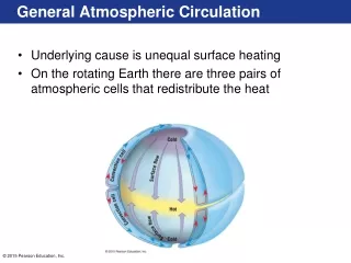
What is ACRE? • Atmospheric Circulation Reconstructions over the Earth • This initiative spans from • The recovery of historical global weather observations underpinning historical climate reanalyses • to • The development of tailored and downscaled products from the reanalysis 3D weather variables for • - climate applications, e.g., agricultural and biophysical models • - climate impacts, e.g., risk of high impact phenomena • - input into biophysical and production models.
Climate applications & biophysical models QCCCE Surface-observations-only historical reanalyses + downscaling Ecological Phenological Health & Disease Reinsurance Infrastructure Climate Monitoring Environmental Assessments Extremes, Impacts & Risks Water resources Agricultural Primary Industries Fisheries Energy Marine operations Cultural landscapes & built heritage Global surface daily to sub-daily weather observations • Three surface-observations-only historical reanalyses • 20th Century Reanalysis Project: • 1892 to present(supported in US by NOAA & DoE) • Early to mid-19th Century Reanalysis: • 1830s to present • North Atlantic-European Region Reanalysis: 1750/1800 to present
DATA RESCUE (MEDARE MedCLIVAR IEDRO SIGN) ATMOSPHERIC CIRCULATION RECONSTRUCTIONS OVER THE EARTH NATIONAL METEOROLOGICAL SERVICES (ECSN, ETCCDI, VACS, CMA, MeteoFrance) GLOBE TERRESTRIAL DATA MARINE DATA R E C L A I M NCDC CDMP GCOS AOPC/OOPC Surface Pressure Working Group International Surface Pressure Data Bank ICOADS HISTORICAL CLIMATE QUALITY REANALYSES
All Union Research Institute of Hydrometeorological Information WDC Atmospheric Reconstructions over the Earth Australian Bureau of Meteorology British Antarctic Survey Danish Meteorological Institute Deutscher Wetterdienst EMULATE Environment Canada ETH-Zurich GCOS AOPC/OOPC Working Group on Surface Pressure Hong Kong Observatory ICOADS Instituto Geofisico da Universidade do Porto Japanese Meteorological Agency Jersey Met Dept. KNMI MeteoFrance Meteorological and Hydrological Service, Croatia National Center for Atmospheric Research NOAA Climate Database Modernization Program NOAA Earth System Research Laboratory NOAA National Climatic Data Center NOAA National Centers for Environmental Prediction NOAA Northeast Regional Climate Center at Cornell U. NOAA Midwest Regional Climate Center at UIUC Norwegian Meteorological Institute Ohio State U. – Byrd Polar Research Center Proudman Oceanographic Laboratory SIGN - Signatures of environmental change in the observations of the Geophysical Institutes South African Weather Service UK Met Office Hadley Centre U. of Colorado-CIRES/Climate Diagnostics Center U. of East Anglia-Climatic Research Unit U. of Lisbon-Instituto Geofisico do Infante D. Luiz U. of Lisbon- Instituto de Meteorologia U. of Milan-IFGA U. Rovira i Virgili-CCRG International Surface Pressure Databank Sub-daily observations assembled under GCOS AOPC/OOPC Working Group on Surface Pressure GCOS/WCRP Working Group on Observational Data Sets for Reanalysis NOAA NCDC and NOAA ESRL: merging station data NOAA ESRL and NCAR (ICOADS): merging marine data Thank you to partners contributing observations:
Digitised Global Surface Observational Coverage (%) Data needs for ACRE-facilitated Historical Reanalyses of 3D weather conditions Improve Digital Holdings of Surface Observations
New activities in recovering, imaging and digitising historical ship logbook & remarks books observations • 2007/2008: British East India Company (EIC) logbooks (1780s-1830s) – held in the British Library (imaging by British Library, digitised by CDMP in US) 1,000 of the 2,000 logs have instrumental data [200K images] • 2008/2009: Extended World War 1 period logbooks (1914-1923) - held in the UK National Archives (imaging by UK National Archives) at least 8,000 logs [300K+ images] • 2007/2008: Printed/published logbooks of late 19th- early 20th Century Antarctic expeditions plus ships of exploration – online plus held in the Met Office Library & Archives (imaging & digitisation) • 2008:British hydrographic and survey vessel remarks books (1834-1909) – held at the UK Hydrographic Office (inventory of holdings in the archives of the UK Hydrographic Office) about 6,000 remarks books £400K split over two years - £200K in 2007/8 & £200K in 2008/9, from the climate research subcontract budget within the Defra/MoD funded Integrated Climate Programme
PROJECTED/POTENTIAL TIMELINE 2008-Spring 2009:The 20th Century Reanalysis Project: 1892 to present Version 1: 1908-1958 coming soon Version 2: 1892-2008 available Spring 2009 Mid-2009: British East India Company (EIC) logbooks (1780s-1830s) Imaged & Digitised 2009-2010: Final version of HadISST2 2010-2011: Extended World War 1 period logbooks (1914-1923) Imaged & Digitised 2009-2011: Early to mid-19th Century Reanalysis (with DoE and NOAA support) Version 3: mid-19th – 21st century would need all data by August 2010 improved version of NCEP model at higher resolution => hurricanes, high impact phenomena? potentially available in 2012 201?: British hydrographic and survey vessel remarks books (1834-1909) Imaging & Digitisation 201?: North Atlantic-European Region mid18th-early 19th Century Reanalysis: 1750/1800 to present
ACRE Project ManagerDr Rob Allan Climate Monitoring and Attribution Group, Met Office Hadley CentreE-mail: rob.allan@metoffice.gov.ukAlternative E-mail: allarob@googlemail.comACRE WWW Site: http://brohan.org/hadobs/acre/acre.htmlPhone: 01392 886904Fax: +44 (0)1392 885681International phone: +44 1392 886552Address: Met OfficeFitzRoy RoadExeter EX1 3PBU.K.