Download
1 / 60
650 likes | 907 Views
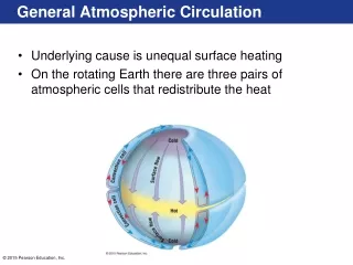
Atmospheric circulation. Moving air and heat around. Upper level flow. Lower level flow in “cells”; upper level flow to poles Warm air in tropics and cooler air at poles Depth of troposphere changes with latitude Steepest pressure gradient at mid-latitudes

E N D
Atmospheric circulation Moving air and heat around
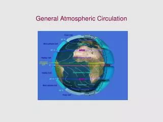
Upper level flow • Lower level flow in “cells”; upper level flow to poles • Warm air in tropics and cooler air at poles • Depth of troposphere changes with latitude • Steepest pressure gradient at mid-latitudes • At given altitude, pressure higher at equator • High altitude flow is from equator to poles down pressure gradient • Wind speeds greatest at mid-latitudes (jet streams)
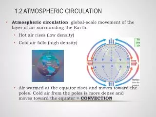
Circulation in Hadley cells • Buoyancy • Vertical air movements related to moisture and heat (DENSITY) • Pressure differences • Hadley cells • Horizontal air movements • Air move from high pressure to low pressure • Coriolis effect • Apparent deflection to right or left • Vertical component – centrifugal • Pushes an object away from center of rotation
ITCZ – convergence and uplift of hot, moisture laden air • Subsidence at 30 degrees – cool, dry air • Divergence due to high pressure at Earth’s surface
Coriolis effect and atmospheric circulation • Coriolis effect influences wind direction • Air only makes it about 1/3 of the way to the poles before it becomes dense enough to sink • End up with 3 sets of cells – by 30 deg, flow has been deflected 90 deg • Descending air turns back toward equator when it reaches the surface because it is again deflected to the right • Heats up when it gets back to equator and rises again.
On a CCW (eastward) rotating earth • Change in rotation rate with latitude (angular momentum • Winds due east or due west affected by centrifugal force – horizontal component is to the right in N hemisphere • Coriolis effect increases as speed increases • Coriolis effect increases with latitude - counterintuitive • No Coriolis at the equator
Very low temperature at poles • Increased air density near the surface • Movement of cold air outward (divergence) • Equatorward-moving cold air • Steep temperature gradient at polar front • Little mixing – wavelike structure around the hemisphere • Exact latitude varies
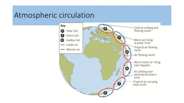
Fig. 4-7 Hadley Cell Hadley Cell Fig. 4-6
More realistic near poles Fig. 4-11
Features of the model • At boundaries, air is moving vertically • Surface winds are weak and erratic • Equatorial region • Lots of rain as humid air rises and loses moisture (rain forests) • Doldrums • Intertropical convergence zone (ITCZ) – winds converge • 30oN and S region • Sinking air is arid and evaporation >> precipitation (deserts and high salinity) • Horse latitudes
Features of the model • Air moves horizontally within the cells from areas of high pressure to areas of low pressure • Tropical areas – Hadley cells • Surface winds are strong and dependable • Trade winds or easterlies centered at ~15oN (northeast trade winds) and ~ 15oS (southeast trade winds) • Surface wind moves from horse latitudes to doldrums so come out of northeast in N hemisphere • Mid-latitude areas – Ferrel cells • Westerlies centered at ~ 45oN and ~45oS • Surface wind moves from horse latitudes to polar cells so comes out of southwest in the N hemisphere
Major surface wind and pressure systems of the world and their weather • These wind patterns move 2/3 of heat from tropics to poles.
Circulation of the Atmosphere • Over long term – 6-cell model is pretty good for describing average flow • Most of the variation from the 6-cell model is due to • Geographical distribution of landmasses • Different response of land and ocean to solar heating • Chaotic flow
The 6-celled model • Not exactly correct either • North - South variation • East-West variation • Seasonality • Land versus water distribution • Equator to pole flow of air different depending on amount of land at a particular longitude • ITCZ narrower and more consistent over land than ocean • Seasonal differences greater in N hemisphere (remember, more land)
Distributions of land masses • Differential heating and cooling • Land heats up and cools more rapidly
Winds over the Pacific on two days in Sept 1996 Stronger winds in red- orange Notes: Deviates from 6-cell model Strong westerlies hitting Canada Strong tradewinds (easterlies) over Hawaii Extratropical cyclone east of New Zealand
West-East variations • Air over chilled continents becomes cold and dense in the winter • Air sinks creating high pressure over continents • Air over relatively warmer waters rises (possibly with water vapor) creating low pressure zones over water • Air flows from high pressure to low pressure modifying air flow within cells • Reverse situation in summer • Effects pronounced in N hemisphere (mid-latitudes) where there is about the same amount of land & water
Monsoons • Pattern of wind circulation that changes with the season • Generally wet summers and dry winters • Linked to different heat capacities of land and water and to N-S movement of the ITCZ
Seasonality important Shifts in polar front and the ITCZ – meteorological equator
Wet season • In the spring, land heats (faster than water) • Warm air over land rises creating low pressure • Cool air flows from ocean to land • This humid air heats and rises (rains form)
Dry Season • Land cools (faster than ocean) • Air cools and sinks over land creating high pressure • Dry surface wind moves seaward • Warms and rises over water (with or without evaporation and rain over water)
Monsoons • Most intense over Asia where you have a huge land mass in the N and a huge ocean to the S • Monsoon over India causes wet season (summer) from April – October (up to 10 meters – 425 inches of rain per year) • Smaller monsoon in N America (Gulf of Mexico and SE)
ITCZ Dry season Wet season ITCZ
Sea and Land breezes • Daily changes in wind direction due to unequal heating and cooling of land versus water • Warm air during day on land rises and cool air from sea moves onshore (with or without water vapor) • Warmer air over water rises and cool air on land during the night sinks and moves offshore
Daytime Onshore Breeze Nighttime Offshore Breeze
Weather and our model • Cells are not really continuous features • Clusters of convective cells • Vary seasonally and locally and from day to day • Exact location of subtropical highs and polar front can create cyclonic flow
Weather • A result of smaller atmospheric motions and eddies • Usually caused by differences in atmospheric pressure, temperature and humidity (remember all of these affect density) • Weather forecasts try to predict smaller scale air movements
Cyclonic flow • Localized circular flow to the right (CCW – N hemisphere). Air moving into a low pressure center • Anticyclonic (CW – N hemisphere) flow – air flowing out of a high pressure center • Low pressure systems forming outside the tropics are extratropical cyclones • Extensive uplift of warm air • Features move along polar front
Air masses • Comparable to a water mass • Large body of air with uniform temperature and humidity (so density) throughout • Air over land or water will take on characteristics of surface below • Cold, dry land yields cold, dry air (high pressure) • Warm ocean surface yields warm, wet air (low pressure)
Air masses • Air masses form over land and water acquiring characteristics of their sources • Dry, cold air forms over Canada and Siberia… • Wet, moist air forms over equatorial waters… • When air masses move, they change characteristics • Temperature changes • Humidity or water content changes (lose water)
Air masses • Air masses can move within or between cells • Density differences prevent air masses from mixing (like water) – dense air slides beneath • Turbulence at boundaries between air masses • Fronts are boundaries between air masses of different densities • Fronts marked by changes in temperature and humidity
Fronts • A cold front is the leading edge of a cold-air mass advancing on a warm air mass • Displaces warm air • Cold air pushes under warm air (more toe shaped) • Get precipitation (rain or snow) just behind the front • A warm front is the advancing edge of a warm air mass • Displaces cold air • Rises over cold air in a wedge shape • Drops water in front of its leading edge
Polar front • About 50o N and S • Persistent boundary between converging warm and cold air masses • Get highly variable weather at these latitudes • Made up of a succession of waves that appear on weather maps as warm or cold fronts • Succession of warm, moist, subtropical air and cold dry polar air • Weather typical of N America and Europe • Narrow bands of strong winds called jet streams at altitudes of about 10 km
Ocean influence on weather • At mid-latitudes, warm and cold water masses steer weather patterns on land • Size and energy of water masses permits this • Large cold water masses in the N Pacific shift prevailing westerlies blowing across E North America • Cold, dry air from Canada displaces warm, moist air from the Gulf of Mexico and the tropical N Atlantic • So get cooler winters in the SE USA • Shifts in positions of water masses can cause changes in patterns • Warm equatorial surface waters in the Atlantic cause prolonged drought in Africa?
Storms • Regional atmospheric disturbances characterized by strong winds and, often, precipitation • Cyclones are intense storms around low pressure centers • Tropical disturbances (in Hadley cells/tropics) – cyclones (hurricanes) • Extratropical disturbances (in Ferrel cells/mid-latitudes) – also cyclones, usually in winter
Cyclones • Low pressure air • Rotates as winds converge and ascend (may bring water with them so get precipitation) • Form between or within air masses
Extratropical cyclones • Form at the boundary of polar and Ferrel cells (polar front) – mid-latitudes • Occur mainly in winter when temperature and density differences across the front are most pronounced • Cold air poleward of front is moving from the pole and east (more dense) • Warm air equatorward of the front is moving from the equator and west (less dense) • Cold air tries to slide below the warm air at the low pressure interface of a stationary front
Extratropical cyclone • May get alternating high and low pressure systems that bend the front • May get a twist in front due to opposite wind directions • Twisting air mass becomes cyclonic and circulates CCW in the N hemisphere (opposite Coriolis) • CCW flow is Coriolis driven because of the dominant flow of air masses at the edges • Part of the front is cut off • Wind speed increases as storm condenses • Air rushing toward center rises making a low pressure zone (air rises and loses moisture)
Cold air tries to dive below or push under warm air Higher pressure N of cold front so bending is towards lower pressure Cold air pushes warm air/front Low pressure intrusion into cold front Warm air rises (with or without water) at both fronts & yields precipitation at the fronts Cold front pushes warm front Eventually part of front is cut off and moves east
Extratropical cyclones • Cyclone gets embedded in the westerly winds so moves eastward • Typically 1000-2500 km in diameter • Last 2-5 days
Extratropical cyclones • Precipitation begins as circular flow develops • Precipitation caused by the lifting and cooling of the mid-latitude air (warmer air from the Ferrel cell) involved in the twist • Cold air advances behind it and does the lifting creating a cold front • Warm front occurs as the warm air is lifted on top of the retreating cold edge • Often these are called frontal storms and are the principle cause of weather in mid-latitudes
Nor’easters • Most powerful wind approaches from the east (polar cells) • Occur along the east coast of the US in winter