Download
1 / 17
170 likes | 303 Views
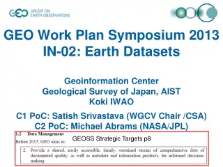
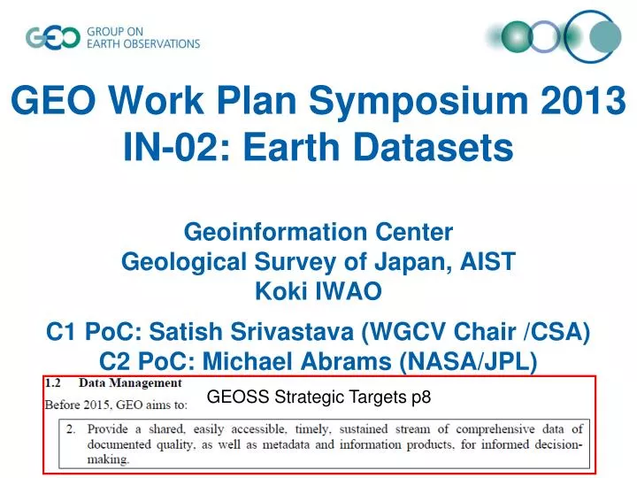
GEO Work Plan Symposium 2013 IN-02: Earth Datasets Geoinformation Center Geological Survey of Japan, AIST Koki IWAO C1 PoC: Satish Srivastava (WGCV Chair /CSA) C2 PoC: Michael Abrams (NASA/JPL). GEOSS Strategic Targets p8. C1 Advances in Life-cycle Data Management. Satoko Miura (CEOS/JAXA)

E N D
GEO Work Plan Symposium 2013IN-02: Earth Datasets Geoinformation CenterGeological Survey of Japan, AISTKoki IWAOC1 PoC: Satish Srivastava (WGCV Chair /CSA)C2 PoC: Michael Abrams (NASA/JPL) GEOSS Strategic Targets p8
C1 Advances in Life-cycle Data Management Satoko Miura (CEOS/JAXA) Satish Srivastava (WGCV Chair /CSA)38 members (as of Jan 2014) Thank you for your contributions!
(as of Jan 2014) C2 Development of Regional /Global Information and Cross-cutting Datasets Michael Abrams (NASA/JPL) 32 members Thank you for your contributions!
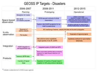
Scope of Task IN-02-C1 (Advances in Life-cycle Data Management) Expected Achievements by 2015 • In order to foster advances in life-cycle data management, GEO Best Practices, GEO Strategies and guidance documents will be developed. • Also a process and tools for incorporation of quality assurance information will be developed and its implementation will be verified by working with data integration system. Key Outputs • GEO Best Practices for data managementapproaches that encompass a broad perspective of the observation data life-cycle • GEO Strategy for the long-term preservation of Earth observation data • GEO Strategy for data quality assurance (QA4EO) • Data and Information Interoperability in CEOS and GEO • A general Earth System Spatial Grid (ESSG)for GEOSS data long term registration, cloud management, sharing access, integrated analysis and SBAs application.
3: Develop a CEOS Quality Assurance Framework for Earth Observation (QA4EO) and implement processes and structure for CEOS data and information Decided to refocus QA4EO activities for making concrete progress to demonstrate it to stakeholders (At WGCV-36 Plenary in May 2013) Steps of the new approach are: 1. Short-term examples addressing "stakeholders" 2. Reassess (lessons learnt) and extend to show case 3. Reassess the first example cases (lessons learnt) 4. Extend the show case repository to address the science and data product provider community by selecting case by case from the shop list, ideally covering all "compartments": level 1, atmosphere, terrestrial, ocean Work is in progress: • A showcase on Ozone showing the importance of QA4EO was prepared and presented at the CEOS SIT Technical Workshop in September 2013. • New case studies recently published to QA4EO website (http://www.qa4eo.org). • Case studies repository to be expanded to address a larger segment of the science and data product provider community (i.e. level 1, atmosphere, terrestrial, and ocean). Recent Progress :
Recent Progress : 4. Enabling Data and Information Interoperability and Harmonization in CEOS and GEO Item 1: Complete full list of test sites needed across all space domains to underpin interoperability (May 2013) STATUS: A first level list of test sites has been identified and refinements to this list are on-going. Item 2: Identify priority requirements, parameters and uncertainties needed by CEOS WGC and VCs and SBAs (Sep 2013) STATUS: A request to the VCs and WGClimate has been made for their input as to the key parameters/requirements for Cal/Val. Item 3: Prototype pre-operational satellite to satellite (optical domain) bias correction service/database (based on an amalgam of agency developed systems) (Oct 2013) STATUS: The Landnet prototype project has been initiated with a first meeting scheduled in Jan 2014 and work continues on the use of Libya 4. Work is also ongoing to compare and update databases such as DIMITRI and SADE.
Recent Progress : 4. Enabling Data and Information Interoperability and Harmonization in CEOS and GEO Cont. Item 4: Establish operational collection of cal data over CEOS test sites by agencies and their accessibility through automated services such as CWIC tools (July 2013) STATUS: Agencies are encouraged to provide cal data from satellites on test sites to community data bases and/or make such data readily searchable. WGCV looks to WGISS for ongoing support in this activity. Item 5: Establish and publish methodologies to aid interoperability, Cal/Val particularly to aid developing space nations and harmonization of others (ongoing). STATUS: This is an ongoing task with outputs being submitted onto the cal/val portal.
Scope of Task IN-02-C2(Development of Regional /Global Information and Cross-cutting Datasets including socio-economic data) Expected Achievements by 2015 • Produce a global, coordinated and integrated Digital Elevation Model (DEM) • Improve Global Map and foster its use across Societal Benefit Area • Develop a global digital geological map of the world. • Support the development of a global soil information system • Develop a global road and human settlements map Key outputs • ASTER GDEM • Global Map (ISCGM 1km500m resolution) • OneGeology • ISRIC Global Soil Information (Harmonized world SOIL DATABASE) • gROADS & AGURAM (ICSU/CIESIN/AIST), etc
The OneGeology project continued to build momentum around the development of a dynamic digital geological map of the world (http://www.onegeology.org; see figure). An increasing number of full and open datasets were accessed in a usable and editable format. Recent Progress and Key Outputs for 2013 IN-02-C2 Collaboration with the European Marine Observation and Data Network (EMODNET) enhanced access to European seas’ data. Work continued to (i) transfer know-how to the developing world, (ii) develop a 3D geoinformation infrastructure with OneGeology Europe, and (iii) support the development of a global soil information system incorporating data from global, regional and national soil data projects (led by ISRIC; see GlobalSoilMap.net ).
Japan (GSI) and other members of the ISCGM designed plans for a Global Map of larger-scale (1:250,000), to be implemented between 2013 and 2017. Global Map datasets provide a full and consistent coverage of land on Earth – at 1km resolution or higher. Efforts were launched to foster the use of Global Map across Societal Benefit Areas. Recent Progress and Key Outputs for 2013 IN-02-C2 The Global Roads Open Access Dataset (gROADS) was prepared for release. Japan (AIST) and ICSU (CODATA) sustained their efforts to collect, maintain and evaluate remote sensing and GIS data for global human settlement and road mapping. International collaboration continued on high-resolution land-cover products (see Task SB-02).
US and Japan progressed towards a global, coordinated and integrated Digital Elevation Model (DEM), facilitating interoperability among existing Digital Elevation Model data sets. • Develop wide area dataset of ALOS PRISM DSM (Digital Surface Model) and its validation (by JAXA). JAXA is developing validated wide area dataset of ALOS PRISM DSM (Digital Surface Model). • CSIRO, Australia, with support from the ASTER project, produced and released the first ever continental mineral maps. • The series of maps for Australia were registered in the GEOSS Common Infrastructure. . Recent Progress and Key Outputs for 2013 IN-02-C2
Discussions are ongoing to identify an organization to create the mineral maps on a global scale. • US is approaching registration of a near-global high spatial resolution land-water boundary map, based on the newly released version of the SRTM topographic data set. • In 2014, this data set will be entered into the GEOSS Common Infrastructure. Recent Progress and Key Outputs for 2013 IN-02-C2
Institutions and Development QA4EO? INfrastructure ID-01 Data Sharing ID-03 GEO Lavel? ID-04 core set of essential valuables Broker IN-01 Observations IN-03 GCI IN-05 GEOSS Synergies with other Tasks Opportunities for collaboration Interface WFS, 3D… Standards Societal Benefits 7/9SBA+SBs Source data GCI Register AG-01 Soil Moisture EN-01 Energy and Geo-Resources EC-01 C2 IN-02 DEM CL-02 Carbon EC-01 C1 Global Map WA-01 HE-02 Mercury One GEOLOGY Soil CfP Geohazard SB-02 LANDCOV Global Road SB-03 Forest Urban SB-05 Human Impacts SB-04 URBAN
Challenges and Issues (evolution since 2013 Work Plan Symposium) Comments from Infrastructure Implementation Board… • Most of the data/projects existed without GEO • How to encourage new dataset development under the framework of GEO? • Essential socio-economic information… • Missing socio-economic information (Free and Open)
Challenges and Issues (evolution since 2013 Work Plan Symposium) Data or Services mentioned in the 12-15 GWP are already registered/searchable to GCI or not? Each coordinators are requested to check the excel sheet
Gaps in Implementation (pls be specific) Ideas for Accelerating Implementation • Whether Essential SB valuables are already accessible via GCI? • Encouraging Overarching Earth dataset management will be required
Ideas for Accelerating Implementation from Infrastructure Implementation Board • Common Data Management Principleswill be discussed for future Plenary (similar to that of Data Sharing Principles) Such as… • Encourage • Data development.. • Life Cycle Data Management/Preservations.. • Data Quality.. • …