Download
1 / 1
10 likes | 135 Views
Seamless Access to NASA Data from Operational Decision Support Systems. GSFC Earth Sciences (GES) Data and Information Services Center (DISC) Distributed Active Archive Center (DAAC) teng@disc.gsfc.nasa.gov. William Teng 1,2 , Hualan Rui 1,2 , Naphtali Rishe 3 , Robert Tetrault 4

E N D
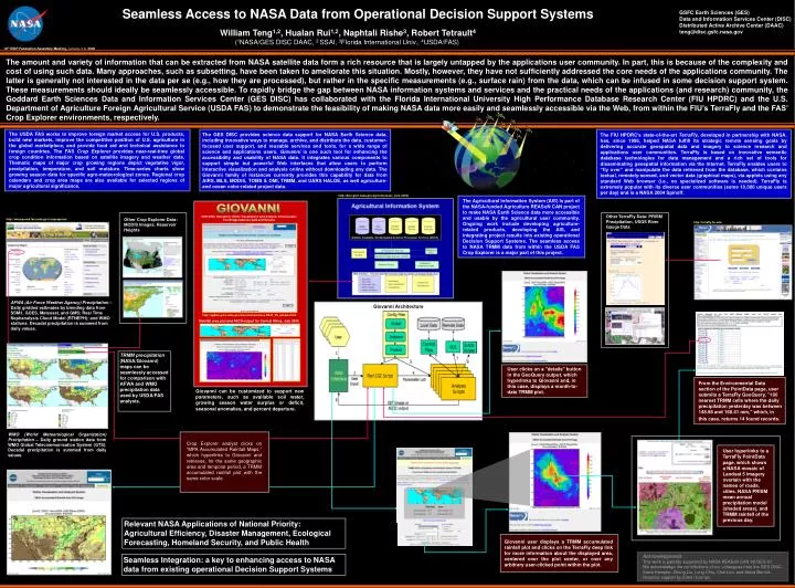
Seamless Access to NASA Data from Operational Decision Support Systems GSFC Earth Sciences (GES) Data and Information Services Center (DISC) Distributed Active Archive Center (DAAC) teng@disc.gsfc.nasa.gov William Teng1,2, Hualan Rui1,2, Naphtali Rishe3, Robert Tetrault4 (1NASA/GES DISC DAAC, 2 SSAI, 3Florida International Univ., 4USDA/FAS) 16th ESIP Federation Assembly Meeting, January 4-6, 2006 The amount and variety of information that can be extracted from NASA satellite data form a rich resource that is largely untapped by the applications user community. In part, this is because of the complexity and cost of using such data. Many approaches, such as subsetting, have been taken to ameliorate this situation. Mostly, however, they have not sufficiently addressed the core needs of the applications community. The latter is generally not interested in the data per se (e.g., how they are processed), but rather in the specific measurements (e.g., surface rain) from the data, which can be infused in some decision support system. These measurements should ideally be seamlessly accessible. To rapidly bridge the gap between NASA information systems and services and the practical needs of the applications (and research) community, the Goddard Earth Sciences Data and Information Services Center (GES DISC) has collaborated with the Florida International University High Performance Database Research Center (FIU HPDRC) and the U.S. Department of Agriculture Foreign Agricultural Service (USDA FAS) to demonstrate the feasibility of making NASA data more easily and seamlessly accessible via the Web, from within the FIU’s TerraFly and the FAS’ Crop Explorer environments, respectively. The USDA FAS works to improve foreign market access for U.S. products, build new markets, improve the competitive position of U.S. agriculture in the global marketplace, and provide food aid and technical assistance to foreign countries. The FAS Crop Explorer provides near-real-time global crop condition information based on satellite imagery and weather data. Thematic maps of major crop growing regions depict vegetative vigor, precipitation, temperature, and soil moisture. Time-series charts show growing season data for specific agro-meteorological zones. Regional crop calendars and crop area maps are also available for selected regions of major agricultural significance. The GES DISC provides science data support for NASA Earth Science data, including innovative ways to manage, archive, and distribute the data, customer-focused user support, and reusable services and tools, for a wide range of science and applications users. Giovanni is one such tool for enhancing the accessibility and usability of NASA data. It integrates various components to support simple but powerful Web interfaces that allow users to perform interactive visualization and analysis online without downloading any data. The Giovanni family of instances currently provides this capability for data from AIRS, MLS, MODIS, TOMS & OMI, TRMM, and UARS HALOE, as well agriculture- and ocean color-related project data. The FIU HPDRC’s state-of-the-art TerraFly, developed in partnership with NASA, has, since 1996, helped NASA fulfill its strategic remote sensing goals by delivering accurate geospatial data and imagery to science research and applications user communities. TerraFly is based on innovative semantic database technologies for data management and a rich set of tools for disseminating geospatial information via the Internet. TerraFly enables users to “fly over” and manipulate the data retrieved from the database, which contains textual, remotely-sensed, and vector data (graphical maps), via applets using any standard Web browser (i.e., no specialized software is needed). TerraFly is extremely popular with its diverse user communities (some 10,000 unique users per day) and is a NASA 2004 Spinoff. http://disc.gsfc.nasa.gov/agriculture/ais_sum.shtml The Agricultural Information System (AIS) is part of the NASA-funded Agriculture REASoN CAN project to make NASA Earth Science data more accessible and usable by the agricultural user community. Ongoing work include developing agriculture-related products, developing the AIS, and integrating project results into existing operational Decision Support Systems. The seamless access to NASA TRMM data from within the USDA FAS Crop Explorer is a major part of this project. GIOVANNI Other TerraFly Data: PRISM Precipitation, USGS River Gauge Data GES-DISC Interactive Online Visualization and Analysis Infrastructure The Bridge between Data and Science Other Crop Explorer Data: MODIS Images, Reservoir Heights http://www.pecad.fas.usda.gov/cropexplorer/ http://terrafly.fiu.edu/ AFWA (Air Force Weather Agency) Precipitation – Daily gridded estimates by blending data from SSM/I, GOES, Meteosat, and GMS; Real Time Nephanalysis Cloud Model (RTNEPH); and WMO stations. Decadal precipitation is summed from daily values. Giovanni Architecture http://agdisc.gsfc.nasa.gov/Giovanni/archives.3B42_V6_dekad.shtml Rainfall area plot and ASCII output for Central Africa, July 2005 TRMM precipitation (NASA/Giovanni) maps can be seamlessly accessed for comparison with AFWA and WMO precipitation data used by USDA/FAS analysts. User clicks on a "details" button in the GeoQuery output, which hyperlinks to Giovanni and, in this case, displays a month-to-date TRMM plot. From the Environmental Data section of the PointData page, user submits a TerraFly GeoQuery, "100 nearest TRMM cells where the daily precipitation yesterday was between 148.98 and 160.41 mm," which, in this case, returns 14 found records. Giovanni can be customized to support new parameters, such as available soil water, growing season water surplus or deficit, seasonal anomalies, and percent departure. WMO (World Meteorological Organization) Precipitation – Daily ground station data from WMO Global Telecommunication System (GTS). Decadal precipitation is summed from daily values. Crop Explorer analyst clicks on “MPA Accumulated Rainfall Maps,” which hyperlinks to Giovanni and retrieves, for the same geographic area and temporal period, a TRMM accumulated rainfall plot with the same color scale. User hyperlinks to a TerraFly PointData page, which shows a NASA mosaic of Landsat 5 imagery overlain with the names of roads, cities, NASA PRISM mean annual precipitation model (shaded areas), and TRMM rainfall of the previous day. Relevant NASA Applications of National Priority: Agricultural Efficiency, Disaster Management, Ecological Forecasting, Homeland Security, and Public Health Giovanni user displays a TRMM accumulated rainfall plot and clicks on the TerraFly deep link for more information about the displayed area, centered over the plot center, or over any arbitrary user-clicked point within the plot. Location of the sub-region in Argentina for the rain rate analyses. Acknowledgments This work is partially supported by NASA REASoN CAN 02-OES-01. We acknowledge the contributions of our colleagues from the GES DISC: Steve Kempler, Zhong Liu, Long Chiu, Chai Lim, and Steve Berrick. Graphics support by Edee Ocampo. Seamless Integration: a key to enhancing access to NASA data from existing operational Decision Support Systems