Download
1 / 11
110 likes | 260 Views
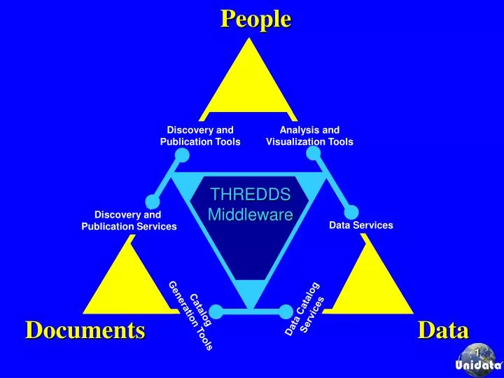
People. Discovery and Publication Tools. Analysis and Visualization Tools. THREDDS Middleware. Discovery and Publication Services. Data Services. Data Catalog Services. Catalog Generation Tools. Documents. Data.

E N D
People Discovery andPublication Tools Analysis and Visualization Tools THREDDS Middleware Discovery and Publication Services Data Services Data CatalogServices CatalogGeneration Tools Documents Data
Thematic Data Servers (combining IDD “push” with several forms of “pull” and DL discovery) User applications: e.g., LAS, McIDAS, MetApps/VisAD, IDL, MatLab... DLESE Digital Library for Earth-System Education Discovery DODS, ADDE, &FTP protocols DLinterchangeprotocol Satellite Images, e.g. Satellite Images, e.g. Satellite Images, e.g. Hydrology Data, e.g. Geophysical Data, e.g. Satellite Imagery... IDD IDD IDD IDD IDD
Compound Documents Analysis and Display Software i.e.,electronic publications with embedded pointers to datasets and tools Discovery CenterCatalog Systemse.g. DLESE, NSDL, GCMD e.g. IDV, VGEE,LAS, INGRID, IDL, GDS Discovery and Usage Metadata Middleware e.g. THREDDS catalog generators, servers, harvesters Data Server Softwaree.g. FTP, OPeNDAP, ESG, OpenGIS, Web services Data Storage Systeme.g., Disk, RAID, Mass storage)
Browser-base Thin Client Access • LDEO/IRI web site publishes catalog of datasets available on server at UCAR • Catalog resides and is updated at UCAR • Browsing of datasets on UCAR server from LDEO server • Also enables analysis and display of datasets on UCAR server using tools on LDEO server
THREDDS, GIS, DL Interoperability THREDDS Servers GIS Servers THREDDS Server GIS Server THREDDS Server Satellite, radar, forecast model output, … datasets GIS Server Demographic, infrastructure, societal impacts, … datasets THREDDS Client Applications GIS Client Applications OGC or OPeNDAPADDE. FTP… protocols OpenGIS Protocols: WMS, WFS, WCS OGC or proprietary GISprotocols Metadatacrosswalk Metadatacrosswalk Open Archives Initiative (OAI) Metadata Harvesting Digital Library Discovery Systems
Enhanced Catalogs Model output Weather Obs Digital Library Catalog System ESML or NCML Generator IDD Data Catalog Harvesting Enhanced Catalogs Inventory Catalog Generator Enhanced Inventory Catalog and Data Server THREDDS Inventory Catalog and Data Server THREDDSData Server IDD Data Mining Engine IDD Case Study Catalog Third Party THREDDS Catalog Server Event Gazetteer Third Party THREDDS Catalog Server Third Party THREDDS Catalog Server
THREDDS 2G Additions • Data providers • CIESIN (Consortium for International Earth Science Information Network, Bob Downs) • CUAHSI (Consortium of Universities for Advancement of Hydrologic Science, David Maidment) • ESIG/NCAR (NCAR Environmental Societal Impacts Group, Bob Harriss) • Earthscope (UCAR UNAVCO, Chuck Meertens) • GEON (GEOphysical Network, Chaitan Baru, UCSD San Diego Supercomputer Center) • ESRI GIS Community • Analysis and Display Tools • ESRI GIS Clients (ESRI, Inc., Jack Dangermond, President) • OGCClients (Open GIS Consortium, David Schell, President) • MyWorld (Northwestern educational GIS Client, Danny Edelson)
THREDDS 2G GIS and Web Services Interoperability • ADL(Gazetteer Services The University of California, Santa Barbara, Linda Hill and Michael Goodchild) • DLESE Evaluation Services (The University of Colorado CIRES, Susan Buhr) • DLESE Data Services (Tamara Ledley) • DLESE Program Center Digital Library for Earth System Education (Mary Marlino) • ESRI(Jack Dangermond, President) • OPeNDAP (The University of Rhode Island Open source Project for a Network Data Access Protocol -- formerly DODS, Peter Cornillon) • LAITS (Laboratory for Advanced Information Technology and Standards,Liping Di, George Mason University) • NSDL Evaluation Services (University of Colorado, Tamara Sumner) • OGC (Open GIS Consortium, David Schell, President) • SWEET(Semantic Web for Earth and Environmental Terminology, Rob Raskin)
More Information • http://www.unidata.ucar.edu/projects/THREDDS/ • ben@unidata.ucar.edu