Download
1 / 29
290 likes | 449 Views
1 st EEA/EIONET workshop – Maritime 26 Oct 2010 at European Environment Agency, Copenhagen. Maritime spatial planning – approaches for effectiveness evaluation Søren Anker Pedersen, ETC/Water. What is Maritime Spatial Planning (MSP)? MSP and fisheries in German offshore waters

E N D
1st EEA/EIONET workshop – Maritime 26 Oct 2010 at European Environment Agency, Copenhagen Maritime spatial planning – approaches for effectiveness evaluation Søren Anker Pedersen, ETC/Water
What is Maritime Spatial Planning (MSP)? MSP and fisheries in German offshore waters (The EMPAS project – MSP in practice)
1) What is Maritime Spatial Planning(MSP)? MSP a tool to: - optimize the human used of the marine ecosystem - optimize benefits from ecosystem goods and services The purpose… Achieve “Good Environmental Status” within the marine ecosystems, while promoting long-term sustainable use of marine resources - within the framework and “guidance” of EU Maritime Policy
MSP does not lead to a one-time plan. It is a continuing, iterative process that learns and adapts over time. Figure from: Guide on MARINE SPATIAL PLANNING – A Step-by-Step Approach toward Ecosystem-based Management by Charles Ehler and Fanny Douvere, UNESCO, 2009.
The PlanCoast Project 2006-2008 Step 1: Assessing the context and establishing a general framework for IMSP Step 2: Drawing up a guiding vision Step 3: Refining the stocktake and mapping Step 4: Analysis: identifying issues and problems Step 5: Developing solutions for the problems identified Step 6: Drawing up a plan Step 7: Implementation Step 8: Evaluation
2. MSP and fisheries in German offshore waters (The EMPAS project – MSP in practice)
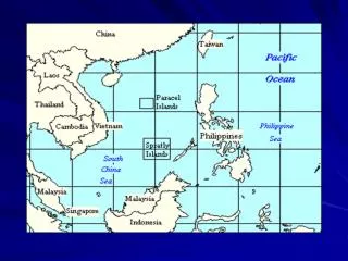
1 Baltic Sea 4 4 2 1 3 6 2 5 North Sea 3 Environmentally Sound Fisheries Management in Marine Protected Areas(EMPAS) project 2006-2008 • German Federal Agency for Nature Conservation (BfN) • responsible for: • selection, • designation, • management ICES advice on fisheries management in N2K sites www.ices.dk/projects/empas.asp
NATURA 2000-protected habitats and species in the North Sea Habitat-Directive (FFH-Directive) and the Bird Directive (BD) FFH-Habitats Sandbank, Reefs Benthic commuities FFH-Annex II Marine Mammals Harbour porpoise, Harbour Seal, Grey Seal Shad, Twaite Shad, Hounting, River Lamprey, Sea Lamprey, Sturgeon FFH-Annex II Fish Species Red-throated Diver, Black-throated Diver, Terns, Common Scoter, Long-tailed duck, etc. BD Annex I and migratory bird species
Natura 2000 sites Dogger Bank Sylt Outer Reef Borkum Reef Ground Protected habitat types: "sandbanks" and "reefs"
The EMPAS Project: Targets For each designated Natura 2000 site in the German EEZ: • 1. Mapping of fishing activities and effort; • 2. Analysis of impact of fishing activities on habitats and species; • 3. Identify conflicts between fishing activities and nature conservation objectives/targets; • Develop management options
Natura 2000 sites and International Fisheries Example: 2004
Example: Sylt Outer Reef Fock et al., 2007
Example: Fock et al., 2007
Benthic habitats and typical species: • Destructive effects of bottom contacting gear Conflict analysis: Fishing activities and nature conservation targets Impact of bottom trawls on "sandbanks" and "reefs"
Fine scale distribution of fishing activities • Consultation and cooperation with fishers: • Fishing track plotters (GPS), sea charts, and personal experiences • Explain fisheries data and misunderstandings • Contribute VMS data • and fishery information • Find solutions to conflicts
The EMPAS project results and the future • From no-change option to partial and full closures for fisheries • The EMPAS results are starting points to develop a management strategy for Natura 2000 sites • Final management plans have not yet been developed/implemented • The revised CFP should harmonize different national approaches/proposals to Natura 2000 management
Maritime Spatial Planning German EEZ North Sea 2020: 12,000 MW 2030: 25,000 MW Berkenhagen et al. (2010)
MSP and fisheries in the German EEZ • - cumulative losses and benefits • Wind farm approvals case-by-case overlooks the cumulative impact of planned and projected wind farms on fisheries • Better understanding of the impact of wind farms establishments on individual vessels, fishing association and harbour towns in future Useful information in MSP and trade-off evaluation are: • cumulative losses (benefit losses) • costs of displacement of fishing effort to other areas • habitats affected by the wind farm influence species • possible benefits: • a) new species attracted by the different habitats, • b) marine aquaculture or • c) the closure leads to increasing catch possibilities outside • cumulative effects of closing many areas for fishing • (wind farms, military areas, shipping lines, Natura 2000 areas, etc.)
Summary • Uniform approach to data collection, harmonization and classification • Coherent ecological information • Coherent information on human activities • Identify scientific principles/methodologies for e.g. assessing multiple pressures, environmental status assessment etc. • Link economic values to ecosystem benefits • Considering economical and social impacts in line with ecological impacts will increase the willingness for seeking a sound and sustainable compromise
Monitoring the conservation status DocHab-04-03/03 rev.3