Download
1 / 1
10 likes | 83 Views
Update on the NOAA Polar Satellite Program, Data, and Products. J. Machol 1,2* , J. Green 1 , W Denig 1 , T. Sotirelis 3 , D. Wilkinson 1 , J. Rodriguez 1,2 and R. Redmon 1.

E N D
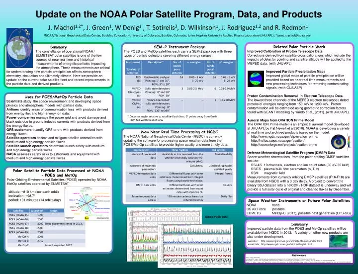
Update on the NOAA Polar Satellite Program, Data, and Products J. Machol1,2*, J. Green1, W Denig1 , T. Sotirelis3, D. Wilkinson1, J. Rodriguez1,2 and R. Redmon1 1NOAA/National Geophysical Data Center, Boulder, Colorado; 2University of Colorado, Boulder, Colorado; Johns Hopkins University Applied Physics Laboratory (JHU APL); *janet.machol@noaa.gov Related Polar Particle Work Improved Calibration of Proton Telescope Data Corrections derived from satellite cross calibrations which include the impacts of detector pointing and satellite altitude will be applied to the MEPED data. (with JHU APL) Improved Particle Precipitation Maps Improved global maps of particle precipitation will be provided based on near real time measurements and new processing techniques for removing contaminating signals. (with CU/LASP) Proton Contamination Removal in Electron Telescope Data The lowest three channels of the MEPED electron telescopes detect protons of energies ranging from 150 keV to 1200 keV. Proton contamination will be estimated using geometric correction factors found with GEANT modeling by Yando et al., [2011]. (with JHU APL). Auroral Maps from OVATION Prime Model The OVATION Prime model is an empirical auroral model developed at JHU APL by Pat Newell et al [2010]. NOAA is developing a variety of real time and archived products based on the model. http://www.ngdc.noaa.gov/stp/ovation_prime/ http://helios.swpc.noaa.gov/ovation/ http://sourceforge.net/projects/ovation-prime Defense Meteorological Satellite Program (DMSP) Data Space weather observations from the polar orbiting DMSP satellites include: SSJ4/5 19 channels, electron and ion count rates (30 eV-30 keV) SSIES plasma bulk flow parameters (n, T, v) SSM magnetic field Measurements from currently orbiting DMSP satellites (F16-F18) are available from NGDC with a 3 day delay. A project to convert the binary SSJ dataset into a netCDF / HDF dataset is underway and will provide a full solar cycle of original and cleaned fluxes by December. Summary The constellation of operational NOAA / EUMETSAT polar satellites is one of the few sources of near real time and historical measurements of energetic particles impacting the atmosphere. These measurements are critical for understanding how particle precipitation affects atmospheric chemistry, circulation and ultimately climate. Here we provide an update on the current polar satellite fleet and recent improvements to the particle data and derived products. SEM-2 Instrument Package The POES and MetOp satellites each carry a SEM-2 package with three types of particle detectors covering different energy ranges. * Detector angles relative to satellite-Earth line; 0° points away from Earth. FOV: full-width field of view Uses for POES/MetOp Particle Data Scientists study the space environment and developing space physics and atmospheric models with particle data. Airlines identify areas of communication loss with products derived from energy flux and high energy ion data. Power companies manage the power grid and avoid damage and black outs due to ground induced currents with products derived from the energy fluxes. GPS customers quantify GPS errors with products derived from energy fluxes. Satellite operators assess and mitigate satellite anomalies with medium and high energy particle fluxes. Satellite launch operators determine launch safety with medium and high energy particle fluxes. NASA assesses safety risks to astronauts and equipment with medium and high energy particle fluxes. New Near Real Time Processing at NGDC The NOAA National Geophysical Data Center (NGDC) is currently updating the software for processing space weather data from the POES/MetOp satellites to provide higher quality and more timely data. Polar Satellite Particle Data Processed at NOAA – POES and MetOp Polar Orbiting Environmental Satellites (POES) operated by NOAA. MetOp satellites operated by EUMETSAT. altitude: ~810 km (low earth orbit) inclination: ~98.7° period: 101 minutes (14 orbits/day) Space Weather Instruments on Future Polar Satellites NOAA none US Air Force possible EUMETS MetOp-C (2017), possible next generation (EPS-SG) sample POES data Summary Improved particle data from the POES and MetOp satellites will be available from NGDC in 2012. A variety of other new products are also under development. website: http://www.ngdc.noaa.gov/stp/satellite/poes/index.html email lists: http://www.ngdc.noaa.gov/stp/mailinglist.html References aurora image: Thilo Bubek orbiting satellite image: http://tornado.sfsu.edu/geosciences/classes/m415_715/Monteverdi/Satellite/PolarOrbiter/Polar_Orbits.html Newell, P. T., T. Sotirelis, and S. Wing (2010), Seasonal variations in diffuse, monoenergetic, and broadband aurora, J. Geophys. Res., 115, A03216, doi:10.1029/2009JA014805. Yando, K., R. Millan, J. Green, and D. Evans (2011), A Monte Carlo simulation of the NOAA POES Medium Energy Proton and Electron Detector instrument, J. Geophys. Res., 116, doi:10.1029/2011JA016671.