Download
1 / 31
310 likes | 393 Views
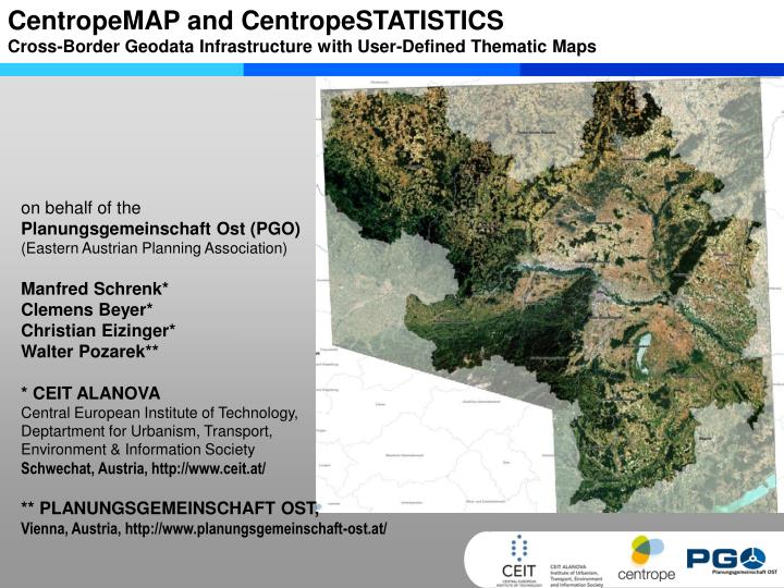
CentropeMAP and CentropeSTATISTICS Cross-Border Geodata Infrastructure with User-Defined Thematic Maps. on behalf of the Planungsgemeinschaft Ost (PGO) (Eastern Austrian Planning Association) Manfred Schrenk* Clemens Beyer* Christian Eizinger* Walter Pozarek**

E N D
CentropeMAP and CentropeSTATISTICSCross-Border Geodata Infrastructure with User-Defined Thematic Maps on behalf of thePlanungsgemeinschaft Ost (PGO)(Eastern Austrian Planning Association) Manfred Schrenk*Clemens Beyer* Christian Eizinger* Walter Pozarek** * CEIT ALANOVACentral European Institute of Technology, Deptartment for Urbanism, Transport, Environment & Information Society Schwechat, Austria, http://www.ceit.at/ ** PLANUNGSGEMEINSCHAFT OST, Vienna, Austria, http://www.planungsgemeinschaft-ost.at/
The Centrope Region • CentropeMAP • CentropeSTATISTICS • Technical Implementation • Future Perspectives
CENTROPE Region • Region • Austria • Czech Republic • Hungary • Slovak Republic
CENTROPE Partner Regions • Czech Republic • Region: South Moravia • City: Brno • Interested: Olomouc • Slovak Republic • Region: Bratislava, Trnava • Cities: Bratislava, Trnava • Hungary • Region (county): Györ-Moson-Sopron • Cities: Györ, Sopron • Austria • Region (federal states): Burgenland, Lower Austria, Vienna • Cities: Eisenstadt, St. Pölten, Vienna • Interested: Wiener Neustadt
CENTROPE Region Population • 6 million • of which 3 million in cities Economy • 3.8 million employed • 55 – 65 % employed in service sector • unemployment rate between 4 and 14 % • GDP growth between0.8 % and 3.6 %since 2003 Infrastructure • 3 international airports (Brno, Bratislava, Vienna) • 2 Danube river ports (Vienna, Bratislava) • Pan-European corridors (Source: Wikipedia)
Political declaration of Kittsee, 2003 + Political memorandum St. Pölten, 2005 Main goals • international attractivity • sustainable integration • location with high quality of life • professional co-operation
The Centrope Region • CentropeMAP • CentropeSTATISTICS • Technical Implementation • Future Perspectives
Challenges Centrope MAP Challenges • Legal planning responsibilities on different levels • Data responsibilities on different levels • Administrative boundaries = data boundaries • No common data infrastructure available,only isolated applications
Project Approach • CentropeMAP is a process, not a single project - an ongoing cross-border exchange of planning related information with benefits for all participating partners. • CentropeMAP does not generate new data itself but relies on integrating, structuring and harmonising existing information from the data maintaining sources. Data will be made available via OGC standard compliant web map services. • Quality of CentropeMAP is depending on quality and up-to-dateness of the provided information • CentropeMAP is an opensystem able to integrate digital information from different scale levels and different sources. CentropeMAP data itself can also be integrated in external applications via OGC WMS.
Geodata Input to Centrope Map Statistical data Land use (Corine Land Cover 2006, Level 3, all layers separately) 34 categories used Administrative borders NUTS 2, NUTS 3, LAU 2 Database NUTS 2, NUTS 3, LAU 2 (up to availability and meaning) Area: cadastral area, area of durable settlement, forest, water bodies, ... Population: Development, migration balance, balance of births prognoses, age groups, nationalities educational qualification household size, secondary residences employed, unemployed strucutre of income, purchasing power settlement structure Occupation and Economy: places of work, business structure branch structure, value added jobs, commuter structure agriculture, forestry, tourism Infrastructure: (Data linked with punctiform infrastructure data) administration, education, social, leisure, recreation, tourism, culture, ... Visualisation of the data based on administrative borders (maps, diagrams) Remarks: Phase 1: downloadable print-ready maps (PDF) Phase 2: online interactive maps Infrastructure (linear): road network railway network conductions, pipes Infrastructure (punctiform): transportation (stops, P+R) education health/social administration leisure/recreation culture supply and disposal other Planning: builiding land protection areas Natura 2000 world heritage ground water protection flood protection mining
CentropeMAP Web Application • datasets come directly from project partners no redundancy, always up-to-date • functions: Zoom, Pan, Query, Search, Tell-A-Friend, Measurement • hundreds of layers for the whole region and sub-regions • background maps from simplified views to high-resolution satellite images and aerial views (ortho-photos) • map generation on the fly
Data Examples elevation, road network, railway network, urban fabric, inland waters
Data Examples high resolution orthophoto, environmental protected territory (Znojmo, CZ)
Data Examples urban fabric, rivers, inundation risk areas, high ground water level (<2m) (Danube, Lower Austria)
Data Examples Corine Land Cover Level 3 (Lake Neusiedl Region)
Data Examples building land (residential/commercial), road network (Krems, Lower Austria)
The Centrope Region • CentropeMAP • CentropeSTATISTICS • Technical Implementation • Future Perspectives
Project Partners • CentropeSTATISTICS is a cross-border database project of these co-operating statistics offices/departments in the Centrope Region(on behalf of PGO - Planungsgemeinschaft Ost/Eastern Austrian Planning Association, • and technically led by CEIT ALANOVA gemeinnützige GmbH) • Czech Republic:CZSO - Czech Statistical Office – Český statistický úřad (ČSÚ) • Slovak Republic:Statistical Office of the SR – Štatistický úrad Slovenskej republiky • Hungary:HCSO - Hungarian Central Statistical Office – KSH - Központi Statisztikai Hivatal • Austria:Statistics Departments of the three Austrian federal states Burgenland, Lower Austria and Vienna • Workshops: • September 2008 in Schwechat, March 2009 in Schwechat,September 2009 in Brno,June 2010 in Schwechat
CentropeSTATISTICS Challenges • Develop spatio-temporal matrix for attribute data • Which data for which region, collection date, classification, ... • Define attribute data catalogue of “most wanted data classes“ • demography, migration first data group, online since 2010 • economy, household income • commuter, transport statistics • environmental indicators, ... • Main issue: Overcome the “language barrier“ (extending the CentropeMAP Online Dictionary, a database with statistical and planning related technical terms editable by anyone)
CentropeSTATISTICS User Interface • Functions: • Show – Export – Query – Sort • All available indicators are displayed • Multiple choice allowed • Results are shown as table • Dynamic Database Live Query On the fly Map Generation
CentropeSTATISTICS User Interface On the fly Map Generation
The Centrope Region • CentropeMAP • CentropeSTATISTICS • Technical Implementation • Future Perspectives
System Architecture CentropeSTATISTICS (PHP, Javascript) SLD
Technical Implementation Statistic data of different origin CentropeSTATISTICS Centrope MySQL Centrope Postgres Centrope Mapserver CentropeMAP
Technical Implementation Statistic data of different origin CentropeSTATISTICS Centrope MySQL Centrope Postgres Centrope Mapserver CentropeMAP
Technical Implementation Statistic data of different origin CentropeSTATISTICS Centrope MySQL Centrope Postgres Centrope Mapserver CentropeMAP
Technical Implementation Statistic data of different origin CentropeSTATISTICS Centrope MySQL Centrope Postgres Centrope Mapserver CentropeMAP SLD for Map Creation
Open Source Software Why Open Source for CentropeMAP and CentropeSTATISTICS? • no problems with licences and licence costs • There is already a large open source community in the field of web mapping. • Open source software has been used in webmapping for a long time and therefore is technically mature. • Software pieces and/or modifications pieces can be realised upon feedback and requirements of users. • Together with web mapping software developers own software extensions can be created. • OGC (Open Geospatial Consortium) compatibility of the used open source products, however, partial incompatibility of “closed source“ products • identical or similar installations can be done with project partners, other regions, ...
The Centrope Region • CentropeMAP • CentropeSTATISTICS • Technical Implementation • Future Perspectives
Prospects Geodata Infrastructures are a Pan-European Matter • INSPIRE – Infrastructure for Spatial Informationin the European CommunityThe INSPIRE directive aims to create a European Union spatial data infrastructure.This will enable the sharing of environmental spatial information among public sectororganisations and better facilitate public access to spatial information across Europe. • Example ProjectData harmonisation and access to planning-related data in Europehttp://www.plan4all.eu/(European Network of Best Practises for Interoperability of Spatial Planning Information ) • User-generated content,OPEN SOURCE DATA(Open Street Map, …)
Thank you for your attention! www.centropemap.org Contact: Central European Institute of Technology CEIT ALANOVA Concorde Business Park 2/F 2320 Schwechat Austria c.eizinger@ceit.at m.schrenk@ceit.at c.beyer@ceit.at www.ceit.at