Download
1 / 15
150 likes | 159 Views
An Interoperability Toolkit for e-Land Administration. The Role of Cadastral Data Modeling. Supervisors: Dr. Abbas Rajabifard Prof. Ian P. Williamson Ms. Jude Wallace. Land Administration Functions. (Enemark, 2005). Land Mapping. Land Development. Land Registration. Public.

E N D
An Interoperability Toolkit for e-Land Administration The Role of Cadastral Data Modeling • Supervisors: • Dr. Abbas Rajabifard • Prof. Ian P. Williamson • Ms. Jude Wallace
Land Administration Functions (Enemark, 2005)
Land Mapping Land Development Land Registration Public Land Valuation Land Administration Subsystems Interoperability
Referral Authorities Surveyor Development Company Surveyor Referral Authority Local Governments Local Government SPEAR Public, other departments Land Channel Map Other Departments Land Mapping Land Registration EC VSCO Conveyancer, Solicitors, Banks Land Valuation Land Data Referral Authority Local Governments Public SRO Electronic process Paper process Process facilitator Related systems Major subsystems System Victoria
Land Mapping Land Development Other Departments Land Valuation Geospatial Portal WMS Internet Delivery Server Office of State Revenue Integrated Property Warehouse Crown Land Information Database Public Other Departments Water and Vegetation Licensing Land Registration Notice of Sale Process facilitator Related systems Major subsystems System e-plan Electronic process Paper process Surveyor New South Wales
Western Australia • Next Week
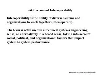
e- Government e- Government e- Government e- Government e- Government Technical Interoperability Technical Interoperability Technical Interoperability Technical Interoperability Technical Interoperability Inter-community Interoperability Inter-community Inter-community Inter-community Inter-community e- Land Administration e- Land Administration e- Land Administration e- Land Administration e- Land Administration Legal Interoperability Legal Interoperability Legal Interoperability Legal Interoperability Legal Interoperability Semantic Interoperability Semantic Interoperability Semantic Interoperability Semantic Interoperability Semantic Interoperability Interoperability aspects in e-Land Administration Organizational • Semantic interoperability represents harmonized terminology and interpretation of concepts • Legal interoperability develops directives, rules, parameters and instructions for managing business work flow considering information and communication incorporation in the business • Inter-community interoperability includes ensuring consideration of providing a unique portal to perform various tasks and application in land administration. • Technical interoperability is the development of standard communication, exchange, modelling and storage of data information as well as access portals and interoperable web services equipped with user-friendly interfaces. Technical (Kalantari, 2005)
Interoperability Toolkit in e-Land Administration • Data management tools: To facilitate and manage the development or intensification land information from multiple distributed sources. • Enterprise architecture design tools: To facilitate and support development of plug-and-play Enterprise Systems and Architectures using a Web-based Foundation • Access and sharing tools : To facilitate the development of a web-based access in a seamless and integrated view • Decision support and exploitation tools : To facilitate decision-support applications that draw on multiple, distributed spatial data resources Cadastral Data Modelling
Client Client Client Client Client Client Client Client Client Business Logic e- Application Business Logic e- Data lodgment Business Logic e-Conveyancing Business Logic e- Land taxation Business Logic e-Data lodgment e-Conveyancing e-Land taxation Access Access Access Access Data Access Cadastral Data Model e-Land Administration Environment Land administration subsystems Custodian Custodian Custodian Custodian Custodian Custodian Custodian Custodian Cadastral Database Reference Cadastral Data Model forInteroperable e-Land Administration
Current Cadastral Data Model Land Mapping Land Registration Land Valuation Land Development User Requirements Parcel Title Property Owner
Cadastral Data Model based on the Paradigm Land Up-Surface-Under RRRs Land Mapping Land Registration Land Valuation Land Development User Requirements Parcel Parcel Title Property: Building Water Carbon …. Person: Public Natural non -Natural Property Owner Address
Conclusion 1: Research Problem The current cadastral data model does not effectively provide interoperability among land administration subsystems and cannot facilitate delivering sustainable development.