Download
1 / 18
180 likes | 295 Views
LUCID La nd- U se and C limate: ID entification of robust impacts. Nathalie de Noblet, Andy Pitman nathalie.de-noblet@cea.fr. Year 1992. 40% of the land is nowadays intensively used for anthropogenic activities. year 1700. Maps obtained combining 2 datasets: Ramankutty & Foley (1999),

E N D
LUCID Land-Use and Climate: IDentification of robust impacts Nathalie de Noblet, Andy Pitman nathalie.de-noblet@cea.fr
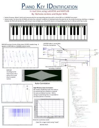
Year 1992 40% of the land is nowadays intensively used for anthropogenic activities year 1700 Maps obtained combining 2 datasets: Ramankutty & Foley (1999), Goldewijk (2001) Fraction of each 1°*1° grid-cell occupied by crops
Has (will) the perturbation of biophysical variables and of fluxes exchanged at the land/atmosphere interface induced by the anthropogenic land-cover changes in a context where atmospheric CO2 is increasing significantly modified (modify) atmospheric and/or oceanic circulation?
LAI : Indice Foliaire LAI : Indice Foliaire 6 6 5 5 4 4 3 3 2 2 1 1 0 0 50 50 100 100 150 150 200 200 250 250 300 300 350 350 days days winter crop natural grassland a different partitioning of energy and water Foley, 2003 a change in the timing of the seasonal cycle Gervois et al. 2005
From pre-industrial times + 1,5 W/m2 - 0,26 W/m2 Contribution to the global radiatif forcing a) CO2 (red) and b) land-surface albedo (green) PhD Edouard Davin (in progress)
We know (1) from meso-scale studies that land-use induced land-cover changes have a large impact on the meso-scale atmospheric circulations
in 1993, natural wetlands are replaced by crops in South Florida Marshall et al., Nature 2003
in 1997, a rare freeze inflicted severe damage in these new agricultural regions Has the conversion of wetlands increased the incidence and severity of damaging freezes? Natural vegetation Pre-1900 Actual vegetation Post-1993 Changes in biophysical parameters of the land Regional atmospheric model - RAMS Region atmospheric model - RAMS Differences Impact of land-cover changes
Effect of land-use induced land-cover changes on temperature and duration of below-freezing events °C minutes Temperatures are colder after having drained the wetlands Longer duration of below-freezing events Marshall et al., Nature 2003
We know (2) from large-scale studies using models of intermediate complexity that biophysical impacts of land-use induced land-cover changes have cooled down the climate, partially counteracting the effects of increasing atmospheric CO2
Many models of intermediate complexity have seen the same deforestation scenarios over the past 1000 years in all models: deforestation global and annual cooling of the northern hemisphere Brovkin et al., Climate Dynamics 2006
This global cooling mainly comes from the high latitudes, and results from an increased surface albedo zonal + annual mean surface temperature (°C) zonal mean surface albedo Brovkin et al., Climate Dynamics 2006
During this same time period, atmospheric CO2 increases CO2 and leads to the well-known ‘climate warming’ Brovkin et al., Climate Dynamics 2006
The combined effects of deforestation and increased CO2 have led to a cooling until ~1900 followed by a warming Brovkin et al., Climate Dynamics 2006
But there is no consensus on • the magnitude of the global scale cooling • the spatial distribution of that global scale cooling • the potential changes induced on modes of atmospheric variability, extremes, interannual and decadal variability + all (except Hadley Centre) simulations within IPCC AR4 do not account for land-use induced land-cover changes
So we have decided to start a model intercomparison project (MIP) • snap-shot experiments (pre-industrial and present-day) forced with the same observed SSTs, SICs, CO2 and crop/pasture distribution • ensemble simulations (6 to 10 members) • transient simulations from 1870 to 2002 forced with the same observed SSTs, SICs, CO2 and crop/pasture distribution (within the C20C project) • transient simulations from 1850 till 2100 with computed SSTs and SICs (within the European ENSEMBLES project)
Project endorsed by IGBP – iLEAPS And GEWEX-GLASS
So far • 6 groups have started to run some or all experiments: • Meteo-France (Aurore Voldoire) … all • LSCE (Nathalie de Noblet) … all • Macquarie University (Andy Pitman) … snapshots • Université de Montpellier (Christine Delire) … snapshots • NCAR (Gordon Bonan) … all • COLA (Maggie Zhao) … transient with prescribed SSTs (C20C) • set-up a distribution list and a DODS server lucid@dsm-mail.saclay.cea.fr http://dods.extra.cea.fr/data/p25nath/DIVA/ForcingData/ • written a first draft of the protocol … there are still some open questions (merging of crop/pasture map with each model’s land-cover map; leaf area index prescribed in some models, computed in others!, some models still are not able to update their land-cover map regularly/yearly…)