Download
1 / 30
310 likes | 741 Views
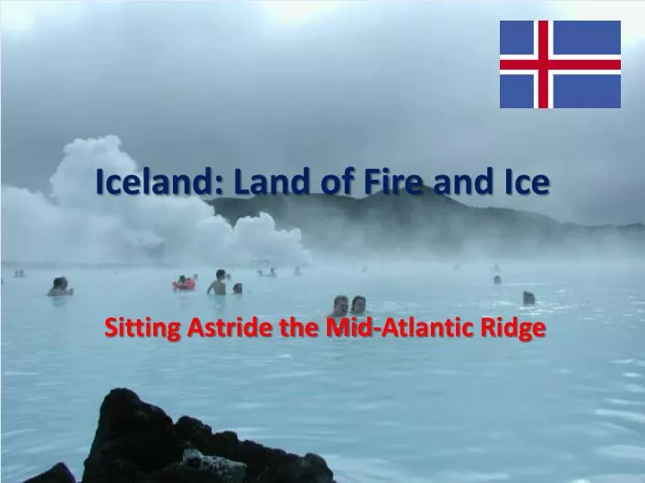
Iceland: Land of Fire and Ice. Sitting Astride the Mid-Atlantic Ridge. The only place where the Mid-Atlantic Ridge rises above sea level. The Mid-Atlantic Ridge (Divergent tectonic plate boundary) attracts tourists. Volcanic Activity.

E N D
Iceland: Land of Fire and Ice Sitting Astride the Mid-Atlantic Ridge
The only place where the Mid-Atlantic Ridge rises above sea level.
The Mid-Atlantic Ridge (Divergent tectonic plate boundary) attracts tourists.
Volcanic Activity • Volcanic eruptions are far more frequent on convergent tectonic plate boundaries (Cascade Mountain Range & the Andes) than on divergent tectonic place boundaries (Iceland); however, eruptions do occur along divergent boundaries. Recently and eruption broke through the icecap in Iceland.
Iceland’s Eruptions • Ash and roughly thirty-story-tall lava fountains shoot from a half-mile-long (0.8-kilometer-long) rupture in the icy cap of southern Iceland's Eyjafjallajokull (pronounced AY-uh-full-ay-ho-kul) volcano early Sunday. • The geology of Iceland, though, is anything but normal. The volcanic island lies just south of the Arctic Circle atop the Mid-Atlantic Ridge, where two tectonic plates are forever pulling apart. Magma from deep inside Earth rushes upward, filling the gaps and fueling Iceland's volcanic eruptions, which occur about once every five years.
From a different angle, Eyjafjallajökull's "lavafall" appears unobstructed by billowing steam, revealing the glowing yellow ribbon cascading down the rocky gorge on March 26, 2010.
Lava spraying high into the air draws crowds of tourists to Iceland's Eyjafjallajökull volcano on March 27, 2010. When the eruption started on March 21, hundreds of people were evacuated from their homes, due to fears of flooding, which could have occurred, had the volcano's heat melted too much surrounding glacial ice.
Comparison • These eruptions tend to be much less violent and destructive than those of strato-volcanoes that form near convergent boundaries. • 1980 when Mt. St. Helen erupted in the Cascade Mountains, nearly half of the mountain was blown away. • In Iceland the magma comes up to fill in a gap created by the separating of the two tectonic plates.
Not far from Eyjafjallajokull glacier, the much larger Mýrdalsjökull glacier (check the map on the next slide) hides the fiery, gently sloping Katla volcano that lies under the ice.
Krafla Volcano - Iceland An incandescent basaltic lava flow winds its way downslope from a vent at Krafla volcano in Iceland in 1984. The flow originated from an 8.5-km-long fissure that was initially active along its entire length. The fissure was produced by rifting along the mostly submarine Mid-Atlantic Ridge where it rises above sea level and cuts across the island of Iceland, forming an accessible natural laboratory for studies of episodic eruptions at this oceanic spreading ridge.
Iceland Info. • Area: 103,000 sq km • Coastline: 4,970 km • Terrain: mostly plateau interspersed with mountain peaks, icefields; coast deeply indented by bays and fiords • Land use: • arable land: 0.07% • permanent crops: 0% • other: 99.93% (2005) • Natural resources: fish, hydropower, geothermal power, diatomite
Demographic s • Population: 306,694 (July 2009 est.) • Age Structure: 0-14 years: 20.7% • Population growth rate: 0.741% (2009 est.) • Urban population: 92% (2008) • Infant mortality rate: 3.23 deaths/1,000 live births • Life expectancy at birth: 80.67 years • Adult literacy: 99%
Economy • GDP - per capita (PPP): $39,800 (2009 est.) • $42,800 (2008 est.) • $42,600 (2007 est.) • GDP - real growth rate: -6.3% (2009 est.) • 1.3% (2008 est.) • 5.5% (2007 est.) • GDP - composition by sector: • agriculture: 5.2% • industry: 24% • services: 70.8% (2009 est.)
A river with volcanic black sand banks meanders to the sea through farm fields near the southern coast of Iceland.
Looking across the plate boundary from the European Plate to the N. American