Download
1 / 96
1.02k likes | 1.78k Views
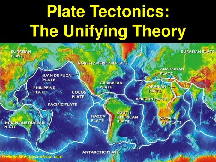
Plate Tectonics: The Unifying Theory. Peter W. Sloss, NOAA-NESDIS-NGDC. Fundamental concept of geoscience Integrates from many branches First suggested based on geology and paleontology Fully embraced after evidence from geophysics. Plate Tectonics.

E N D
Plate Tectonics:The Unifying Theory Peter W. Sloss, NOAA-NESDIS-NGDC
Fundamental concept of geoscience Integrates from many branches First suggested based on geology and paleontology Fully embraced after evidence from geophysics Plate Tectonics
• Distribution of earthquakes and volcanoes • Relationship of age and height of mountain belts • Age distribution of oceanic crust • Magnetic information in rocks What tectonics theory explains
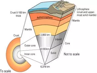
Earth’s upper mantle (lithosphere) is broken into rigid plates which move with respect to each other Plates rest on and move in the asthenosphere There are 3 kinds of plate margins that are marked by earthquakes and volcanoes Divergent Convergent Transform The movement is driven by uneven distribution of heat within Earth and the mechanism that drives plate movement is not well known What is Plate Tectonics Theory?
Mosaic of Earth’s Plates Peter W. Sloss, NOAA-NESDIS-NGDC
Theory evolved from 2 concepts: • Continental Drift - by Alfred Wegener • Fit of continents - Pangaea • Ancient climatic evidence - glacial deposits • Fossil evidence - Glossopteris & Mesosaurus • Matched mineral zones & mountain chains • (Problem - no acceptable method of motion)
ANDPALEOMAGNETIC EVIDENCE • Polar Wandering - either • the North Pole or the continents had moved • both Europe and North America had apparently moved as a single continent for several hundred million years
Seafloor Spreading • “Geopoetry” of Harry Hess & Robert Dietz • New seafloor forms by upwelling at the center of MOR and moves laterally • Older crust is destroyed in the subduction zones at the trenches • Seafloor is younger than 200 MY • Solved Continental Drift problem
Modern Proof of Seafloor Spreading • Deep Sea Drilling Project - sampled sea floor sediment & crust • Age & thickness increased with distance from MOR • Ages were symmetrical about MOR • Magnetic Anomalies - found weak & strong signal • Alternating normal & reversed polarization • Stripes || to & symmetrical about MOR
Age of Seafloor Crust Fig. 20.11 R. Dietmar Muller, 1997
More Proofs • Hot Spots - deep, long-lived, stationary mantle magma sources • Expressed at the surface by: • linear chain of volcanoes • aged with distance from hot spot • Over 100 identified • Used as fixed points against which plate motion is measured
Group of rocks all moving in the same direction Can have both oceanic and continental crust or just one kind Plate interior are relatively quiet Most activity is located at plate margins I. Plates
• divergent: mid-ocean ridges • convergent: collision zones volcanic arcs • strike-slip: San Andreas Fault Alpine Fault, N.Z. II. Types of plate boundaries
Usually begin within continents as hot spot burns thru crust and eventually grows to become ocean basin Two kinds of divergent margins Mid Ocean Ridges (MOR) Continental Rift Valleys A. Divergent plate boundaries
• Central rift valley (width is inversely proportional to the rate of spreading) • Region of high heat flow Shallow-focus earthquakes • Almost exclusively basalt volcanism Features of Mid Ocean Ridges
Rifting and Seafloor Spreading Along the Mid-Atlantic Ridge Peter W. Sloss, NOAA-NESDIS-NGDC
• East Africa, Rio Grande rift • Beginning of ocean formation (may not get that far) • Rifting begins at a triple junction (two spreading centers get together to form ocean basin, one left behind). • Rock types: basalt and sandstone Features of Continental Rifts
Hot Spot induced rifting • Hot spot burns thru crust -> 3 branched rift • Divergence begins • 2 branches are active • 1 branch is not active • Linear sea develops
Inception of Rifting Along theEast African Rift System Peter W. Sloss, NOAA-NESDIS-NGDC
Nile Delta Gulf of ‘Aqaba Gulf of Suez Red Sea Earth Satellite Corp.
The Gulf of California Formed by Rifting of Baja California from Mainland Mexico Worldsat International/Photo Researchers
New crust created at MOR—old crust destroyed (recycled) at subduction zones 2 kinds: subduction & collision Relative important densities: continental crust ≈ 2.8 g/cm3 oceanic crust ≈ 3.2 g/cm3 asthenosphere ≈ 3.3 g/cm3 B. Convergent boundaries
Three types: ocean–ocean Philippines ocean–continent Andes continent–continent Himalaya Convergent boundaries
Island arcs: Chain of volcanic islands • Highly seismic tectonic belt of shallow to deep earthquakes • High heat flow arc of active andesitic volcanoes • Bordered by a submarine trench Ocean–Ocean
Continental arcs: • Magmatic belt of active volcanoes (andesite to rhyolite) • Often accompanied by compression of upper crust which builds mountains Bordered by a submarine trench Ocean–Continent
Continent–continent boundaries, convergence is accommodated by • Folding (shortening and thickening) • Strike-slip faulting • Underthrusting (intracontinental subduction) Continent–Continent
• Product of the collision between India and Asia. • Collision began about 45 M yr. ago, continues today. • Before collision, southern Asia looked something like the Andes do today. Himalayas and Tibetan Plateau
Mostly obtained from magnetic anomalies on seafloor Slow spreading: 3 cm/year Fast spreading: 10 cm/year Very fast spreading: 17cm/year III. Rates of plate motion
Relative Velocity and Direction of Plate Movement Data from C. Demets, R.G> Gordon, D.F. Argus, and S. Sten, Model Nuvel-1, 1990
Each plate tectonic environment produces a distinctive group of rocks. By studying the rock record of an area, we can understand the tectonic history of the region. IV. Rock assemblages and plate tectonics