Download
1 / 22
220 likes | 316 Views
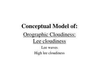
Conceptual Model of:. Wave. Cloud Structure in Satellite Image. Typical cloud configurations. Cloud bulge at rearward edge of frontal cloud band Bright in all three channels Sometimes rearward edge of cloud bulge translucent in VIS Rather smooth texture

E N D
Conceptual Model of: Wave
Typical cloud configurations • Cloud bulge at rearward edge of frontal cloud band • Bright in all three channels • Sometimes rearward edge of cloud bulge translucent in VIS • Rather smooth texture • Often in WV black stripe indication an eddy wave
Development of cloud bulge to cloud spiral and further to occlusion spiral initial occl. stage wave stage
Basic ideas:Development of cloud bulge and spiral through effect of vorticity
Conveyor Belt Theory:Lower layers • Warm conveyor belt • rising in area of wave • Upper relative stream • at the rear of the cloud band and wave bulge • Saddle point in upper relative stream • immediately south, southweast of wave bulge • rising to the N, • sinking to the S u.r.s w.c.b
Conveyor Belt Theory:Upper layers • Warm conveyor belt • rising • more to the leading edge of the cloud band • Upper relative stream • partly superimposed on wave bulge • responsible for cloud dissolution • distinct feature in WV: black stripe overrunning frontal cloud u.r.s w.c.b
frontal cloud wave cloud Selection of relevant isentropic surface:
u.r.s w.c.b saddle point
Key Parameters:Relevant numerical parameters and their typical distribution
Surface low and temperature advection Surface minimum: • Surface minimum low: • in the area of the cloud bulge • Zeroline of TA • crosses cloud bulge: • Juxtaposition of WA - CA maxima • WA maximum within cloud bulge • CA maximum immediately behind in cold air WA L CA
L WA CA
Upper level height and vorticity advection • Upper level trough • behind cloud feature • PVA maximum • partly superimposed on cloud bulge • partly behind PVA max
L PVA
Important features: • WA maximum: • within cloud bulge of wave • PVA maximum • superimposed on cloud bulge • partly behind, in CA
WA maximum: W PVA maximum: P W P
Typical weather events • Increasing widespread precipitation • Possibly thunderstorms in the area of the PVA • Most intensive precipitation to be found in the area of the emerging low cloud • Increasing surface winds; ev. Stormy winds