Download
1 / 26
270 likes | 282 Views
Mining Changing Patterns in Satellite Image Time Series. Thales Sehn Korting http://www.dpi.inpe.br/~tkorting/. Advisors Leila Fonseca Gilberto Câmara Angela Schwering. Background. Remote Sensing Data Mining Image Processing Multitemporal Images Bio Computer Engineer (FURG)

E N D
Mining Changing Patterns in Satellite Image Time Series Thales Sehn Korting http://www.dpi.inpe.br/~tkorting/
Advisors • Leila Fonseca • Gilberto Câmara • Angela Schwering Background • Remote Sensing • Data Mining • Image Processing • Multitemporal Images • Bio • Computer Engineer (FURG) • MsC in Applied Computing (INPE) • PhD candidate in Remote Sensing (INPE)
Understand patterns of change in local and global scale What is the impact of human-induced land cover change? How are ocean, atmosphere and land processes coupled? Where are changes taking place? How much change is happening? Who is being impacted by the change? Science challenges (Kumar, 2001) (Câmara, 2008)
Warning 1 Loss > 50% Warning 2 Loss > 90% Warning 3 Can we detect deforestation before it is too late? time (Câmara, 2009)
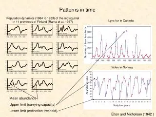
Changes in different time-scales (Heas, 2005)
Changes in geographical objects (Goodchild, 2007)
We focus on stationary objects. (Goodchild, 2007)
SITS SITS – Satellite Image Time Series 06/2008 07/2008 08/2008
SITS road construction deforestation deforestation t1 t2 t3 Detect changes What? When? Where?
Variations in image attributes define temporal signatures. NDVI ≠ Temporal resolutions
Signature for deforestation Similar signatures define changing patterns. (Freitas, 2008)
Image objects • Pixels • Cells • Regions What attributes that best describe changing patterns? (Kumar, 2001)
Transformation Classification Algebra Visual Interpretation
Hypothesis Classification methods based on data mining are efficient to identify temporal signatures.
Data Mining • Traditional techniques are unsuitable due • Large-scale • High dimensional • Heterogeneous • Complex data Data Mining Statistics AI, M. Learning, P. Recognition data bases
Data Minining Challenges • Take advantage of spatial and temporal correlation • Volume of information • 250m x 250m grid → about 10 billion for the globe • Earth Science data sets are constantly increasing • High Dimensionality • Long time series are common in Earth Science
Decision trees to classify changes • Independence of • number of attributes • amplitude of attributes • Easy to understand the result
Objective Provide a technological framework to identify land use/cover changing patterns.
Timeline Visualization Mining Extended GeoDMA framework
Mining Changing Patterns in Satellite Image Time Series Thales Sehn Korting http://www.dpi.inpe.br/~tkorting/