Download
1 / 27
270 likes | 358 Views
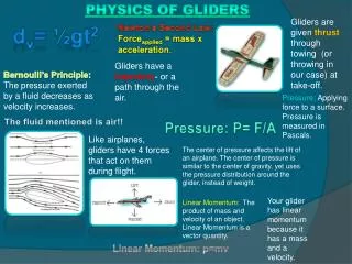
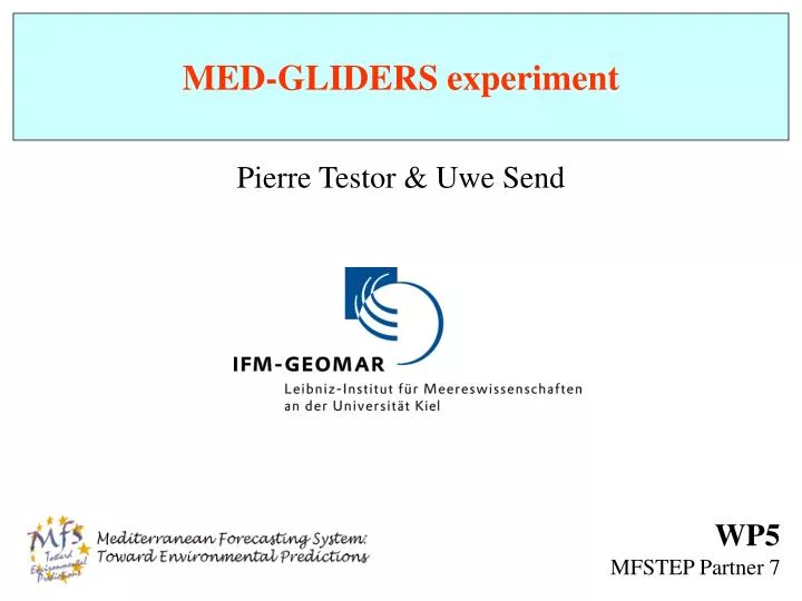
MED-GLIDERS experiment. Pierre Testor & Uwe Send. WP5 MFSTEP Partner 7. Gliders are driven by positive and negative buoyancy created by a change in volume. No propeller is required. Wings convert vertical velocity into forward velocity. Glide downward when denser than surrounding water

E N D
MED-GLIDERS experiment Pierre Testor & Uwe Send WP5 MFSTEP Partner 7
Gliders are driven by positive and negative buoyancy • createdby a change in volume. No propeller is required. • Wings convert vertical velocity into forward velocity. • Glide downward when denser than surrounding water • and upward when buoyant, in a sawtooth pattern. Control of : buoyancy and internal mass distribution effect on vertical velocity, roll and pitch Control of : angle of descent/ascent and direction
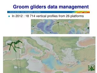
General objectives of WP5 Explore the capabilities of gliders by operating one real-time continuous glider repeat-section feeding the overall system 1/Evaluate and choose which of the available gliders prototype should/could be used 2/Determine the optimal application, capabilities and mission parameters in the MFSTEP application 3/Develop a real-time data dissemination system for glider data 4/Obtain data from the unattended glider repeat transects along one section in the Mediterranean 5/Disseminate real-time data to the community and to the forecasting system during the TOP 6/Analyze the data and assess the value of gliders 7/Establish a European capability for operating gliders
local support base : CNR-IST (Messina) C B VOS XBT network A Priority to section A with a deep glider (0-1000 m) : 800 km + 800 km = 40-80 days ~3-4 autonomous repetitions of the section in 6 months (TOP phase)
MFSTEP-WP5 Planning Pre - TOP TOP Post - TOP
TASK 5100 : Months 1- 6 study of the optimal type application capabilities / mission parameters • UW glider • Scripps glider • Webb Res. Powered Glider - speed - descent/ascent angle - max depth - sampling intensity - time spent at surface - two-way communication options - scientific objectives / observations needed - bathymetry and expected currents - capabilities and endurance of the glider - location of land base - small-ship access to part of gliders tracks for comparison measurements
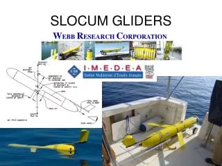
Operating Gliders Slocum Thermal, Webb Research Corp. (WRC) Spray, Scripps Institute of Oceanography (SIO) Slocum Littoral, Webb Research Corp. (WRC) Seaglider, University of Washington (UW)
Legacy Glider Specifications : Extended capacities Electric glider 1000 m depth Based on the WRC coastal version • “Training period” • at Webb Res., Falmouth, US, Oct. 2003 • Observational Meeting • at ENEA, Santa Teresa, Italy, Oct. 2003 • - Glider ready for tests in may 2004 Weight: 52 Kg Vehicle Length: 1.5 meters Shape: Cylindrical to Laminar Depth Range: 75 – 1000 meters Speed: 0.25 - 0.45 m/sec horizontal Energy: Alkaline Batteries Nominal Payload: 4 Kg Endurance: Weeks to Months Range: 1000 - 7000 km Navigation: GPS, Attitude Sensor, Pressure, Altimeter Communications: RF modem, Iridium, ARGOS, Acoustic modem Steering & Attitude: Mass shift, Control surfaces
YO Sampling Starting Point Waypoint (Lat, Lon) GPS, Iridium GPS, Iridium 4 - 10 km surface 1000 m 1) Waypoint (lat, lon) – distance to waypoint 2) Angle of ascent/descent 3) Max depth 4) Nb of YOs between sat. comm. z 20-40 cm/s keep its course towards waypoint
YO Sampling y No oceanic currents x Way Point (Lat, Lon) Starting Point GPS, Iridium distance to waypoint is reached (internally estimated) = end of mission, wait for new instructions 1) Way point (lat, lon) – distance to waypoint 2) Angle of ascent/descent 3) Max depth 4) Nb of YOs between sat. comm.
YO Sampling y Starting Point GPS, Iridium x Way Point (Lat, Lon) GPS, Iridium GPS, Iridium GPS, Iridium 1) Way point 2) Angle of ascent/descent 3) Max depth 4) Nb of YOs between sat. comm. Mean current along glider YO
YO Sampling y Starting Point x Way Point (Lat, Lon) GPS, Iridium GPS, Iridium GPS, Iridium option to take into account previously measured currents to target the waypoint 1) Way point 2) Angle of ascent/descent 3) Max depth 4) Nb of YOs between sat. comm. Mean current along glider YO
local support base : CNR-IST (Messina) List of waypoints VOS XBT network WPT2 A WPT1 Endurance of several months : only expected numbers ! By now, maximum proven endurance for coastal glider without batteries change = 22 days (< 80 days needed)
local support base : CNR-IST (Messina) VOS XBT network 800 km New track ? Similar endurance for coastal and deep gliders By now, we can expect to achieve a section < 300 km + 300 km Maintenance operations every ~ 30 days near Messina (a lot of ship time even with small boats)
Gliders are still “teenagers” To reach the goals of the project : increase significantly the endurance/range… Solution : upgrade alkaline to lithium batteries Other Solutions : 1) sampling optimization 2) use of our knowledge of the currents 3) vertical velocity control, compensators
Sampling - Present and Planned Sensor Packages: ADCP Acoustic Modem Altimeter Bathyphotometer (bioluminescence) Optical Backscatter Optical Attenuation Oxygen Conductivity, Temperature, Depth Fluorometer Hydrophone & Towed Arrays Oxygen PAR sensor Spectrophotometer (red tide detection) multidisciplinarity Lowest energy cost
The glider records 3 kinds of files Storage and download during recovery/maintenance cruises only sampling rate 6 s ~ 1 m along vertical • Log files • Data files • - Short data files fewer levels for data transmission in near real time via Iridium (10 min for sat. comm.) save satellite communication time (energy) and avoid collisions with boats, nets, biofouling
Sampling - Data transmission in NRT Short data files missions 2 GPS fixes > 100 levels of T and S 1.5 min GPS 8 min Iridium 1.5 min GPS 11 minutes ~ 6 km, 4-8 hours surface 25º Levantine Waters 700 m z angle of ascent/descent = 25 º (minimum energy cost)
Gliders are still “teenagers” To reach the goals of the project : increase significantly the endurance/range… Solution : upgrade alkaline to lithium batteries Other Solutions : 1) sampling optimization 2) use of our knowledge of the currents 3) vertical velocity control, compensators
Use of our knowledge of the currents/modification of the section During the TOP phase : Forecast bulletins > estimations of U and V fields < 3 km 25º 1000 m U x z > 3 km 25º 1000 m U x z The section will certainly not be a straight line…
To pilot the glider • help of • - MFSTEP forecasts, • Simulations of the glider flight • in the model outputs Estimation of waypoints rectilinear trajectory
Gliders are still “teenagers” To reach the goals of the project : increase significantly the endurance/range… Solution : upgrade alkaline to lithium batteries Other Solutions : 1) sampling optimization 2) use of our knowledge of the currents 3) vertical velocity control, compensators
Vertical velocity control ~3 km 25º 700 m x z Buoyancy pump action, now 25º 700 m x z Buoyancy pump action, projected + Use of compensators to approach the compressibility of seawater
local support base : CNR-IST (Messina) VOS XBT network - Sequence of tests at Webb Res. facilities - Cruise in June-July 2004 near Messina with R/V Sanzo 15 days of final tests Glider ready (upgraded) for the TOP
local support base : CNR-IST (Messina) VOS XBT network 1st step of the TOP phase ~1 month
local support base : CNR-IST (Messina) VOS XBT network etc…
local support base : CNR-IST (Messina) VOS XBT network 800 km • New track ? Data assimilation needs ? • ~ 600 km • Orthogonal to XBT lines ? • Monitoring exchanges between western and eastern basins ? • Territorial waters (12 miles) ?