Download
1 / 7
70 likes | 180 Views
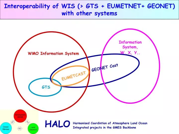
Interoperability of WIS (> GTS + EUMETNET+ GEONET) with other systems. Information System, W, X, Y. WMO Information System. GEONET Cast. EUMETCAST. GTS. Potential for future developments of GMES and WMO Info Systems (i).

E N D
Interoperability of WIS (> GTS + EUMETNET+ GEONET) with other systems Information System, W, X, Y.. WMO Information System GEONET Cast EUMETCAST GTS
Potential for future developments of GMES and WMO Info Systems (i) • HALO recommends optimisations for the interactions between the GMES atmosphere, land, and ocean monitoring systems, which are mainly the global modelling and data assimilation activities. • The EU-funded SIMDAT/MET software will be used by WMO partners to implement Europe-wide WIS capabilities • The EU-funded SIMDAT/MET software can also be used by GMES partners to implement WIS-like capabilities for GMES • Substantial benefits for all users could be achieved thru direct collaboration between GMES & WMO on a shared system • WMO welcomes collaborations with communities such as GMES to share / develop WIS capabilities • A joint effort by GMES partners and European WIS partners would accelerate the implementation of a joint Europe-wide GMES/WIS information system
Potential for future developments of GMES and WMO Info Systems (ii) • A joint effort by GMES partners and European WIS partners would accelerate the implementation of a joint Europe-wide GMES/WIS information system • Such extensions will require • Negotiation of certification with WMO system • New software (adapters) to provide access to own data repositories • Implementation of metadata standards to describe data and data policy • Implementation of virtual organisation to address security issues – authentication, authorisation, data policy… • Implementation of physical infrastructure to connect to GISC • Et cetera…..
Schedule to completion Candidate Solutions • July Agree the main principles of the report • Sep 15 Text on Halo Reqts. + Text on WIS • Oct 15 Use of WIS by MERSEA /GEOLAND /GEMS (i) • Nov 15 Use of WIS by MERSEA /GEOLAND /GEMS (ii) • Dec 4-5 Workshop (@ECMWF) • Agree overall recommendations + report • Jan 15-30 Final report Science Land Issues • Fires • Validation of surface flux estimates • Off-line products • Ocean Issues • Forecast forcing fields • Fluxes • Carbon cycle • Seasonal forecasting
political characteristics • Ease of access for European institutions? • Global reach? • Low cost? • Easy implementation of data policies? • Flexibility to serve new customers? • technical characteristics • Capacity/throughput? • Reliability? • Adaptability to new requirements /upgradability? • Accepted technical standards, globally and within Europe? • Efficiency • Efficiency for HALO/GMES data flows • Efficiency for core product exchange? • Efficiency for satellite data acquisition? • Efficiency for in-situ data acquisition? • Is the service suitable for operational use?
Issues from industrial partners • Can satellite broadcast be extended with terrestrial networks? • Does the service provide dissemination only? • Does the service manage data exchange, user access..? • Max data rate? • Does the service ensure secure access to data..? • What are the commitments on delivery time? • Is the data transfer to the uplink station an issue? • Suitability for a small number of core services? • What are the access restrictions? • What are restrictions on data representation (format)? • Is the service suitable for operational use?
GMES & WMO Information Systems A.Hollingsworth, A. Hofstadler, B. Raoult, J.Kaiser, Y. Desaubies, M. Leroy, J.-C. Calvet, M. Tinz, F. Levy, J.-M. Pechinot, D. Schiessl ECMWF, IFREMER, MEDIAS-France, METEO-France, Infoterra, Astrium, Alcatel, WMO