Download
1 / 8
91 likes | 369 Views
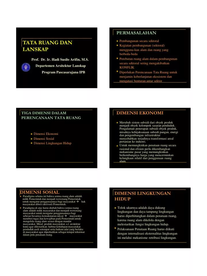
PERMASALAHAN. Pembangunan secara sektoral Kegiatan pembangunan (sektoral) mengguna-kan alam dan ruang yang berbeda-beda Perebutan ruang alam dalam pembangunan secara sektoral sering mengakibatkan KONFLIK Diperlukan Perencanaan Tata Ruang untuk menjamin keberlanjutan ekosistem dan

E N D
PERMASALAHAN Pembangunan secara sektoral Kegiatan pembangunan (sektoral) mengguna-kan alam dan ruang yang berbeda-beda Perebutan ruang alam dalam pembangunan secara sektoral sering mengakibatkan KONFLIK Diperlukan Perencanaan Tata Ruang untuk menjamin keberlanjutan ekosistem dan mengatasi benturan antar sektor TATA RUANG DAN LANSKAP Prof. Dr. Ir. Hadi Susilo Arifin, M.S. Departemen Arsitektur Lanskap Program Pascasarajana IPB DIMENSI EKONOMI TIGA DIMENSI DALAM PERENCANAAN TATA RUANG Merubah sistem subsidi dari obyek produk menjadi obyek kelompok sasaran penduduk. Pengalaman penerapan subsidi obyek produk, misalnya kebijaksanaan subsidi pangan, energi dan pengembangan infrastruktur Dimensi Ekonomi menyebabkan terjadinya transformasi areal pertanian ke industri. Untuk memungkinkan penataan ruang secara Dimensi Sosial Dimensi Lingkungan Hidup rasional dan efisien perlu dikembangkan mekanisme pasar yang memungkinkan berkembangnya harga yang mencerminkan kelangkaan relatif dari penggunaan ruang alam. DIMENSI SOSIAL Paradigma selama ini bahwa semua ruang alam adalah milik Pemerintah dan menjadi wewenang Pemerintah untuk mengatur penggunaannya bagi masyarakat hak masyarakat diberi (derived) Pemerintah. DIMENSI LINGKUNGAN HIDUP Tolok ukurnya adalah daya dukung lingkungan dan daya tampung lingkungan harus diperhitungkan dalam penataan ruang, karena ruang alam dikelola dengan melestarikan fungsi lingkungan hidup. Pelaksanaan Penataan Ruang harus diikuti dengan internalisasi eksternalitas lingkungan ini melalui mekanisme retribusi lingkungan. Paradigma di atas harus diubah bahwa semua ruang alam adalah milik masyarakat dan menjadi wewenang masyarakat untuk mengatur penggunaannya bagi sebesar-besarnya kemakmuran rakyat masyarakat memberi tugas dan kewajiban pada Pemerintah untuk mengelola ruang alam sesuai dengan mandat masyarakat. Misal: produk masyarakat, a.l. arsitektur kuno agar dilestarikan; habitat kehidupan masyarakat penduduk aseli setempat serta hukum adat yang berlaku di masyarakat agar diperhatikan sebagai tempat tehormat dalam pola penataan ruang.
KONFLIK PENGGUNAAN RUANG DISEBABKAN: Transformasi struktur perekonomian dari yang bersifat agraris ke struktur Pertumbuhan ekonomi telah meningkatkan permintaan terhadap ruang, sedangkan ketersediaannya relatif tetap: pembangunan kota-kota baru di Jabotabek; harga tanah meningkat secara kurang rasional misal, pada perekonomian yang relatif bersifat industri: secara langsung mengaki-batkan terjadinya dorongan terhadap alih fungsi ruang dari periode 1989-1993 harga tanah di jabotabek meningkat 71% per tahun. Setiap tahunnya hutan Indonesia berkurang sekitar 600,000 ha, yang berarti merupakan 20% dari deforestasi di dunia. penggunaan pertanian ke non-pertanian. Meningkatnya resiko dan ketidak tentuan (uncertainty) akibat ketidak jelasan Meningkatnya jumlah dan mobilitas penduduk: Populasi penduduk Indonesia 212 juta (1998), pertambah-an 4 perkembangan ekonomi. Adanya tuntutan-tuntutan masyarakat terhadap berbagai kekeliruan keputusan mengenai alokasi ruang yang dilakukan pada masa lalu. juta/tahun. Prediksi pada tahun 2035 penduduk Indonesia akan menjadi 400 juta. The Rural & Land Ecology Survey & Survey Integration N-4 Course ITC - BAKOSURTANAL LAND EVALUATION STUDY FOR SMALL HOLDERS UPLAND AGRICULTURE IN JAMPANG TENGAH, NYALINDUNG & CIKEMBAR SUKABUMI DISTRICT WEST JAVA - INDONESIA Prof. Dr. Ir. Hadi Susilo Arifin, M.S. Kebijakan ekonomi makro yang berorientasi ke luar (outward looking) dinilai kurang baik terhadap kebijaksanaan tata-ruang karena berdampak negatif dikarenakan: Sifat ruang sebagai komoditas semakin menonjol Fungsi penataan ruang sebagai instrumen pemerataan pembangunan antar wilayah dan pemerataan kesejahteraan antar lapisan masyarakat semakin tidak efektif Fungsi ekologis ruang semakin diabaikan. DEPARTMENT OF LANDSCAPE ARCHITECTURE THE GRADUATE SCHOOL OF BOGOR AGRICULTURAL UNIVERSITY Integrated use of the disciplines Continued...
A. PROBLEM FINDING AND SOLVING IN THE STUDY AREA OF CIKEMBAR, NYALINDUNG AND JAMPANG TENGAH SUB-DISTRICT Background of Study Area which of Problem area is stated by BAPPEDA TK II Sukabumi Land Evaluation Study Objectives A. B. Objectives of survey Selecting the study area Activities (Incl. Method, Example, etc) Information requirement M E A N S LOCAL LAND USE PLANNING through LAND EVALUATION STUDY Out Come Maps Information for LUTs C. SOURCE: - Syllabus on Information Management - Basic patern of regional development of Sukabumi District (1989/1990 – 1993/1994) LAND USE IN THREE SUB-DISTRICT (1989) INTRODUCTION BACKGROUND Problem finding in the study area Government Objectives Table. Land Use system in Sukabumi District and in Study Area SUKABUMI STUDY AREA LTA – 47 BAPPEDA VILLAGE PROFILE LAND USE 1985/1986 1989/1990 1990 1. Grassland + Bushland 2. Forest 3. Dryland 4. Wetland 5. Estate 2.2 29.8 23.8 14.4 20.2 11.6 28.2 12.1 15.2 17.6 - - 26 13.6 29 SOURCE : SUKABUMI DALAM ANGKA 1989 MATRIX OF PRELIMINARY LUT(s) AND SUB-DISTRICTS IN STUDY AREA B. LAND EVALUATION STUDY OBJECTIVES 1. BAPPEDA : to provide the contribution of local land use planning foccussing on the Agriculture aspect in the effort to support the present and future development activities SURVEY OBJECTIVES : To analyze development options & the subsequent trends in land use To analyze & assess for the survey area the nature, extent, location as well as the couses & effects of the natural resource problems and potentials To assess the present & future needs and systema- tically evaluate the land’s ability to supply them - - -
OBJECTIVES ACTIVITIES 2. In order to ensure the efficiency continuation of survey activity, work procedures are divided into three : This land evaluation study deals with upland agriculture land use addressed to small holders or small scale farmers. This land evaluation study may hopefully contribute information for spatial land use planning procedures and policies formulated by government Pre – field Work Field Work : conducted in the form of secondary & primary data collection through interview and field check and observation Post – field Work A. B. C. Three steps mentioned above is actually implemented according to land evaluation study procedures show in the scheme below : of Sukabumi District in its attempt to achieve the aim of accelerating development activities. METHODOLOGY THE MAIN OBJECTIVES ARE AS FOLLOW : METHOD PARALLEL APROACH To analyze development options and the subsequent trends in land use 1. - FIELD CHECK - INTERVIEW SEMI DETAIL SURVEY UNIT OBSERVATION - To analyze and assess for the survey area the nature, extent, location as well as the causes & effects of the natural resource problems and potentials 2. - SCALE OF MAP MATERIALS SPATIAL DATA NON SPATIAL DATA To assess the present & future needs and systematically evaluate the land’s ability to supply them DATA / INFORMATION REQUIREMENTS TO 3. 3. BE COLLECTED OUT COME 1. MAPS : Land Unit Map Land Cover Changing Map Land Suitability Map for each LUT These have been formulated after taking into account problem finding & solving in the three study area & summarized in the form of information requirement bellow Data Requirement : C. Land Suitability Map for all LUT INFORMATION for LUTs Present Condition Future Physical Data : Climate Geology Landform Hydrology Soil Vegetation Present land use Agriculture system Management & field Social-Economic Data : Market Labor Infrastructure Population Subsistence requirement Land tenure 2.
LAND EVALUATION ANALYSIS AND CLASSIFICATION RESULTS PRESENT FARMING SYSTEM Farming System Type PROMISING LUTs Farm Size Farm Income LAND COVER / USE Land Cover / Use in 1981 LUT1 LUT2 LUT3 LUT4 : : : : TEA MULBERRY ALBIZIA ALBIZIA / MAIZE Land Cover in 1989 Land Cover Changes 1981 - 1989 TERRAIN MAPPING UNIT QUALITIES LAND USE REQUIREMENT : LAND SUITABILITY CLASSIFICATION AVAILABILITY OF ROOTING SPACE Soil effective depth (cm) - - Coarse fragment (%) EROSION HAZARD - Slope (%) NUTRIENT RETENTION CAPACITY pH - AVAILABILITY OF OXYGEN Drainage class - TEMPERATURE REGIME Annual mean temperature (ºC) - MATCHING TMU & FACTOR RATINGS SUITABILITY CLASS : S1, S2, S3, N DISCUSSION CONCLUSION LAND EVALUATION STUDY Land Suitability Classification, Land Suitability Map Tea, Mulberry, and Albizia are feasible planted within study area The limiting factor of soil pH can over come by liming. The limiting factor of slope steepness can over come bay contour terracing. LAND SUITABILITY IN THE STUDY AREA THE MAIN LIMITING FACTOR Low – Soil pH, or High – Soil pH Shallow – Effective Soil Depth Verry Steep - Slope 1. 2. 3. S1, S2, S3, N for TEA S2, S3, N for MULBERRY S2, S3, N for ALBIZIA S2, N for MAIZE
CASE STUDY OF URBANIZATION LANDSCAPE CHANGES OF URBAN OPEN SPACES PLANNING To promote productivity and sustainable land use for home gardens during urbanization, it is necessary to maintain large size home gardens which permits the presence of back yard and side yards, and multi- layering. • HOME GARDENS & LAND RENT Prof. Dr. Ir. Hadi Susilo Arifin, M.S. DEPARTMENT OF LANDSCAPE ARCHITECTURE THE GRADUATE SCHOOL OF BOGOR AGRICULTURAL UNIVERSITY Susatainable Landscape Mgt/ H.S.Arifin/Dept ARL/06 • • In order to maintain a high bio-diversity of urban landscape in Indonesia, it is important to keep the role of public open spaces, i.e. community parks, cemetery, green belt and corridors of street, railway, river banks, etc. Revitalizing of greenery open spaces of Bogor Municipality to be planned through Urban Agriculture Program to increase the community income and food security as well as to realize the City Plan “Bogor as a Garden City”. Susatainable Landscape Mgt/ H.S.Arifin/Dept ARL/06 EFFECTS OF URBANIZATION • The higher urbanization level was marked by reduction in the average size of home gardens; more block and strip of home gardens pattern were appeared; more side yards and back yard zones disappeared; however, frequency of back yards were high. • According to the function of the elements, the sense of private ownership and aesthetic were predominant in the highest urbanized area. On the other hand, production function and intimate atmosphere of home gardens still remain constant in the least urbanized area. Susatainable Landscape Mgt/ H.S.Arifin/Dept ARL/06 Tabel Jumlah Penduduk, Penduduk Bermatapencaharian Utama Sebagai Petani Luas Lahan Pertanian dan Luas Wilayah Kecamatan Pancoran Mas Tahun 2000 H.S.Arifin/Dept ARL/06 It was found the most prominent effect of urbanization was the increase in ornamental species. The ratio of non-ornamental species was high in large sized home gardens, the presence of back or side yards, and a higher layer of the stratification structure, in spite of urbanization. To promote productivity and sustainable land use for home gardens during urbanization, it is necessary to maintain large size home gardens which permits the presence of back yard and side yards, and multi-layering. Susatainable Landscape Mgt/ H.S.Arifin/Dept ARL/06 Tabel Luas Penggunaan Lahan Kecamatan Pancoran Mas Tahun 1989, 1996 dan 2000 Susatainable Landscape Mgt/ H.S.Arifin/Dept ARL/06
Tata Guna Lahan Kecamatan Pancoran Mas Tahun 1989 Susatainable Landscape Mgt/ H.S.Arifin/Dept ARL/06 Perbandingan sewa Lahan (Land Rent) Antara Lahan Pertanian dan Lahan Non Pertanian Berdasarkan Nilai Rill Nilai opportunity cost = Rp 21.840.866,97 /m2/tahun Susatainable Landscape Mgt/ H.S.Arifin/Dept ARL/06 Faktor-faktor yang Mempengaruhi Nilai Sewa Lahan (Land Rent) Model Regresi : Y = 84164098,54** - 29716072,58 F1* - 11187409,15 F2 - 19591826,30 F3 - 37583069,63 F4** - 52777577,87 F5** - 22584210,60 F6 + 4524218,30 F7 - 39173437,85 F8** Tahun 1996 Susatainable Landscape Mgt/ H.S.Arifin/Dept ARL/06 Perbandingan sewa Lahan (Land Rent) Antara Lahan Pertanian dan Lahan Non Pertanian Berdasarkan Suku Bunga yang Berlaku Nilai opportunity cost = Rp 5.930.491,81 /m2/tahun Susatainable Landscape Mgt/ H.S.Arifin/Dept ARL/06 Faktor-faktor yang mempengaruhi nilai land rent : Nilai input usaha tani Nilai output usaha tani Kelas kesesuaian lahan Luas lahan usaha Biaya tetap Biaya variabel Biaya tenaga Kerja non keluarga Biaya sewa lahan Jarak antara lahan usaha dan pasar utama terdekat Y = Nilai sewa ekonomi lahan (land rent) Susatainable Landscape Mgt/ H.S.Arifin/Dept ARL/06 Susatainable Landscape Mgt/ H.S.Arifin/Dept ARL/06
Faktor-faktor yang Memberikan Pengaruh Nyata Terhadap Nilai land rent Faktor 1 Input Usaha Tani ¶ Biaya benih dan bibit, ¶ Pupuk ¶ Insektisida dan herbisida Output Usaha Tani ¶ Pengeluaran usaha tani lainnya ¶ Total pengeluaran usaha tani Luas Lahan Buah Susatainable Landscape Mgt/ H.S.Arifin/Dept ARL/06 Faktor 4 Biaya Tetap Non Sewa Lahan Biaya Sewa Lahan Biaya Variabel Non Tenaga Kerja Biaya Tenaga Kerja Non Keluarga Faktor 5 Kesesuaian Lahan Tanaman Tahunan Kelas S1 Kesesuaian Lahan Tanaman Tahunan Kelas S3 Faktor 8 Jarak Lahan Usaha dari Pasar Utama Terdekat Susatainable Landscape Mgt/ H.S.Arifin/Dept ARL/06