Download
1 / 21
250 likes | 857 Views
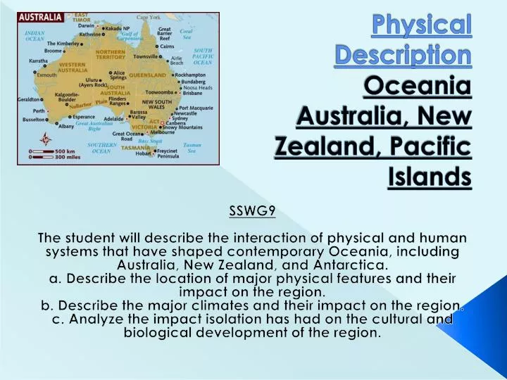
Physical Description Oceania Australia, New Zealand, Pacific Islands. SSWG9 The student will describe the interaction of physical and human systems that have shaped contemporary Oceania, including Australia, New Zealand, and Antarctica.

E N D
Physical DescriptionOceaniaAustralia, New Zealand, Pacific Islands SSWG9 The student will describe the interaction of physical and human systems that have shaped contemporary Oceania, including Australia, New Zealand, and Antarctica. a. Describe the location of major physical features and their impact on the region. b. Describe the major climates and their impact on the region. c. Analyze the impact isolation has had on the cultural and biological development of the region.
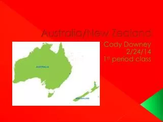
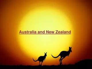
Australia/Background • Known as the Land Down Under • Reason: Australia’s location south of the equator • Country is also a continent • Smallest, flattest and 2nd driest continent • Name Australia comes from Latin word meaning “southern”
Australia/Landforms • Divided into 3 major landform regions: • Great Dividing Range(1) • Central Lowlands (2) • Western Plateau (3) • Great Dividing Range (1) • Highlands/eroded remains of old mountain range • Divides flow of Australia’s rivers • Low Great Dividing Range --- Australia’s main mountain system
Australia Landforms continued • Central Lowlands (2) • Below this area lies the Great Artesian Basin • Artesian wells: wells in which water flows naturally • Western Plateau (3) • Covers 2/3 of Australia • Contains oldest rocks on the continent • Deserts cover central area
Australia/Climate • Desert continent, warm temperatures • 2/3 of Australia has arid/semiarid climate • Long droughts followed by short/powerful storms • 2 Factors for dry climate: • Much of Australia lies about 20°-30° south latitude (1) • Low elevation (2)
Australia/Plants/Animals • Plants/animals unique here due to 35 million years of isolation • Ex: Cats, deer, cattle not native to Australia • Most mammals are marsupials • Mammals that have pouches to carry their young • Examples: kangaroo, koala, wallaby • Can find about 500 species of eucalyptus
Australia/Natural Resources • Rich in energy/mineral resources • Bauxite, copper, iron ore, uranium • Mining centers throughout Australia • Only 6% of Australia’s land suitable for agriculture • Many land areas used for grazing
The Outback • Western Australia • Temperatures can reach 120° in the shade • Only 10 inches of rainfall a year • Dust storms common • Fewer than 1% of South Australia’s 1.5 million people live here • Original inhabitants were the aborigines
Outback continued • Inhabitants of the Outback only survive by adapting to their environment • Outback home to animals such as: • Australian feral camel • Dingo • Kangaroos • Cockatoos • Popular destination --- Alice Springs • One of the Outback’s largest cities
Great Barrier Reef • Largest coral reef in the world • Located in Coral Sea off the coast of Queensland NE Australia • World’s biggest single structure of living organisms • Coral reef formed by colonies of tiny marine animals • Skeletons build up into reefs on a volcanic basis
Problems w/ Great Barrier Reef • Warming/bleaching (1) • Ocean temperatures too high, due to global warming, coral reefs become stressed • Algae in outer tissues expel • Limestone skeleton exposed • Overfishing/Cyanide fishing (2) • Divers squirt cyanide on coral reef • look for live but stunned fish • Crown of thorns sea star (3) • Poison spikes eject from stomach/eat coral
New Zealand/Background • South Pacific island 1,000 miles SE of Australia • Mountainous • Contains 2 major islands • North Island (1) • South Island (2) • Both separated by the Cook Strait • Located on Pacific Ring of Fire
New Zealand’s Islands • North Island (1) • Tectonically active • Active volcanoes, geysers, hot springs • Earthquakes • South Island (2) • Larger, higher elevations than North Island • Mountain range --- Southern Alps • Mount Cook --- New Zealand’s highest peak
New Zealand/Climate • Marine west coast climate • North Island warmer than South Island • Westerly winds bring moisture • Creates rain shadow for the South Island • When winds hit Southern Alps, have rain/snow • South Island receives most precipitation • West coast of South Island can average more than 100 inches rainfall per year • East coast of South Island can receive less than 20 inches of rainfall each year
New Zealand/Plants & Animals • Forests cover 30% of New Zealand • Mostly evergreen trees • New Zealand most known for their flightless birds • Ex. Kiwis --- live in forests --- sleep during the day/look for food at night • Similar to Australia, cats, cattle, deer are not native to area
Pacific Islands/Background • Pacific Ocean largest natural feature on earth • Covers 1/3 of the world’s surface • More than 10,000 islands lie in this region • Total land area very small • Many islands are tiny coral islands where no civilization lives
Landforms/Bodies of Water/Pacific Islands • 2 types of islands: • High islands (1) • Rich volcanic soils • Support rain forests • Low islands (2) • Less fertile • No sources of freshwater • Many islands have active volcanoes (Ring of Fire) • Average depth is 14,000 ft below sea level • Deepest point --- Mariana Trench at 36,000 ft
Island Groups • Pacific Islands divided into 3 main island subregions • Melanesia (1) • Lies closest to Australia • Eastern ½ of New Guinea • Also contains Fiji, Solomon Islands • Mountains volcanoes
Island Groups continued • Micronesia (2) • Lies east of the Philippines • Caroline Islands, Gilbert Islands, Marshall Islands, Guam • Mix of high /low islands • Polynesia(3) • Largest of the 3 subregions • Huge triangle w/ its corners bordering the Hawaiian Islands, Easter Island, New Zealand • Includes Samoa, Tonga Islands
Climate/Pacific Islands • Most of region lies between Tropic of Cancer/Tropic of Capricorn • Temperatures hot w/ much rainfall • Some islands experience wet/dry seasons due to monsoons • Trade winds also play role • Intertropical Convergence Zone • Area where these prevailing winds meet near the equator • Area has calm humid air at low elevations • Heavy rainfall