Download
1 / 23
250 likes | 441 Views
AMAZON RIVER. CE387 TRANSBOUNDARY WATER RESOURCES Eusebio Ingol February 14, 2008. Location. Countries: Peru Brazil Colombia Ecuador Venezuela Guyana, surinama French Guiana Cover more less 44% South America Continent Altitude: 6500 m in the Andes. Main Tributaries. Rio Maranon

E N D
AMAZON RIVER CE387 TRANSBOUNDARY WATER RESOURCES EusebioIngol February 14, 2008
Location • Countries: • Peru • Brazil • Colombia • Ecuador • Venezuela • Guyana, surinama • French Guiana • Cover more less 44% South America Continent Altitude: 6500 m in the Andes
Main Tributaries • Rio Maranon • Rio Ucayali • Rio Napo • Rio Japura • Rio Silimoes • Rio Purus • Rio Negro • Rio Madeira • Rio Tapajos • Rio Xingu
Main characteristics • Amazon river is the greatest in south America, second in the world after Nile River. • In term of volume is the greatest. • 6,200 km2 drainage area • 6,500 km of length. • 210,000 M3/sec • 20% of the freshwater in the world. • 10 million population: • Iquitos, Manaus, indigenous communities • Precipitation: • 200 mm to 6000 mm per year 180,000 M3/sec – 220,000
Land Cover Percent Forest Cover: 73.4 Percent Grassland, Savanna and Shrubland: 10.2 Percent Wetlands: 8.3 Percent Cropland: 14.1 Percent Irrigated Cropland: 0.1 Percent Dryland Area: 6.0 Percent Urban and Industrial Area: 0.6 Percent Loss of Original Forest Cover: 13.2
Population Density Basin Area (sq. km.): 6,145,186 Average Population Density (people per sq. km.): 4 Number of Large Cities (>100,000 people): 16 Water Supply per Person (1995) (m3/person/year): 273,767
Precipitation http://earthobservatory.nasa.gov/Study/LBA/
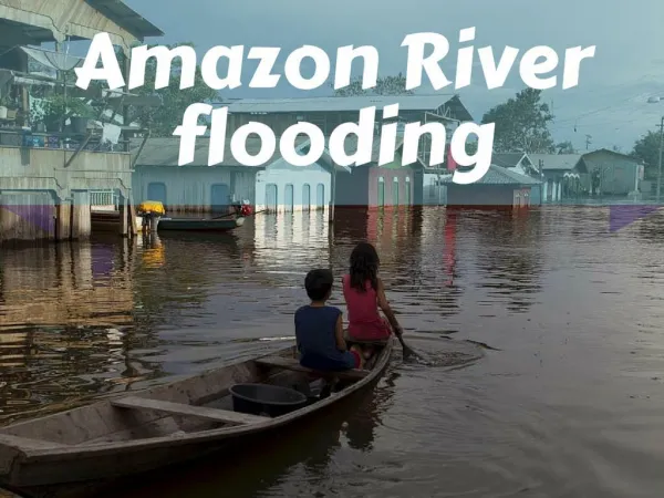
Environmental Problems • Deforestation causes erosion and soil loss, sedimentation in the rivers, unbalance in the vital ecosystem. • The expansion of urbanization; destruction of the fragile ecosystems. • Two largest cities in river basin: Manaus and Belen (over 1.5 million). • Iquitos (Peru), Leticia(Colombia), Lago Agrio(Ecuador) • Water pollution and quality degradation • Use of the agriculture pesticides, inadequate wastewater treament from populated area • Inadequate water use, and • Change of the hydrologi cycle related with climate change.
Deforestation Main Causes: • Cattle racnches • Agriculture. Small scale 230,000 square km during the past 13 years. Now 7,700 square km per year. 1,000 tons/km2/year of sediment flowing to the Atlantic Ocean 600-800 tons per year. 65 % Silimoes 35 % Madeira
Main Causes: • Cattle racnches • Agriculture. Small scale 230,000 square km during the past 13 years. Now 7,700 square km per year. Insert Figures about the deforestation
Deforestation by country Main Causes: • Cattle racnches • Agriculture. Small scale 230,000 square km during the past 13 years. Now 7,700 square km per year. Insert Figures about the deforestation
Water Pollution Problems wastewater treatment in cities such as Iquitos (Peru), Manaus and Belen in Brazil, Leticia in Colombia. Over 0.5 million of gold miners are located through the Amazon River Basin 100 Tons of mercury are estimated to be dumped in the Amazon Basin. Gold-mining has caused mercury contamination of the rivers which poses a serious health threat to local human and animal populations Studies carried out in Tapajos River basin shown high levels of mercury in fishermen 14 -20 PPM on the Average
Treaty 1978 Treaty of cooperation among the countries of the Amazon basin Brazil, Peru, Bolivia, Colombia, Ecuador, Guyana, Surinam, and Venezuela. 07/03/1978 The Contracting countries agree to carry out joint actions and efforts to promote the harmonious development of their respective Amazonian territories in such a way that these joint actions produce equitable and mutually beneficial results; as such as the environment preservation and the conservation and rational utilization of the natural resources . This treaty was re launched in 1998.
Navigation Treaties Port Manaus Ocean ships can navigate more less 1600 km Iquitos In Peru. Riverboats. Transport of different products. Treaty of commerce and river navigation between Brazil and Colombia August 21, 1908. Treaty of commerce and river navigation between Brazil and Bolivia August 12, 1910 Treaty of delimitation, commerce and navigation between Brazil y Peru. Treaty 1918 ratified in 1927.
Projects • Project GEF Amazon. OTCA/GEF/PNUMA/OEA. Integrated and sustainable management of transboundary water resources in the Amazon River basin. United Nations Environment Programme (UNEP). Oct 2005. • The main objective of this project is strengthen the institutional framework for planning and carry out activities for the protection and integrated management of the land and water resources in a coordinated and coherent manner in the Amazon River basin, considering the climatic change experienced in the basin.
Projects Some World Bank projects: Integrated management of aquatic resources in the Amazon region project (AQUABIO) The objective is to support to the multi-stakeholder, integrated management approach to the conservation and sustainable use o f freshwater biodiversity in public policies and programs in the Brazilian Amazon River Basin (2005) Amazon region protected areas project (ARPA) . 2002 28 million will be protected over 10 years. Pilot program to conserve the Brazilian rainforest (PPG7). 1992. Pilot Program floodplain resources management project (PROVERZEA). 2000
Fishing and floodplain Over 1700 species of freshwater More less 50 species are marked human for consumption. Tambaqui, Jaraqui, Tucunure, species of catfish: Pirapitinga and Piraruca. Area flood plain: 307,300 square Kilometers (4.5 % total area) Conflict of human groups: riberihnos. After, 1946, the Brazilian Federal government established: Floodplain as federal land.
Dams and hydropower 90 % of the electricity produced in Brazil is from hydropower. Tucurui Dam. Hydropower generation, no irrigation. 8,000 MW. The largest dams built in a tropical rainforest with 2,875 km2. It has displaced 40,000 people, destroyed the habit fish and plants. Belo Monte Dam built on Xingu River The Balbina dam on the Uatumã River in Amazonas state, and Samuel Dam on the Jamari River