Download
1 / 4
40 likes | 105 Views
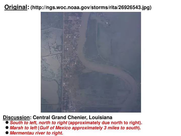
Original : (http://ngs.woc.noaa.gov/storms/rita/26926543.jpg). Discussion : Central Grand Chenier, Louisiana South to left, north to right (approximately due north to right). Marsh to left ( Gulf of Mexico approximately 3 miles to south ). Mermentau river to right.

E N D
Original: (http://ngs.woc.noaa.gov/storms/rita/26926543.jpg) Discussion: Central Grand Chenier, Louisiana • South to left, north to right (approximately due north to right). • Marsh to left (Gulf of Mexico approximately 3 miles to south). • Mermentau river to right.
Annotated: (http://ngs.woc.noaa.gov/storms/rita/26926543.jpg) Sandra Jones’ home Jones Street Discussion: Sandra Jones' home (original view) • Some flooding evident. • Trees appear intact. • No damage in this view.
Annotated: (http://terraserver.microsoft.com/image.aspx?PgSrh:NavLon=-92.975&PgSrh:NavLat=29.76667) Sandra Jones’ home Jones Street Discussion: Sandra Jones' home • Note "dry" details.
Annotated: Zoom View Jim Bonsall Lane State Park State Park Wharf Unknown (trees?) La SH 82 Methodist Church Old Jones' home Original position of old Jones' home McCall Road "Aunt Frankie's" Home (Elevated) Swimming pool Jones' Wharf Sandra Jones' home Jones Street Jones' Barn Discussion: Sandra Jones' home (zoom view) • Some deep flooding probable. • Barn/road higher, obviously debris near barn indicates flooding.