Download
1 / 14
160 likes | 379 Views
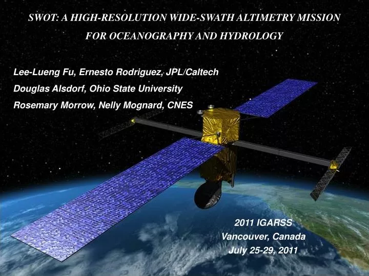
SWOT: A HIGH-RESOLUTION WIDE-SWATH ALTIMETRY MISSION FOR OCEANOGRAPHY AND HYDROLOGY. Lee-Lueng Fu, Ernesto Rodriguez, JPL/Caltech Douglas Alsdorf, Ohio State University Rosemary Morrow, Nelly Mognard, CNES. 2011 IGARSS Vancouver, Canada July 25-29, 2011. A Mission in Development.

E N D
SWOT: A HIGH-RESOLUTION WIDE-SWATH ALTIMETRY MISSION FOR OCEANOGRAPHY AND HYDROLOGY Lee-Lueng Fu, Ernesto Rodriguez, JPL/Caltech Douglas Alsdorf, Ohio State University Rosemary Morrow, Nelly Mognard, CNES 2011 IGARSS Vancouver, Canada July 25-29, 2011
A Mission in Development • SWOT (Surface Water and Ocean Topography) is a satellite mission being jointly developed by NASA and CNES with contributions from CSA. Expected launch date is in 2019. • Science Goals – (1) study hydrological processes by determining the storage and discharge rate of water on land. (2) study the oceanic mesoscale and submesoscale processes that determine the kinetic energy of ocean circulation and its transport of water properties. • Societal Benefits – Address two key issues facing a warming planet: (1) the variability of fresh water resources. (2) the capacity of ocean circulation in regulating the rate of warming. • Technology Goals – Set the standard for future operational altimetry missions.
Water Storage in Lakes • Arctic lakes are • disappearing as • permafrost melts • SWOT will measure water storage change (ΔS ) to better than 10% for lakes 250m by 250m in size. • SWOT will measure ΔS in ~30 million lakes, globally; accounting for as much as 80% of the world’s changing surface water volume.
River Flow and Discharge Rates Expected SWOT Sampling in North America • Floods are poorly measured whereas flow information from rivers crossing international boundaries is rarely shared. • SWOT will measure river hydraulic parameters for estimating river discharge. • SWOT will measure flood waves and estimate discharge along entire networks of rivers, globally. Coverage by OSTM/Jason-2
Space time sampling of radar altimetry missions 10 100 days 1000 km 100 km WSOA 10 km 1 km SWOT
Mapping Global Ocean Eddy Variability Cheney et al 1983 TOPEX/Poseidon & ERS Data Ducet et al 2000 cm
Ocean Currents and Eddies Have Small Scales Conventional altimeters resolve only the large mesoscale eddies (Jason-2/Envisat) High-resolution ocean models suggest a ubiquitous presence of submesocale eddies ECCO2 50% of the vertical exchange of heat and dissolved CO2 takes place at the submesoscales. Deepwater Horizon oil spill
High resolution achieved via Synthetic Aperture Radar Off-nadir height measurement achieved via radar interferometry High-resolution along flight via Doppler shift in frequency h= H –r1 cos(Ө ) δh = r1δθsin(θ) = [r1 tan(θ) λ /2π B] δφ
Radar Interferometry was successfully demonstrated by JPL’s Shuttle Radar Topography Mission (SRTM) 60m X/C band (3-6 cm wavelengths)
The SWOT Mission Configuration Ka band (0.85 cm wavelength) Nadir interferometry signals enhanced by a nadir receiver
SSH wavenumber spectrum 1000 100 25 10 km Assemblage of ocean spectra k-4 k-2 Jason noise floor SWOT noise spectrum SWOT resolution
SWOT Sampling characteristics (78 deg inclination, 22 day repeat orbit)
Additional Applications Ocean Bathymetry Sea Ice Freeboard Ice Sheet Topography
Summary • SWOT will provide a revolutionary set of measurements of the elevation of land surface water and ocean topography globally. • The high-resolution swath measurements will resolve lakes of 250m x 250m area and rivers of 100 m width, and oceanic eddies of 10-km wavelength. • The unprecedented resolution and coverage of SWOT will enable breakthroughs in understanding the balance of water budget on land and energy budget of ocean circulation. • Significant improvements are expected in ocean modeling for predicting future climate and in fresh water management in response to climate change. • Other applications include ocean bathymetry, sea ice thickness, ice sheet topography, coastal processes, etc.