Download

1 / 21
230 likes | 377 Views
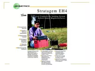
Stratagem EH4 Geometrics, Inc. Stratagem EH4 Hybrid-Source Magnetotellurics. Frequency range of 10 Hz to 90k Hz Approx. depth of investigation from 5m to 1km Portable with rapid setup and teardown Full tensor MT and CSAMT measurements

E N D
Stratagem EH4Hybrid-Source Magnetotellurics • Frequency range of 10 Hz to 90k Hz • Approx. depth of investigation from 5m to 1km • Portable with rapid setup and teardown • Full tensor MT and CSAMT measurements • In-field display and printout of 1D inversion and 2D depth section • In-field display and print out of sounding curves • In-field display and print out of signal amplitudes, phase, and coherency curves
Applications • Minerals Exploration • Groundwater Exploration • Engineering Studies • Academic and Scientific Research
Test Survey for geothermal exploration in China. Red (conductive) area is location of a know fault with geothermal activity. Note high resolution of fault dip. Depth of 250 meters.
Minerals Exploration: Resistive (blue) areas correspond to silicification zones with high concentration of hard-rock gold.
Groundwater Exploration: Resistive (darker) areas correspond to paleochannel acting as a confining aquifer in high clay content sediments. A well drilled over the resistive body was highly productive.
Ground water exploration in China: The two red lines indicate suspected faults/fracture zones. A well was drilled in the second (deeper) fracture and provided the most productive fresh water well in the region.
Equipment Setup • Electric fields measured with galvanic stakes (can use porous pot for low-freq. measurements below 10 Hz) • Magnetic fields measured with induction coils • Natural field measurements from 10 Hz to 90k Hz • Transmitter intended to fill in the natural field gaps in the range from 1k Hz to 70 k Hz.
Four channel operation (two electric and two magnetic) allows for rapid deployment and data collection.
Induction-Loop Antenna for high-frequency, controlled-source operation. Dual-loops allow full tensor CSAMT measurements.
In-Field Display and Printout • Sounding curves of full tensor measurements • Signal amplitude • Phase • Coherence and error bars • 1D Bostick transform • 2D depth sections (EMAP) • X and Y location map of all measurement stations.
Automatic calculation and display of signal spectral amplitudes of magnetic and electric fields
Real-time In-Field Display of Sounding Curves for app. res. Vs. freq. and Bostick resistivity vs. depth
In-Field 2D Depth Sections (built-in field printer in black and white)
Stratagem EH4 from Geometrics • High-resolution natural-field and controlled-source data • Reliable, proven technology • Fastest, most cost effective way for exploration to depths of greater than 100 meters and less then 1,000 meters • Backed by Geometrics 30 years of experience in geophysical instruments
Stratagem Theory of Operation • Stratagem EH4 is a magnetotellurics instrument used to measure ground resistivity. Frequency domain EM instrument. • Ground resistivity can be calculated from the ratio of the amplitudes of the magnetic and electrics fields generated by currents in the ground (telluric currents). Resistivity in Ohm-meters is ρ = (0.2/f)*(E/H)2 where ρ is apparent resistivity, E is amplitude of the electric field, and H is amplitude of the orthogonal magnetic field. • Currents generated by natural fields (lightning strikes) and artificial source (transmitter antenna). • Electrode stakes used to measure electric fields and highly sensitive magnetic coils used to measure magnetic fields.
Stratagem Theory 2 • Time series from electric and magnetic fields are converted to frequency domain measurements by Fourier transformation. • Calculating apparent resistivities at multiple frequencies provides sounding curve of apparent resistivity vs frequency. • Inverting frequency sounding curves gives true resistivity and depth. • 2-D depth sections derived from inversion data and filtering.