Download
1 / 1
10 likes | 117 Views
Water Monitoring Site Location in Greene County, PA & Cattaraugus County, NY. Methods. Introduction.

E N D
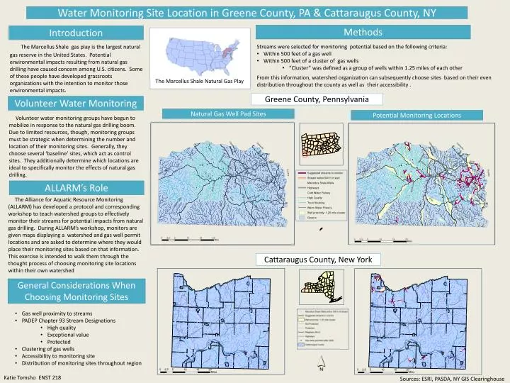
Water Monitoring Site Location in Greene County, PA & Cattaraugus County, NY Methods Introduction The Marcellus Shale gas play is the largest natural gas reserve in the United States. Potential environmental impacts resulting from natural gas drilling have caused concern among U.S. citizens. Some of these people have developed grassroots organizations with the intention to monitor those environmental impacts. • Streams were selected for monitoring potential based on the following criteria: • Within 500 feet of a gas well • Within 500 feet of a cluster of gas wells • “Cluster” was defined as a group of wells within 1.25 miles of each other From this information, watershed organization can subsequently choose sites based on their even distribution throughout the county as well as their accessibility . The Marcellus Shale Natural Gas Play Greene County, Pennsylvania Volunteer Water Monitoring Natural Gas Well Pad Sites Potential Monitoring Locations Volunteer water monitoring groups have begun to mobilize in response to the natural gas drilling boom. Due to limited resources, though, monitoring groups must be strategic when determining the number and location of their monitoring sites. Generally, they choose several ‘baseline’ sites, which act as control sites. They additionally determine which locations are ideal to specifically monitor the effects of natural gas drilling. ALLARM’s Role The Alliance for Aquatic Resource Monitoring (ALLARM) has developed a protocol and corresponding workshop to teach watershed groups to effectively monitor their streams for potential impacts from natural gas drilling. During ALLARM’s workshop, monitors are given maps displaying a watershed and gas well permit locations and are asked to determine where they would place their monitoring sites based on that information. This exercise is intended to walk them through the thought process of choosing monitoring site locations within their own watershed Cattaraugus County, New York General Considerations When Choosing Monitoring Sites • Gas well proximity to streams • PADEP Chapter 93 Stream Designations • High quality • Exceptional value • Protected • Clustering of gas wells • Accessibility to monitoring site • Distribution of monitoring sites throughout region Katie Tomsho ENST 218 Sources: ESRI, PASDA, NY GIS Clearinghouse