Download
1 / 20
220 likes | 369 Views
Water Utility GIS. Christopher Kahn Project Manager, GIS April 15 th , 2010. Company Property Assets: Leverage GIS to Provide Access & Analysis. Prior to 2010. A GIS property map request is generated…. and the data hunt begins…. 2. 2. Hypothetical GIS Property Request Workflow….

E N D
Water Utility GIS Christopher Kahn Project Manager, GIS April 15th, 2010 Company Property Assets: Leverage GIS to Provide Access & Analysis
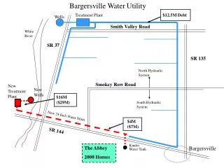
Prior to 2010 A GIS property map request is generated… and the data hunt begins… 2 2
Hypothetical GIS Property Request Workflow… • Determine data requirments • Locate record in various databases • Compare / conflate various records • Open map document • Open attribute selection tool • Zoom to block / lot • Change all surround elements • Change overview map • Query on watershed, various overlay layers • Edit title block w/ specific information • What if parcel data is bad? • Edge-match • What if it doesn't match our records? • More Research • What if block / lot geometry unavailable? • Find electronic tax map, download image • Locate property in GIS • Geo-reference • Digitize • What if tax maps missing? • Contact legal department for deed • Digitize from Metes & Bounds in deed • Export finished product. • What if someone requested 80 such maps?? “The Old Way”
Business Reality Over 500 properties across state Existing databases vary in completeness & formatting: Tax, Legal, Environmental Compliance, Asset Planning, etc Satisfy the individual needs of departments Not comprehensive; No uniform mapping component Insufficient forRegulatory orManagement: Map requests Comprehensive data requests Requests that require spatial overlay Spatial or attribute query requests GIS analysis requests No “Self-Help” … all property map requests require research. Bulk Requests can take weeks to compile 4
Business Need • Seamless property database in GIS • Simple schema with logical key field (PAMS) • Dynamic Template to respond quickly to GIS requests • Automate common overlay requests • Automate map production • Web Access for “Non-GIS” users • Easy search & query, identify, print tools • Environmental Chart tools • Industry friendly base map 5
Objective The objective of this project is to create efficient ways to access, analyze, & edit New Jersey American Water property information along with related, contextual GIS layers. Goals: The primary goal is to design and build an up to date, seamless GIS property layer for New Jersey American Water. The secondary goal is to provide efficient ways to access, analyze, query, edit, and print property information for end users with and without GIS knowledge. The tertiary goal is to design a base map that uses cartographic design principles to support users in a variety of web-based geospatial water utility tasks.
Methodology • Identification of business need • Determine objective • Requirements / Data gathering • Schema design • Related table design • Database population • Dynamic map templates • Web map design
Parcels (NJ State Layer) Parcels (NJAW) Code Name Code Name Code Name Code Name Parcels Abstract Class Schema Design + PAMS_PIN :esriFieldTypeString (38) +MUN :esriFieldTypeString (4) + BLOCK :esriFieldTypeString (10) + LOT :esriFieldTypeString (10) + QCODE :esriFieldTypeString (11) Domain : CoCode Domain : Town + NAME :esriFieldTypeString (100) + MUN :Town+ COUNTY :CoCode + ADDRESS : esriFieldTypeString (50) + ACRES_LEGAL :esriFieldTypeDouble + ACRES_GIS :esriFieldTypeDouble + STATUS :PropStatus = Own + VACANT :Yes / No = No + USE_LEASE :Yes / No =No + DATE_PURCHASED :esriFieldTypeDate + DATE_SOLD : esriFieldTypeDate + DEED : esriFieldTypeString (100)*Link* + ZONING : esriFieldTypeString (30) 01 Atlantic 02 Bergen etc , etc 0101 Absecon 0302 Beverly etc , etc + LASTUPDATE :esriFieldTypeDate Domain : PropStatus Domain : Yes/No Sold Sold Own Own Let Lease Oth Other Y Yes N No
Related Tables Parcels (NJAW) Environmental Table Tax Table + PAMS_PIN : esriFieldTypeString (38) + R_P : esriFieldType String (10) + LEASE: esriFieldTypeString (20) + AWC_DESC. : esriFieldTypeString (50) + TAX_DESC : esriFieldTypeString (50) + PAYEE : esriFieldTypeString (50) + VENDOR_ID : esriFieldTypeString (20) + PHONE : esriFieldTypeString (15) + GL_ACCT_N : esriFieldTypeString (15) + TAX_BILL_N : esriFieldTypeString (15) + LAND_06 : esriFieldTypeDouble + BLDG_06 : esriFieldTypeDouble + TOTAL_06 : esriFieldTypeDouble + LAND_07 : esriFieldTypeDouble + BLDG_07 : esriFieldTypeDouble + TOTAL_07 : esriFieldTypeDouble + LAND_08 : esriFieldTypeDouble + BLDG_08 : esriFieldTypeDouble + TOTAL_08 : esriFieldTypeDouble + LAND_09 : esriFieldTypeDouble + BLDG_09 : esriFieldTypeDouble + TOTAL_09 : esriFieldTypeDouble + LAND_10 : esriFieldTypeDouble + BLDG_10 : esriFieldTypeDouble + TOTAL_10 : esriFieldTypeDouble + PAID_06 : esriFieldTypeDouble + PAID_07 : esriFieldTypeDouble + PAID_08 : esriFieldTypeDouble + PAID_09 : esriFieldTypeDouble + PAID_10 : esriFieldTypeDouble + TAX_RATE : esriFieldTypeDouble + F_DUE : esriFieldTypeString (4) + S_DUE : esriFieldTypeString (4) + T_DUE : esriFieldTypeString (4) + F_DUE : esriFieldTypeString (4) + PAMS_PIN : esriFieldTypeString (38) + Con_Buffer : Yes / No + Critical : Yes / No + E_Senstv : Yes / No + Historic : Yes / No + Hist_Name : esriFieldTypeString (50) + S_Park : Yes / No + SP_Name : esriFieldTypeString (50) + L_Park : Yes / No + LP_Name : esriFieldTypeString (50) + Riv_Bisect : Yes / No + Riv_Name : esriFieldTypeString (50) + Prct_SMRT : esriFieldTypeShort + WH_Travel : esriFieldTypeString (20) + NAME :esriFieldTypeString (100) + PAMS_PIN :esriFieldTypeString (38) + BLOCK :esriFieldTypeString (10) + LOT :esriFieldTypeString (10) + QCODE :esriFieldTypeString (11) + MUN :Town+ COUNTY :CountyCode + ADDRESS : esriFieldTypeString (50) + ACRES_LEGAL :esriFieldTypeDouble + ACRES_GIS :esriFieldTypeDouble + STATUS :PropStatus = Own + VACANT :Yes / No = No + USE_LEASE :Yes / No =No + DATE_PURCHASED :esriFieldTypeDate + DATE_SOLD : esriFieldTypeDate + DEED : esriFieldTypeString (100)*Link* + ZONING : esriFieldTypeString (30) Environmental “Near” Table + PAMS_PIN : esriFieldTypeString (38) + SP_Name : esriFieldTypeString (50) + SP_Dist : esriFieldTypeShort + SP_Bearing : esriFieldTypeString (10) + LP_Name : esriFieldTypeString (50) + LP_Dist : esriFieldTypeShort + LP_Bearing : esriFieldTypeString (10) + HS_Name : esriFieldTypeString (50) + HS_Dist : esriFieldTypeShort + HS_Bearing : esriFieldTypeString (10) + Riv_Name : esriFieldTypeString (50) + Riv_Dist : esriFieldTypeShort + Riv_Bearing : esriFieldTypeString (10) (Many – to – One) Land Use Table (2002) + PAMS_PIN : esriFieldTypeString (38) +Type2002 :esriFieldTypeString (20) +Percent :esriFieldTypeShort 9
Content Database Population • Start with tax record • Compare to other databases • ** Normalize / conflate data ** • Locate property in existing parcel layers • Copy into geometry into property layer • If no existing parcel GIS available… • Log into E-Taxmaps.com • Save tax map as .tiff format • Geo-reference • Digitize outline in NJAW layer • Repeat (~500 times)
Edge-Matched Poor Edge-matching
Raw Data 15
Project Results • Seamless GIS Property Layer • Specialty Overlay Tables • ‘Dynamic’ Property Map Template • Automates common overlay inqueries • Automates map production • New Web Base-Map • Web Query, Export, Edit Print & Charting Tools The objective of this project is to create efficient ways to access, analyze, & edit New Jersey American Water property information along with related, contextual GIS layers.
References Questions • Best Practices for Creating an ArcGIS Server Web Application for Municipal / Local Government. http://www.esri.com/library/whitepapers/pdfs/creating-arcgisserver-web-mapping.pdf Accessed November 2009. • ESRI Tax Parcel Template Poster. http://resources.esri.com/landrecords/index.cfm?fa=codeGalleryDetails&scriptID=16559. Accessed December 2009 • Fowler, Martin. (2004). UML Distilled. Boston: Addison-Wesley. • Kruchten, Philippe. (2004). The Rational Unified Process An Introduction. Boston: Addison-Wesley. • Meyer, N. V. (2004). GIS and Land Records The ArcGIS Parcel Data Model. Redlands, CA: ESRI Press. • Meeham, Bill (2007). Empowering Electric & Gas Utilities with GIS. Redlands, CA: ESRI Press. • New Jersey Geographic Network. https://njgin.state.nj.us/NJ_NJGINExplorer/IW.jsp. Accessed December, 2009. • NJAW Water Network Data Model. NJAW_Water_Physical.pdf Revised 9.20.07. Internal Document. New Jersey American Water • Rayburn, S. R. (2004). The Use of GIS in Water Utility Asset Management, Four Seasons Subdivision of Lufkin, Texas. Thesis (M.I.S.)--Stephen F. Austin State University, August, 2004.