Download
1 / 18
190 likes | 349 Views
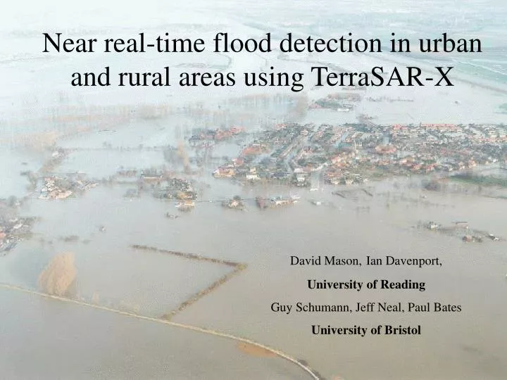
Near real-time flood detection in urban and rural areas using TerraSAR-X. David Mason, Ian Davenport, University of Reading Guy Schumann, Jeff Neal, Paul Bates University of Bristol. Need for real-time visualisation tools.

E N D
Near real-time flood detection in urban and rural areas using TerraSAR-X David Mason,Ian Davenport, University of Reading Guy Schumann, Jeff Neal, Paul Bates University of Bristol
Need for real-time visualisation tools • Pitt Commission set up by UK government recommended real-time visualisation tools be available for emergency reponders • Vast majority of flooded area may be rural, but important to detect urban flooding due to increased risks/costs • ASAR/ERS-2 have too low a resolution to detect urban floods – but high resolution SARs can.
Fusion of algorithms • Near real-time algorithm for rural flood detection developed at DLR • Non-real-time algorithm for urban flood detection developed at Reading • Objective is to fuse and automate to develop near real-time algorithm for flood detection in urban and rural areas • Algorithm assumes LiDAR available for urban area
N B B A A 2km TerraSAR-X image of the Severn flood of July 2007
TerraSAR-X image of Tewkesbury flooding on 25th July 2007 showing urban areas (3m resolution, dark areas are water).
TerraSAR-X θ M O R h2 h1 A Y C N B D Layover (AB) and shadow (CD) in a flooded street between adjacent buildings.
Regions unseen by TerraSAR-X in LiDAR DSM due to combined shadow and layover (satellite looking West).
Detection of rural flooding • Detect flood extent in rural areas, then in urban area guided by rural flood extent • Rural flood detection achieved by segmenting SAR image into homogeneous regions (objects), then classifying them • Use eCognition Developer software for multi-resolution segmentation and classification.
Flood detection in urban areas • Seed pixels identified with backscatter less than threshold, and heights less than or similar to adjacent rural flood • Seed pixels clustered together if sufficiently close • Shadow/layover masked out
Correspondence between the TerraSAR-X and aerial photo flood extents in main urban areas of Tewkesbury, superimposed on the LiDAR image (yellow = wet in SAR and aerial photos, red = wet in SAR only, green = wet in aerial photos only). Flood detection accuracy = 75%.
Correspondence between the TerraSAR-X and aerial photo flood extents over the rural validation area (region B), superimposed on the TerraSAR-X image (blue = wet in SAR and aerial photos, red = wet in SAR only, green = wet in aerial photos only). Flood detection accuracy = 89%.
(b) (a) Possible multi-scale visualisation of flood extents in (a) rural (blue = predicted flood), and (b) urban areas (yellow = predicted flood).
Operational considerations • Ensure that – • can task a satellite in time to acquire image of developing flood • short time delay between image acquisition and production of SAR flood extent • Preprocessing operations can be carried out in parallel with tasking satellite e.g. generation of shadow-layover map • Blueprint for operational system is ESA FAIRE system – produces multi-look geo-registered ASAR images 3 hours after acquisition
Conclusion • Automatic near real-time algorithm developed that can detect rural flooding with good accuracy, urban flooding with less good accuracy • Need to test on more flood events • Need to improve urban classification accuracy