Download
1 / 1
10 likes | 62 Views
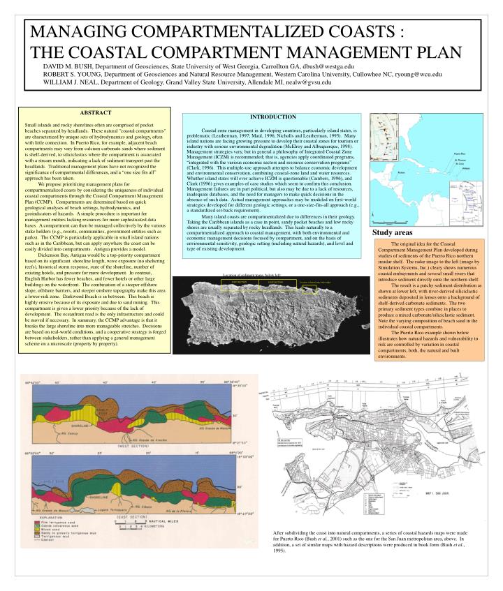
Study areas. Location of sediment maps, below left:. WEST SECTION. EAST SECTION. Location of hazard map, below right:.

E N D
Study areas Location of sediment maps, below left: WEST SECTION EAST SECTION Location of hazard map, below right: After subdividing the coast into natural compartments, a series of coastal hazards maps were made for Puerto Rico (Bush et al., 2001) such as the one for the San Juan metropolitan area, above. In addition, a set of similar maps with hazard descriptions were produced in book form (Bush et al., 1995). MANAGING COMPARTMENTALIZED COASTS : THE COASTAL COMPARTMENT MANAGEMENT PLAN DAVID M. BUSH, Department of Geosciences, State University of West Georgia, Carrollton GA, dbush@westga.edu ROBERT S. YOUNG, Department of Geosciences and Natural Resource Management, Western Carolina University, Cullowhee NC, ryoung@wcu.edu WILLIAM J. NEAL, Department of Geology, Grand Valley State University, Allendale MI, nealw@gvsu.edu ABSTRACT Small islands and rocky shorelines often are comprised of pocket beaches separated by headlands. These natural "coastal compartments" are characterized by unique sets of hydrodynamics and geology, often with little connection. In Puerto Rico, for example, adjacent beach compartments may vary from calcium carbonate sands where sediment is shelf-derived, to siliciclastics where the compartment is associated with a stream mouth, indicating a lack of sediment transport past the headlands. Traditional management plans have not recognized the significance of compartmental differences, and a “one size fits all” approach has been taken. We propose prioritizing management plans for compartmentalized coasts by considering the uniqueness of individual coastal compartments through the Coastal Compartment Management Plan (CCMP). Compartments are determined based on quick geological analyses of beach settings, hydrodynamics, and geoindicators of hazards. A simple procedure is important for management entities lacking resources for more sophisticated data bases. A compartment can then be managed collectively by the various stake holders (e.g., resorts, communities, government entities such as parks). The CCMP is particularly applicable in small island nations such as in the Caribbean, but can apply anywhere the coast can be easily divided into compartments. Antigua provides a model. Dickenson Bay, Antigua would be a top-priority compartment based on its significant shoreline length, wave exposure (no sheltering reefs), historical storm response, state of the shoreline, number of existing hotels, and pressure for more development. In contrast, English Harbor has fewer beaches, and fewer hotels or other large buildings on the waterfront. The combination of a steeper offshore slope, offshore barriers, and steeper onshore topography make this area a lower-risk zone. Darkwood Beach is in between. This beach is highly erosive because of its exposure and due to sand mining. This compartment is given a lower priority because of the lack of development. The oceanfront road is the only infrastructure and could be moved if necessary. In summary, the CCMP advantage is that it breaks the large shoreline into more manageable stretches. Decisions are based on real-world conditions, and a cooperative strategy is forged between stakeholders, rather than applying a general management scheme on a microscale (property by property). INTRODUCTION Coastal zone management in developing countries, particularly island states, is problematic (Leatherman, 1997; Maul, 1996; Nicholls and Leatherman, 1995). Many island nations are facing growing pressure to develop their coastal zones for tourism or industry with serious environmental degradation (McElroy and Albuquerque, 1998). Management strategies vary, but in general a philosophy of Integrated Coastal Zone Management (ICZM) is recommended; that is, agencies apply coordinated programs, “integrated with the various economic sectors and resource conservation programs” (Clark, 1996). This multiple-use approach attempts to balance economic development and environmental conservation, combining coastal-zone land and water resources. Whether island states will ever achieve ICZM is questionable (Cambers, 1996), and Clark (1996) gives examples of case studies which seem to confirm this conclusion. Management failures are in part political, but also may be due to a lack of resources, inadequate databases, and the need for managers to make quick decisions in the absence of such data. Actual management approaches may be modeled on first-world strategies developed for different geologic settings, or a one-size-fits-all approach (e.g., a standardized set-back requirement). Many island coasts are compartmentalized due to differences in their geology. Taking the Caribbean islands as a case in point, sandy pocket beaches and low rocky shores are usually separated by rocky headlands. This leads naturally to a compartmentalized approach to coastal management, with both environmental and economic management decisions focused by compartment, and on the basis of environmental sensitivity, geologic setting (including natural hazards), and level and type of existing development. The original idea for the Coastal Compartment Management Plan developed during studies of sediments of the Puerto Rico northern insular shelf. The radar image to the left (image by Simulation Systems, Inc.) cleary shows numerous coastal embayments and several small rivers that introduce sediment directly onto the northern shelf. The result is a patchy sediment distribution as shown at lower left, with river-derived siliciclastic sediments deposited in lenses onto a background of shelf-derived carbonate sediments. The two primary sediment types combine in places to produce a mixed carbonate/siliciclastic sediment. Note the varying composition of beach sand in the individual coastal compartments. The Puerto Rico example shown below illustrates how natural hazards and vulnerability to risk are controlled by variation in coastal compartments, both, the natural and built environments.