Download
1 / 28
280 likes | 427 Views
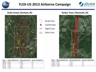
Airborne Laser/GPS Topo Mapping applied to ICESat Cal/Val. … and hopefully to Cryosat!. NASA/NSF ATM MAPPING OF THE DRY VALLEYS, ANTARCTICA. DEC, 2001. ICESat Groundtracks. NSF/ICESat Site Selection. NASA/NSF ATM MAPPING OF DRY VALLEYS, ANTARCTICA DEC. 2001. Flight Coverage.

E N D
Airborne Laser/GPS Topo Mapping applied to ICESat Cal/Val … and hopefully to Cryosat!
NASA/NSF ATM MAPPING OF THE DRY VALLEYS, ANTARCTICA DEC, 2001
NASA/NSF ATM MAPPING OF DRY VALLEYS, ANTARCTICA DEC. 2001 • Flight Coverage • Topography Beacon Valley
ATM and GLAS maps ATM GLAS 20km scale
ATM and GLAS maps (detail of elevation)(GLAS footprint size is not to scale) 200-m scale ATM GLAS
GLAS - ATM comparison of elevation(GLAS processing Release 18)
Combinations of Data Between 2003 and 1997