Download
1 / 19
190 likes | 364 Views
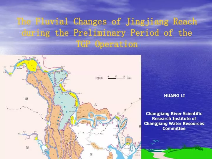
The Fluvial Changes of Jingjiang Reach during the Preliminary Period of the TGP Operation. HUANG LI. Changjiang River Scientific Research Institute of Changjiang Water Resources Committee. content. 1 Introduction. 2 calculation analysis. 3 field data analysis. 1 Introduction.

E N D
The Fluvial Changes of Jingjiang Reach during the Preliminary Period of the TGP Operation HUANG LI Changjiang River Scientific Research Institute of Changjiang Water Resources Committee
content • 1 Introduction • 2 calculation analysis • 3field data analysis
1 Introduction • Jingjiang is the major reach in the middle and lower reach of Changjiang river.Jingjiang reach is 347.2km. • The upper Jingjiang is presently about 171.7km long from Zhicheng to Ouchi-mouth,and is a slightly curved fork river type. • The lower Jingjiang is about 175.5km long from Ouchi-mouth to Chenglingji, and is typical of sinuous stream.
Upper-Jingjiang reach Lower-Jingjiang reach Middle reach of Changjiang river,955km long
2 calculation analysis • Main conclusions (1) • at the end of the twentieth year,the river reach from Yichang to Chenglingji will be scoured,the quantity will be 17.97×10⁸ t and about 13.31×10⁸ m3. • The scouring intensity increased gradually along the river reach. • The erosion above Taiping-mouth will reach an equilibrium approximately.
Table1 Accumulated deposition-erosion amounts from Yichang to Chengliji
Table2 Accumulated deposition-erosion areas from Yichang to Chengliji unit:m2
Deposition-erosion amounts (104 m3) Yichang-Songzikou Songzikou-Taipingkou Fig1 1-10 year deposition-erosion process from Yichang to Chenglingji Taipingkou-Ouchikou Ouchikou-Chenglingji The years after the TGP operation
Deposition-erosion amounts (104 m3) Taipingkou-Ouchikou Ouchikou-Chenglingji The years after the TGP operation Fig2 11-20 year deposition-erosion process from Taipingkou to Chenglingji
Main conclusions (2) • At the end of year 2009,the main river channel of the upper Jingjiang reach will be scoured 3.71×10⁸ ton when the discharge in Yichang is 5500m3/s,and the lower Jingjiang reach, 2.16 ×10⁸ ton. • At the end of year 2022,the upper Jingjiang reach, 4.88 ×10⁸ t,the lower Jingjiang reach, 8.05 ×10⁸ t.
Elevation (wu song,m) Distance from the dam (km) Fig3 Changes of the thalweg from Yichang to Chenglingji after the operation of the TGP
Elevation (wu song,m) Distance from the dam (km) Fig4 Changes of the thalweg from Yichang to Chenglingji after the operation of the TGP
Main conclusions (3) • Because of the scouring from Yichang to Chenglingji,the relation between water level and the discharge will change correspondingly.For the mid and lower river discharge the water level will descend to some extent.
Table3 The decrease of water level after the operation of the TGP (compared to 2003) (m) Yichang Shishou Shashi Jianli
3field data analysis • Field data analysis from hydrological bureau of Changjiang Water Resources Committee show that,after TGP is put into operation in June 2003,the downstream of the TGP dam from Yichang to Chenglingji have occurred a long-distance erosion.
Table4 the amounts of erosion from Yichang to Chenglingji Note : Erosion capacity ( unite : 108 m3);Erosion intensity (unite : m3/m )