Download
1 / 32
320 likes | 408 Views
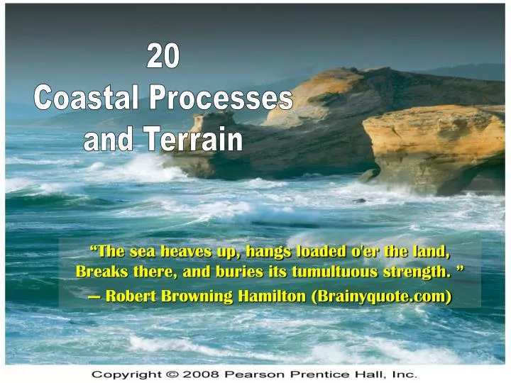
20 Coastal Processes and Terrain. “The sea heaves up, hangs loaded o'er the land, Breaks there, and buries its tumultuous strength. ” — Robert Browning Hamilton (Brainyquote.com). The Impact of Waves and Currents on the Landscape Coastal Processes Coastal Landforms.

E N D
20 Coastal Processes and Terrain “The sea heaves up, hangs loaded o'er the land, Breaks there, and buries its tumultuous strength.” — Robert Browning Hamilton (Brainyquote.com)
The Impact of Waves and Currents on the Landscape Coastal Processes Coastal Landforms Coastal Processes and Terrain
Coastal Processes Erosion – by waves, mainly Deposition – by currents, mainly Rocky cliffs and headlands Main erosional features Beaches and sandbars Main depositional features The Impact of Waves and Currents on the Landscape
Erosion and Deposition Involves the transfer of energy from the atmosphere (wind) to the hydrosphere (ocean) and then to the lithosphere (land). Wind Deposition Coast Kinetic energy transfer Wind Erosion Coastal Processes
Animation Definition – A disturbance in water caused by energy passing through it. Wave terms: wavelength, wave crest and trough, swash Fig. 20-2 Waves • Wave Motion and Wave Refraction • Tsunami
Wave Refraction (see previous animation) Fig. 20-5
Fig. 20-6. Headland erosion in Australia along the southern coast of the state of Victoria, read caption, pg 592. Formation of Arches
Wave Erosion, see caption, pg 593 • Hydraulic pounding and sea cliff erosion • Chemical action (some rocks are soluble in sea water) • Fig. 20-7 Formation of a Wave-Cut Notch
Wave Erosion Fig. 20-7 Formation of a Wave-Cut Notch Cliff face Former shore Sea Level Notch Wave-cut platform
Tides Animation (Tides) Significant erosion agents in narrow bays, margins of shallow seas, and straits. Fig. 20-9. Bay of Fundy has the highest tidal range in the world. Tidal action created these pedestal rocks on the edge of the bay, read caption, pg 595.
Changes in Sea Level and Lake Level Due to: Tectonic uplift or sinking of landmass Eustatic – increase or decrease in the volume of water in the oceans (Pleistocene glaciations). Also, global warming. Fig. 20-10. Northern California coast is experiencing tectonic uplift.
Currents and Coastal Sediment Transport • Longshore Currents (see next slide and stabilization animation) • Wave refraction • Beach Drifting • Particle-by-particle transport of beach material Figure 20-12
Fig. 20-13. Waves approaching the shore obliquely causes longshore currents and beach drifting.
Coastal Deposition Based on the sediment budget of a shore Deposition mainly occurs when inputs from longshore current and wave action exceeds outputs from storm wave action. E.g. large beaches and sand dunes Fig. 20-14. One of the largest coastal dune accumulations is on the Oregon coast. Fig. 20-14
Depositional Landforms Beaches Most widespread marine dispositional feature on land (mostly sand deposits) Fig. 20-15 Components of the beach environment Coastal Landforms
Spit and related features Spit: Linear strand of marine sediments attached to shore Formation usually involves longshore current transport Related features Fig. 20-16. Types of spits and the longshore current.
Idealized drawings of formation of spit and related features (3) Baymouth bar (2) Hook • Simple spit Bay Land Ocean
Photographs of spits and related features Fig. 20-17. Spit at Cape Henlopen, Delaware
Tombolo formation Ocean Land Small island / sea stack
Fig. 20-18. Tombolo and Mont Saint Michel on the northwest coast of France.
Barrier Islands (also, Fig 20-20, pg 602) Coastal islands, parallel to the mainland shore Complex origins Pleistocene sediments washed toward mainland or longshore transport and spit segmentation Lagoon formation Landward side of barrier island, protected from large waves Low energy environment, fine mud deposits (tidal flats) Fig. 20-19
Human Alteration of Coastal Sediment Budgets Beach starvation (unintentionally shrinking beaches) Dam construction on rivers reduces sediment discharge into oceans, starving nearby beaches of sand Old debris dam in Santa Ynez Mountains, near Santa Barbara, CA (Richard A. Crooker photo)
Beach nourishment (re-building beaches) Adding sand to beaches by dredging and pumping sand from off-shore A slurry of sand and water is pumped on shore and the sand is spread onto the beach of Rehoboth Beach, DE (Richard A. Crooker photos) (overlay)
Beach preservation (maintaining beaches) Build structures that modify longshore transport and wave action in order to keep sand on beaches Jetties and groins (see personal pictures) Fig. 20-22 Animation (Coastal Stabilization Structures)
Shorelines of Submergence Ria Shorelines (formed at the end of the last ice age) Hilly or mountainous areas flooded valleys become estuaries (long fingers of seawater projecting inland). Dams also create similar landforms, although these are technically not estuaries (see photos of Hoover Dam). Fig. 20-23, Chesapeake Bay. Read caption, pg 603.
Fjorded Coasts Fjord – glacial trough that is cut so deep that it is inundated by the sea (after glacial melting) Fig. 20-24
Wave-Cut Cliffs and Platforms (photo, pg 604) Marine Terraces are uplifted landforms (captions, pg 605) - Fig. 20-26 and 27. Near Fort Ross, CA • Shorelines of Emergence
Coral Coasts Coral Polyps Reef-building creatures, in warm tropical waters Fig. 20-28
Sinking Islands Three types of reefs Sea Level Sea Level Fringing Barrier Sea Level Atoll
Fig. 20-32. Part of the fringing reef on the island of Moorea, French Polynesia.
Shallow-water Platforms Australia’s Great Barrier Reef Fig. 20-30