Download
1 / 40
400 likes | 551 Views
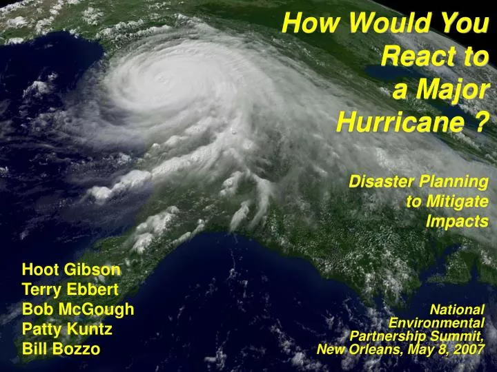
How Would You React to a Major Hurricane ? Disaster Planning to Mitigate Impacts. Hoot Gibson Terry Ebbert Bob McGough Patty Kuntz Bill Bozzo. National Environmental Partnership Summit, New Orleans, May 8, 2007. Terminology. Watch: Hurricane conditions possible within 36 hours

E N D
How Would You React to a Major Hurricane ?Disaster Planning to Mitigate Impacts Hoot Gibson Terry Ebbert Bob McGough Patty Kuntz Bill Bozzo National Environmental Partnership Summit, New Orleans, May 8, 2007
Terminology • Watch: Hurricane conditions possible within 36 hours • Warning: Hurricane force winds are expected in 24 hours or less • Hurricane Strength (Safford-Simpson Scale) • Wetlands Surge Rule: Each 2.7 miles absorbs 1 foot of surge
Katrina Builds, Nears Florida • 4 PM CDT Tuesday • Sustained Winds 35 MPH
Katrina Builds, Nears Florida • 4 AM CDT Wednesday • Sustained Winds 35 MPH
Katrina Builds, Nears Florida • 4 PM CDT Wednesday • Sustained Winds 45 MPH
Katrina Builds, Nears Florida • 4 AM CDT Thursday • Sustained Winds 50 MPH
Katrina Builds, Nears Florida • 4 PM CDT Thursday • Sustained Winds 75 MPH (Cat 1)
Katrina Leaves Florida • 4 AM CDT Friday • Sustained Winds 75 MPH (Cat 1)
Katrina Track Moves West • 4 PM CDT Friday • Sustained Winds 100 MPH (Cat 2)
Katrina Track Moves West • 10 PM CDT Friday • Sustained Winds 105 MPH (Cat 2)
Katrina Track Moves West • 4 AM CDT Saturday • Sustained Winds 115 MPH (Cat 3)
Hurricane Watch Issued • 10 AM CDT Saturday • Sustained Winds 115 MPH (Cat 3)
Hurricane Watch • 4 PM CDT Saturday • Sustained Winds 115 MPH (Cat 3)
Evacuation Considerations • 1 million people in 38 hours
Hurricane Warning Issued • 10 PM CDT Saturday • Sustained Winds 115 MPH (Cat 3)
Hurricane Warning • 4 AM CDT Sunday • Sustained Winds 145 MPH (Cat 4)
Hurricane Warning • 4 PM CDT Sunday • Sustained Winds 165 MPH (Cat 5)
Katrina’s 1st Gulf Landfall • 4 AM CDT Monday • Sustained Winds 150 MPH (Cat 4)
Katrina’s 2nd Gulf Landfall • 10 AM CDT Monday • Sustained Winds 125 MPH (Cat 3)
Katrina Downgrades • 4 PM CDT Monday • Sustained Winds 75 MPH (Cat 1)
Environmental Impact • Tidal Surge Damages Tank • Spill Contaminates 2000 Homes • Nearly 50 spillsoccur
Post Katrina – Next 2 Weeks • What are your: • Actions • Priorities • Challenges
Challenges: City of New Orleans • Transportation/Sheltering • Mission vs Compliance • Risk Management vs Risk Avoidance • Mission vs Resources (Funding) • Pets, Guns, ADA • Command and Control • Joint Field Office • Logistics/Push • Distribution of Assets
Rita Approaches • 4 PM CDT Sunday • Sustained Winds 40 MPH
Rita Approaches Gulf • 4 PM CDT Monday • Sustained Winds 70 MPH
Rita Approaches Gulf • 4 PM CDT Tuesday • Sustained Winds 100 MPH (Cat 2)
Hurricane Watch Issued • 4 PM CDT Wednesday • Sustained Winds 165 MPH (Cat 5)
Hurricane Watch • 4 AM CDT Thursday • Sustained Winds 175 MPH (Cat 5)
Hurricane Warning Issued • 4 PM CDT Thursday • Sustained Winds 145 MPH (Cat 4)
Hurricane Warning • 4 PM CDT Friday • Sustained Winds 125 MPH (Cat 3)
Rita’s Landfall • 4 AM CDT Saturday • Sustained Winds 120 MPH (Cat 3)
Rita Downgrades • 4 PM CDT Saturday • Sustained Winds 50 MPH
Goals: City of New Orleans • Create “Preference to Evacuate” • User friendly shelter plan • Better personal evacuation plans • Improve Special Assistance • Medical special needs • Elderly and hospitals • Lack of transportation • Enhance city security • Safety of city employees • Protection of equipment • Anti-looting
Conclusions • Business Continuity Implications • Environmental • Economic • Social • Planning and Practicing • Second Guessing