Download
1 / 29
290 likes | 645 Views
Justin Smith 5-14-14 2 nd period. Physical geography of the United Kingdom. Physical Geography Land.

E N D
Justin Smith 5-14-14 2nd period Physical geographyof the United Kingdom
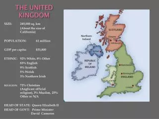
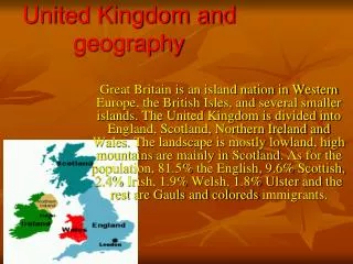
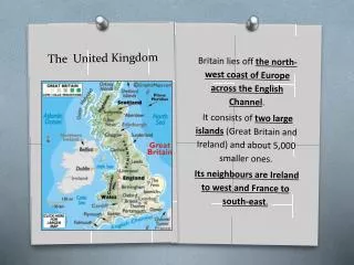
Physical Geography Land • The land divides into a highland region and a lowland region. The highlands occur north and west of a line from the Tees River, in northern England, to the Exe River, in the southwest. The lowlands lie to the south and east. • The highest and roughest sections are the Grampian Mountains and the Northwest Highlands of northern Scotland. Ben Nevis, reaching 4,406 feet (1,343 m) in the Grampians, is Britain's highest peak.
"Geograph - Photograph Every Grid Square." River Tees at Hurworth (C) Mark Harrington. N.p., n.d. Web. 14 May 2014.
Physical Geography Land • Lowland Britain is gently rolling land • Low-lying areas include the Midlands (a plain), the London basin, and the Vale (valley) of York. • Many of the coastal areas of lowland Britain are lined with cliffs, sand and pebble beaches, and reclaimed tidal land.
London Basin "The London Basin." The London Basin. N.p., n.d. Web. 14 May 2014.
"Haggs Castle Golf Club." Baysider. N.p., n.d. Web. 14 May 2014.
Physical Geography Water • The coast of Britain is often irregular and deeply indented by numerous bays, sounds, broad estuaries also known as firths. • Firths of Forth, Moray, Lorne, Clyde, and Solway, in Scotland; and The Wash, Thames estuary, Bristol Channel, and Morecambe Bay, in England.
"Durdle Door Natural Wonder on the Jurassic Coast | United Kingdom - Best of European Union." Best of European Union. N.p., n.d. Web. 14 May 2014.
Firths of Clyde "The Firth Of Clyde." Flickr. Yahoo!, n.d. Web. 14 May 2014.
"Bristol Channel." Wikipedia. Wikimedia Foundation, 05 Sept. 2014. Web. 14 May 2014.Britstol Channel
Water • Inland waters cover 1,191 square miles (3,085 km2), or somewhat more than 1 per cent of the total area. • Lakes are mainly of glacial origin and lie in the highlands
Lake District in the Cumbrian Mountains "Holiday Cottages Cumbria." Holiday Cottages in Cumbria, Self Catering Accommodation. N.p., n.d. Web. 14 May 2014.
Climate • Britain lies at the same latitude as the southern half of Canada yet has milder temperatures • During the year Winds from the south and west bring up warm air in the winter and cooler air in the summer • 38-43 degrees in the winter • 58-63 degrees in the summer • Annual precipitation can range anywhere from 18 to 200 inches
Margolis, Jonathan. "Olympic Torch Route, Day 67: Richmond, It's Authorly Nice." Theguardian.com. Guardian News and Media, 24 July 2012. Web. 14 May 2014.
"Sound and Vision Blog." Sound and Vision Blog. N.p., n.d. Web. 14 May 2014.
Carbon Footprint of the UK Citizens BBC News. BBC, n.d. Web. 14 May 2014.
Population Density of UK "England." Wikipedia. Wikimedia Foundation, 05 Nov. 2014. Web. 13 May 2014.
"Scottish Government." Economic Report on Scottish Agriculture 2013. N.p., n.d. Web. 14 May 2014.
Impacts on the people • Trade is a major source of income for the people with the abundance of ports and bays • Fishing and mining are good professions to obtain since there are an abundance of fish around the islands and plentiful minerals such as coal and iron-ore • United Kingdom has one of the largest merchant marines in the world • Approximately 80% of Britain's total land area is used for agriculture which comprises 2% of the workforce
How Geography Shapes Work Environment • Britain's manufacturing is off the charts • Most factories are located in the south and west • The new factories deal with high tech equipment such as computers and optic fibers
"Land Deal Supports Advanced Manufacturing Ambitions." - News Releases. N.p., n.d. Web. 14 May 2014.
"Commercial Fishing." Wikipedia. Wikimedia Foundation, 13 May 2014. Web. 14 May 2014.
Influences of United Kingdom Architecture • Gothic Cathedral Builders from the middle ages • Romano British Culture survived for a long period of time after Rome pulled out • Between -1066-1485 medieval architecture developed • Large cathedrals were developed to reach to the gods and were functional in use
Architecture • There are Medieval Bridges • Romantic City Halls • Georgian Churches
"Lincoln Cathedral, the World's Tallest Building, circa 1300-1549." Canadian Content Forums RSS. N.p., n.d. Web. 15 May 2014.
The One Minute Guide To... The Charles Bridge, Prague." Mail Online. Associated Newspapers, n.d. Web. 14 May 2014.
Gothic Revival Architecture." Wikipedia. Wikimedia Foundation, 05 Nov. 2014. Web. 14 May 2014.
"English Buildings." : ...c 1700-1837. N.p., n.d. Web. 15 May 2014.
Works Cited • "HowStuffWorks "The United Kingdom - Physical Geography"" HowStuffWorks. N.p., n.d. Web. 14 May 2014. (Slides 2-13) • BBC News. BBC, n.d. Web. 14 May 2014.