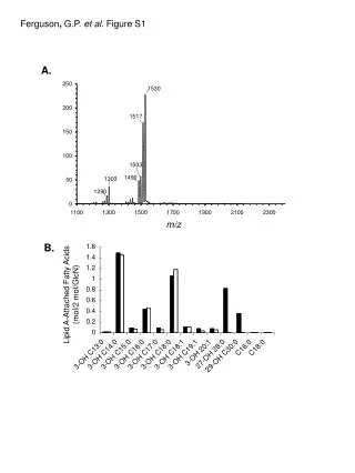
Download
1 / 17
170 likes | 337 Views
NRL and Global Land Cover Network (GLCN) activities, standards, tools and products Renato Cumani Environment Officer Land and Water Division (NRL) Natural Resources and Environment Department (NR) FAO Vienna, June 2011. Global Land Cover Network (GLCN). Main Objectives:

E N D
NRL and Global Land Cover Network (GLCN) activities, standards, tools and products Renato Cumani Environment Officer Land and Water Division (NRL) Natural Resources and Environment Department (NR) FAO Vienna, June 2011
Global Land Cover Network (GLCN) Main Objectives: • To improve linkages between global, regional and national studies on land cover and the environment • To improve standardization, homogenization, compatibility and efficiency of information provided by different applications • To provide information that improves design and efficiency of sampling for validation of land cover products at global, regional and national levels. • To increase use and sharing of remote sensing data and its derived datasets • To provide comparable products at global, regional, and national and lower levels • To undertake capacity development and institution strengthening to maximize benefits for developing countries • To support operational development and use by national stakeholders of products emanating from the programme multi-date landsat imagery
Methodology/standards LCCS • Comprehensive methodology for description, characterization, classification and comparison of most land cover features identified anywhere in the world, at any scale or level of detail. Basis for comparative classification. • Created in response to a need for a harmonized and standardized collection and reporting on the status of land cover • Comparison and correlation of land cover classes between different systems/approaches
LCCS3 • LCCS is widely adopted by both national and international organizations • Land Cover Meta-Language (LCML) submitted to become an International Standard through the TC-211 Technical Committee of the International Organization for Standardization (ISO) – Currently at the Draft Internal Standard stage • LCCS 3 Software – released (JAVA application based on LCML (UML) • LCCS 3 Extension for ArcGIS Available • LCCS 3 is being migrated for the Land Cover mapping Toolbox
awareness workshops, training resources and sessions Regional awareness workshops by FAO staff on land cover mapping methodology, standards and tools National on-the-job trainings to support national mapping programmes Project coordination and backstopping QA&QC Sudan Uruguay Nepal Capacity building
Communication material, user manuals, tutorials, etc.. Brochures Manuals & Tutorials Posters Presentations Reports Newsletters Websites Outreach
GeoNetwork – FAO metadata catalogueDissemination of spatial information Facilitates access to information • Provides Internet access to interactive maps, satellite imagery and related spatial databases maintained by FAO and its partners • The site is powered by GeoNetwork opensource, which is developed by FAO and other UN agencies • Based on the principles of Free and Open Source Software (FOSS) and International and Open Standards for services and protocols
THEMATIC & CART. ASPECT INTERPRETATION EFFICIENCY MULTI USER DATA BASE BROWSER ACCURACY ANALISYS Advanc. Map Land cover class. Syst. DATA BASE Database Acc. GATEW. Prog. DATA PRODUCERS DATA USERS Land cover and land cover change production chain toolbox
AFRICOVER: East Africa Module • Project facts: • Mapped area: 8.5 million Km2 • Countries covered: 10 • Landsat Scenes used: more than 400 • Project budget: 9.270.000 USD • Period of activity: 1998-2004 • Result: Multipurpose Africover Database for the Environmental Resources (MADE) produced at a 1:200,000 scale (1:100,000 for small countries and specific areas) Burundi, DR Congo, Egypt, Eritrea, Kenya, Rwanda, Somalia, Sudan, Tanzania and Uganda.
AFRICOVER data users : Percent of requests by type of organizations
GLCN-RHAP: Himalayan Land Cover Change The Himalaya RHAP initiative aims to act as a catalyst in the region engaging national and international organization in a clear and transparent process towards an effective harmonization process with a defined set of regional stakeholder required outputs.
Land Cover and Land Cover Change • Wall-to-wall – LCCS – Object Based Classification – Mapping Device Change Analysis Tools • Senegal (2005) • South Sudan (2010) • North Sudan (2010) • Kenya (2010) • Ethiopia (2005 – Spot Imagery • Tunisia (2005) • South Africa (2005) – limited classes • Cambodia (2009) • Himalayan Region (2005) • Cuba (2008/10)
Starting up / Planned • Afghanistan • Fouta Djallon (West Africa) • Gambia • Tanzania • Mekong River Basin
Thank you More information: www.fao.org/nr/nr-home/en/ www.glcn.org Contact: Renato Cumani Email: renato.cumani@fao.org