Download
1 / 21
300 likes | 361 Views
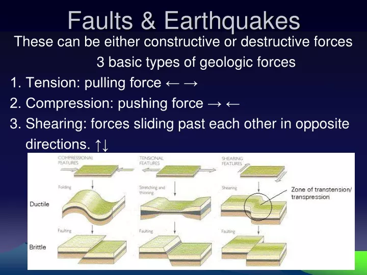
Faults & Earthquakes. These can be either constructive or destructive forces 3 basic types of geologic forces 1. Tension: pulling force ← → 2. Compression: pushing force → ← 3. Shearing: forces sliding past each other in opposite directions. ↑↓.

E N D
Faults & Earthquakes These can be either constructive or destructive forces 3 basic types of geologic forces 1. Tension: pulling force ← → 2. Compression: pushing force → ← 3. Shearing: forces sliding past each other in opposite directions. ↑↓
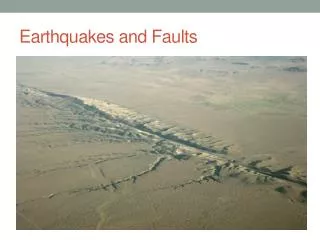
Fault: a fracture in earth’s crust where movement occurs 3 types of Faults: 1. Normal (tension) fault: one side drops in relation to the other. 2. Reverse (compression) fault: one side pushes up in relation to the other. 3. Strike-Slip (shear): fault: horizontal shift in opposite directions.
PLATE TECTONIC STRESSES • Plate boundaries and faults (= cracks where plate sections are moving in different directions) cause friction as plates move • Plates in a fault zone have STICK-SLIP motion • Periods of no movement (stick) and fast movement (slip) • Energy stored as plates stick, • Energy released as plates slip
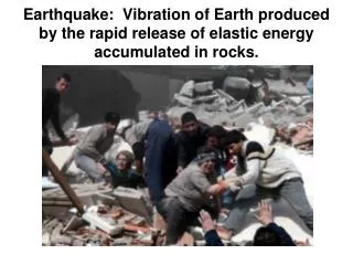
EARTHQUAKES sudden movement or shaking of the Earth • Caused by plate tectonic stresses • Located at plate boundaries & faults within plates • Resulting in breakage of the Earth’s brittle crust • https://www.youtube.com/watch?v=CtBXTvtFaCU&nohtml5=False (2 ½ minute earthquake video)
SEISMIC WAVESproduced by the release of energy • move out in circles from the point of rupture (focus) • Types of waves: surface & body(travel inside & through earth’s layers) • - P waves: longitudinal – compression (back and forth movement of rock) arrives 1st; travels thru solid, liquid, gas • S waves: sideways (transverse – shear) movement of rock; travel thru solids only; arrives 2nd. • L waves (surface): when both P & S waves reach the surface
EARTHQUAKEWAVES • Seismographs record earthquake waves • Seismograms show: Amplitude of waves • (how much rock moves or vibrates) • - Distance to the epicenter - • Earthquake direction • How to read a Seismograph: • - P & S (body waves) move • through earth & arrive first. • P & S waves used to calculate magnitude of • earthquake. • - Amplitude = height of wave (how much the rock moves; size of vibration)
EARTHQUAKE WAVES • FOCUS = place deep within the Earth and along the fault where rupture occurs • EPICENTER = geographic point on surface directly above focus • The epicenter is determined by taking seismic readings from at least 3 stations are taken and circles drawn from those stations based on time intervals from those stations. • The point where all circles intersect is the epicenter. This also referred to as Triangulation. https://www.youtube.com/watch?v=694yaY2ylTg&nohtml5=False (locating the epicenter vide o (3 1/2 minutes)
EARTHQUAKEMAGNITUDE measures the size of seismic waves the energy released by the earthquake • Richter scale=measurement of energy released based upon wave amplitude (size of vibration) • <2 to ~10 • Amplitude of wave goes up by 10 (Logarithmic scale) • What you need: • Amplitude (size of vibration = wave height) • Time between arrival of 1st P and 1st S waves
Mercalli Scale: Measures the intensity of an earthquake based on qualitative data (damage to man-made structures) MERCALLI VS. RICHTER
ISOSEISMIC MAPS • Connects areas with the same Modified Mercalli number • Areas are colored according to Modified Mercalli number Loma Prieta Earthquake 1989 show the distribution of intensities
EARTHQUAKE DAMAGE • Most caused by SURFACE waves (arrive last) • Landslides • Building damage • Liquefaction
LIQUEFACTION The process that occurs during earthquakes when loose soil particles (sand and soil, not bedrock) turn into a watery, slurry mix as a result of the seismic vibrations. • Results in a loss of soil strength & the ability of the soil to support weight • https://www.youtube.com/watch?v=4Uwxr42JqYQ (liquifaction video 2 ¼ minutes) • (liquifaction video 2: 1 ½ minutes) https://www.youtube.com/watch?v=536xSZ_XkSs
Most volcanoes and earthquakes occur in the ring of fire, an area circling the Pacific Ocean. • New Madrid fault is an area of active earthquake activity in the American mid-west. • A Tsunami is a giant tidal wave often caused by an underwater earthquake. http://video.nationalgeographic.com/video/101-videos/tsunami-101 (Tsunami video 2 ¾ minutes)
Orogeny: Mountain Building Processes: 4 types of Mountains: 1. Folded: by compression forces – ex. Himalayas 2. Fault Block: by tension forces – ex. Grand Tetons 3. Volcanic Mountains: by eruption – ex. mountains in the ring of fire 4. Plutonic: by magma pushing crust up, but no lava escapes – ex. Sierra Nevada’s.
A volcano is an opening in Earth’s crust that has released molten rock. • Magma is melted rock below Earth’s crust • Lava is magma that extrudes onto Earth’s surface from a volcanic vent • A vent is an opening in a volcano where lava escapes • Viscosity is a measure of a fluid's resistance to flow. The higher the viscosity the slower the fluid flows. • https://www.youtube.com/watch?v=WgktM2luLok (3 ¼ minute volcano video)
3 types of magma: • Basaltic: found in oceanic crust, non- explosive, low viscosity, less than 50% silica. 2. Andesitic: found at oceanic - continental plate boundaries, explosive, medium viscosity, 50% - 60% silica. 3. Rhyolitic found in continetal crust, explosive, high viscosity, more than 60% silica.
A caldera is a volcanic crater that forms when the summit or side of a volcano collapses into the emptied magma chamber. • Tephra are pieces of solidified lava, rock, and ash thrown into the air during a violent eruption. • A pyroclastic flow is rapidly moving clouds of tephra mixed with hot, suffocating gases. https://www.youtube.com/watch?v=IhU6jml6NY4 Mt. St Helens Eruption (2 ¾ minutes)
Most volcanoes are found along plate boundaries, the highest density is known as the ring of fire, an area encircling the Pacific Ocean. A hot spot is a volcano that occurs away from a plate boundary at a thin spot in the lithosphere. (ex. The Hawaiian Islands)
3 types of volcanoes: 1. A shield volcano has broad, gently sloping sides and a near circular base formed from non-explosive (effusive) eruptions 2. A. composite (strato) volcano is formed by layers of hardened chunks of lava from violent (explosive) eruptions alternating with layers of sediment and lava that oozed down slope before solidifying. Very dangerous because they can remain inactive for centuries, then suddenly come back to life. (ex.: Mt. Vesuvius) 3. A cinder cone volcano has steep sides formed quickly when cinder cones are ejected into the air, fall back to Earth and pile up around the vent. Generally small and form on or near large volcanoes.
Effects of Volcanoes 1. Harmful: Increases earthquake activity. Destruction to plants, animals & land from lava, gases, explosion, ash, tsunamis, lahars (mudflows with water),etc. 2. Helpful: Enriches soil for farming with minerals such as potassium, phosphorous, etc. Clears land for new growth. Geothermal energy. https://www.youtube.com/watch?v=_PxDGiVQNg8 (Yellowstone Super Volcano video: 4 minutes)