Download
1 / 24
240 likes | 244 Views
This case study focuses on the transport and evolution of wildfire plumes in Northern California, specifically during the June 2008 wildfires. The study aims to understand the effects of wildfires on air quality in the region. The NASA/JPL TES instrument and the Real-time Air Quality Modeling System (RAQMS) are used for analysis and prediction.

E N D
TES Science Team Meeting February 23, 2009 Case Study During Northern California Wildfires of June 2008/Plans for CalNex 2010 Greg Osterman Jet Propulsion Laboratory/California Institute of Technology Brad Pierce NOAA/NESDIS Acknowledgments: DC-8/ARCTAS, ARC-IONS, NOAA/NESDIS, NASA-Langley, JPL/TES Collaborators
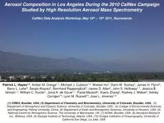
Case Study – June 2008 CA Wildfires • Particularly dry conditions in Northern/Central CA in 2008 • Major fires started on May 22, June 6 • Dry low pressure system moved through on June 20-21 producing lightning that sparked fires • Fires burned into August 2008 – 800,000 acres burned • TES Special Observation caught plume of high CO from CA wildfires on June 23, 2008 • TES may have sampled plume again on way back into Canada • DC-8 flew over fires on June 22, 2008 • Ozonesonde data from Trinidad Head, CA • CALIPSO, AIRS, MODIS • RAQMS, WRF-Chem • Goals: • Study transport and evolution of the CA wildfire plumes • Effects of wildfires on CA air quality
Real-time Air Quality Modeling System (RAQMS) • Online global chemical and aerosol assimilation/forecasting system • University of Wisconsin sigma-theta hybrid coordinate model (UW-Hybrid) dynamical core • Unified stratosphere/troposphere chemical prediction scheme (LaRC-Combo) developed at NASA LaRC • Aerosol prediction scheme (GOCART) developed by Mian Chin (NASA GSFC). • Statistical Digital Filter assimilation system developed by James Stobie (NASA/GFSC) • RAQMS has been used to support airborne field missions [Pierce et al, 2003, 2007, 2008], develop capabilities for assimilating satellite trace gas and aerosol retrievals [Fishman et al., 2008, Sunita et al., 2008] and assess the impact of global chemical analyses on regional air quality predictions [Song et al., 2008, Tang et al., 2008] Will focus on results from the June 2008 NASA/CARB ARCTAS-CA field mission
RAQMS Real-time O3 Assimilation/Prediction 5-day 2ox2o Global Met/Chem Forecast OMI cloud cleared O3 Column 2x2 degree Global online strat/trop chemistry Aerosol/photolysis feedback Statistical Digital Filter (SDF) univariate OI assimilation
RAQMS Real-time Aerosol Optical Depth (AOD) Assimilation/Prediction 5-day 2ox2o Global Met/Aerosol Forecast 2x2 degree Global online aerosol (GOCART) Statistical Digital Filter (SDF) univariate OI assimilation applied to SO4, Dust, BC, OC (not Sea Salt)
RAQMS vs DC8 CO Measurements ARCTAS-CA Flight 20080622 • RAQMS analysis captures large scale lower tropospheric CO enhancements observed by the DC8. • RAQMS underestimates CO mixing ratios associated with wildfire plume In situ data provided by G. Diskin (NASA/LaRC)
RAQMS vs DC8 O3 Measurements ARCTAS-CA Flight 20080622 • RAQMS analysis captures large scale upper tropospheric ozone enhancements observed by the DC8. • RAQMS does not resolve fine scale structure within the PBL Insitu data provided by A. Weinheimer (NCAR)
RAQMS Black Carbon vs DC8 SP2 Measurements ARCTAS-CA Flight 20080622 • RAQMS analysis overestimates • black carbon aerosol associated with local wildfire activity • DC8 SP2 measurements support analyzed black carbon aerosol enhancement aloft Insitu data provided by Y. Kondo (Univ Tokyo)
TES and RAQMS CO June 23, 2008
TES and RAQMS O3 June 23, 2008
TES and RAQMS CO July 5, 2008
TES and RAQMS O3 July 5, 2008
Ozonesonde Measurement from Trinidad Head, CA on June 28, 2009 Wildfire enhancement?
Science to Support Decisions CalNex Global Modeling and Satellite Assimilation R. Bradley Pierce NOAA/NESDIS CalNex 2010 Public MeetingFebruary 5, 2009 Sacramento, CA
CalNex 2010 – Planning MeetingSacramento, CA – Feb 5, 2009 • NOAA P3, Twin Otter, Ron Brown, Los Angeles Area Supersite • 130-150 flight hours for P3 • Dates: May 1 – June 30 (dependent on hurricane season) • Based in either Long Beach or Ontario • Work with California Air Resources Board on using satellite data in modeling efforts (applications of satellite data) • Range: entire west coast including Mexico • Science Goals (partial list): • Emissions • Chemical Transformation and Climate Processes • How important are chemical processes occurring at night in determining transport and / or loss of nitrogen oxides, reactive VOC and ozone? Do regional models in California adequately represent these processes and their effect on air quality? • What are the sources and physical mechanisms that contribute to high ozone concentrations aloft that have been observed in Central and Southern California? • Transport and Meteorology (including boundary conditions)
Illustration of CalNex mission Support activities • Flight Planning (long-range transport focus) • Data synthesis (linking remote satellite, aircraft and ground-based measurements) Arctic Research of the Composition of the Troposphere from Aircraft and Satellites- California (ARCTAS-CA) • ARCTAS-CA was CARB/ NASA collaboration dedicated to California air quality and climate change objectives • Field campaign during June 15-30, 2008
Lagrangian estimates of background chemistry Los Angeles Basin, CA June 22, 2008 Near coincident TES Step&Stare Observations RAQMS chemical analyses are used to provide estimates of background composition along ensemble back trajectories that are initialized from surface ozone monitoring stations within the Los Angeles Basin [ala Pierce et al., submitted to TEXAQS Special Issue, 2008]
Los Angeles Basin, CA June 22, 2008 SFC Lagrangian Evolution 850mb Lagrangian Evolution Continental BL/FT Marine FT Continental BL Marine BL Residual O3 above continental PBL O3 Production within Oregon/Northern CA PBL
Verification of RAQMS O3 along TES Pacific Step&Stare observations (June 13, 15, 17, 2008) RAQMS vs TES 22Z June 15, 2008 LAB SFC Source Region • RAQMS is in good agreement with TES at LAB SFC Source Region • TES shows sharper O3 gradients at the tropopause
Verification of RAQMS CO along TES Continental Step&Stare observations (June 13, 15, 17, 2008) RAQMS vs TES 20Z June 15, 2008 LAB 850mb Source Region • RAQMS overestimates upper tropospheric • CO at LAB 850mb Source Region
TES Plans for CalNex 2010 Propose to support the campaign with special observations Near real time processing of TES data for assimilation into RAQMS? Provide global/regional view of troposphere for analysis/planning in the field. Analysis after the mission similar to that from TexAQS II (2006) Work with California Air Resources Board on using satellite data in modeling efforts (applications of satellite data)