Download
1 / 6
60 likes | 246 Views
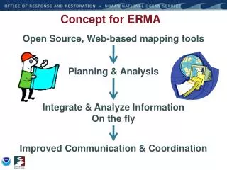
ERMA Schematic View. ERMA GOMEX: Deployment Timeline. GOMEX ERMA Available for ICP Data upload 4/22. ERMA integrated With FWS IPAC query tool. MMSI zoom To ship function created. Supporting Simple KML. Select by Polygon. Deployed ERMA staff To ICPs data ingest.

E N D
ERMA GOMEX: Deployment Timeline GOMEX ERMA Available for ICP Data upload 4/22 ERMA integrated With FWS IPAC query tool MMSI zoom To ship functioncreated Supporting Simple KML Select by Polygon Deployed ERMA staff To ICPs data ingest BP databasereplication Animations, Slide show, Find SONS ExerciseMarch 23-25th Geoplatform.gov/ Gulfresponse April May June July Aug Sept Oct Nov Dec Jan Feb March Creation of Ship track tool webpage DWH BlowoutApril 20th Ingest customdata feeds NAIS feed Filtered for Response Enhanced NRDA NOAA sFTP site deployed Off-site Support ERMA Populated With base GRP, ESI, Etc. 4/24 Customized Ingest From Injury Studies Getfeature info support ERMA down 2.5 hours power failure • Key to development timeline was ERMA Adaptability in scaling: • Customizable, free Open Source software • Ability to code for non-OGC and customized vendor feeds Completely redesigned backend software architecture to cloned/replicated databases after Geoplatform.gov release and redeployed overnight because 3.4 million hits on first day of launch
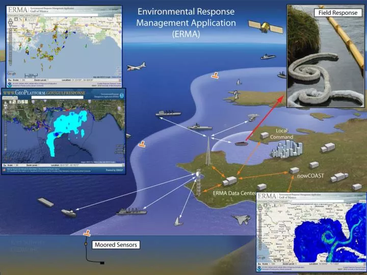
Primary Source Response Daily Data Source Location Display Location Deep Water Horizon Daily Data pushed into ERMA from various sources SFTP/ Replicate feed BP/ ICPs Task Force ERMA Responder Decon locations/ Waste Area BP/ ICPs Replicate feed ERMA Responder BP/ ICPs ERMA Responder Emergency Response Teams Replicate feed BP/ICPs Beach Cleanup ERMA Responder SFTP/ Replicate feed BP/ ICPs Field Boom Data ERMA Responder SFTP/ Replicate feed BP/ ICPs Burn/ Dispersant ERMA Responder SFTP/ Replicate feed BP/ ICPs WEBEOC/ Phone log ERMA Responder Replicate feed BP Platform Observations SFTP NOAA ERMA Responder ERMA Public NESDIS Anomaly Analysis SFTP NOAA ERMA Responder ERMA Public Fishery Closures SFTP NOAA Trajectories ERMA Responder SFTP ERMA Public NOAA Protected Resources Impacts ERMA Public SFTP ERMA Responder NOAA Loop Current SFTP ERMA Responder ERMA Public NOAA Subsurface Monitoring SFTP ERMA Responder ERMA Public* NOAA Helo Oil Obs & Photos SFTP ERMA Responder NOAA/ University Buoy/ AXBT Data ERMA Public FTP ERMA Responder NOAA/ BP SCAT Obs and Photos SFTP ERMA Responder ERMA Public* BP/ ICPs VOOs tracking Modified WMS ERMA Responder USCG NAIS Feed Modified WMS ERMA Public* ERMA Responder IRSCC Planned Remote Sensing Email KML ERMA Responder AFS/ AMOC Air Operations Feed Modified WMS ERMA Responder NGA NGA Satellite Analysis SFTP ERMA Responder NGA Imagery Derived Booms NGA SFTP * Slightly modified for public EPA SFTP/WMS Monitoring data
NOAA DWH ERMA Team NOAA Seattle Spatial Data Team, ERMA Leads, & Developers UNH ERMA Developers National Incident Command, Washington D.C. ERMA Staff came from all across NOAA and beyond • NOS, NMFS, NWS, CIO, States • Over 80 staff volunteered for rotations • Command posts • National Incident Command • Remote Field Offices • Home Offices Command Post Teams: Robert, Houma, Venice, Mobile, Miami
ERMA DWH Lessons Learned • Non-technical Interface • GIS background not necessary to navigate • “How to” sessions in command posts to socialize ease of use • Scalable Access • Quick to stand up foundation • Public Facing data needed- Geoplatform.gov/Gulfresponse • Varying data access levels based on account type (Public, Responder, NRDA, Trustee) • Cost Effective Open Source Software • Customizable Programming & Modular developmentPublic Facing or specialized sites (Climate Change, Wildfires, Marine Debris, Tsunami, Flooding)
Data & Mapping Technology Best Practices • Documented Data Development • Must have metadata! • Data Accessibility • Make data available so others can use it • Planning and Preparedness • Not just in crisis mode • Data Sharing Agreements • Focus on what you know, share with others for what you don’t, avoid duplication • Use the success and failures to ensure that we develop the tools and the data necessary to respond efficiently in the future


![Schematic view of particle production in the atmosphere [8]](https://cdn3.slideserve.com/6902772/slide1-dt.jpg)