Download

1 / 31
310 likes | 313 Views
This warmup activity introduces students to the physical characteristics, population, land size, and GDP of Russia and Central Asian countries. It also provides information on significant geographical features such as Chernozem soil, Siberia, mountains, rivers, lakes, and climate.

E N D
The next slide is the Russia Map Review Warmup. After 10-15 minutes, have students compare their answers to the next page! Warmup # 14!
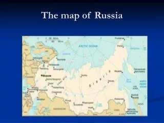
When working on the map note the borders of Russia – lined in red below:
Russia and Central Asia Physical Characteristics
The most important countries of Russia and Central Asia are Russia, Kazakhstan, Turkmenistan, and Uzbekistan.
The level of importance of each is determined by GDP, land size, and population. Do this for HW! You know where to go! Regional Data File… pages 365 and pages 434-437.
Population – Population refers to the total number of people living in a country. Determine the countries with the largest population. Kazakhstan - Russia – Uzbekistan -
Land Size – land size refers to the total square miles of a country. Pages 365 and pages 434-437 to determine what the largest countries are in land size. Russia – Kazakhstan – Turkmenistan -
GDP – Gross Domestic Product refers to the total value of goods and services produced in a country in one year. Russia – Kazakhstan – Turkmenistan –
Land Size in asia • Russia covers 2 continents - Europe and Asia • 25% of Russia is located in Europe and 80% of it’s population live there • Russia spans 11 time zones! This area is named “Russian Federation” and shortened to “Russia”
Chernozem found in the Steppes • Chernozem (chur-NO-zum) is found in the Steppe climate region. • Chernozem is Slavic for “black earth” • This steppe, or grassland region of Southwest Asia has become one of the worlds major wheat producing areas because the soil is very fertile. Dark Soil on Top
Calling all South Team Members! Please deliver A to Z folders! Remember they are located in black shelves by butterfly bulletin board. Turn to the letter C! Maps will be delivered for Chernozem. Save the 2nd map for another word in these notes!
Siberia • Siberia is the land that lies east of the Ural Mountains. • It means “sleeping land”. • Known for its harsh & cold climates. • Natural resources: many minerals, natural gas, oil, and mining Video to show! Located in the flash drive in same Folder as this Power Point!
Mountains The Ural Mts divide Europe from Asia Caucasus Mountains from space The Caucasus Mountains divide Russia from Southwest Asia
RIVERS The Volga River flows south. It is very important for transportation and hydroelectric power. Amur River is the most important waterway of the Russian far-east. It creates a border between Russia and China. The River Ob (rhymes with globe) is a major Siberian River that flows north into the Arctic Ocean.
Lake Baikal(bye-call) The Jewel of Siberia It’s the deepest Lake in the WORLD - over 5,000 feet deep! The lake holds 1/6th of the world’s freshwater!!! Video to show! Located in the flash drive in same Folder as this Power Point!
Bering Strait (bear-ing) • Separates Asia from North America • It froze during the Ice Age which allowed humans to cross over to the Americas BeringStrait Alaska Kamchatka Peninsula
Climate Climates vary because the region is so large! TUNDRA – in the extreme northern regions. Remember PERMAFROST! SUBARCTIC – TAIGA(huge forests of coniferous trees) Mostly in Siberia.
Climate cont… Climates vary because the region is so large! HUMID CONTINENTAL – SEASONS! SEMI-ARID(STEPPE) – Temperate grassland found mostly in Central Asia. Chernozem soil helps to make this area an area of high agricultural activity.
Climate cont… Climates vary because the region is so large! ARID(DESERT) – Western part of Central Asia. Kara Kum and Kyzyl Kum.