Download
1 / 3
30 likes | 168 Views
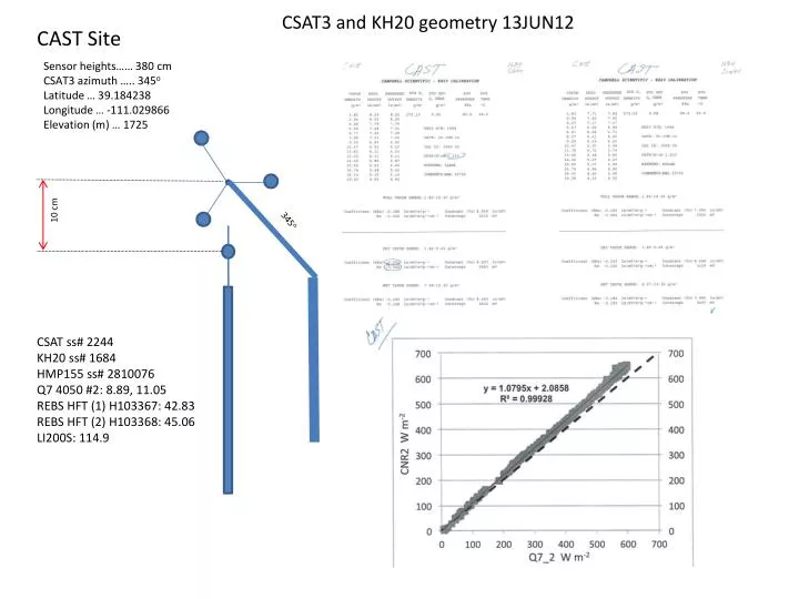
CSAT3 and KH20 geometry 13JUN12. CAST Site. Sensor heights…… 380 cm CSAT3 azimuth ….. 345 o Latitude … 39.184238 Longitude … -111.029866 Elevation (m) … 1725. 10 cm. 345 o. CSAT ss# 2244 KH20 ss# 1684 HMP155 ss# 2810076 Q7 4050 #2: 8.89, 11.05 REBS HFT (1) H103367: 42.83

E N D
CSAT3 and KH20 geometry 13JUN12 CAST Site Sensor heights…… 380 cm CSAT3 azimuth ….. 345o Latitude … 39.184238 Longitude … -111.029866 Elevation (m) … 1725 10 cm 345o CSAT ss# 2244 KH20 ss# 1684 HMP155 ss# 2810076 Q7 4050 #2: 8.89, 11.05 REBS HFT (1) H103367: 42.83 REBS HFT (2) H103368: 45.06 LI200S: 114.9
CSAT3 and KH20 geometry 13JUN12 HILO Site Sensor heights…… 386 cm CSAT3 azimuth ….. 194o Latitude … 39.376670 Longitude … -111.070932 Elevation (m) … 1929 10 cm 194o CSAT ss# 2245 KH20 ss# 1686 HMP155 ss# G2810038 Q7 4049 #1: 8.86, 11.02 REBS HFT (1) H103365: 41.20 REBS HFT (2) H103366: 42.36 LI200S: 124.1
ROCK Site CSAT3 and KH20 geometry 13JUN12 Sensor heights…… 380 cm CSAT3 azimuth ….. 6o Latitude … 39.375967 Longitude … -111.055854 Elevation (m) … 1958 10 cm 345o CSAT ss# 2238 KH20 ss# 1686 HMP155 ss# G2810061 Q7 4050 #2: 8.66, 10.71 REBS HFT (1) H103369: 44.25 REBS HFT (2) H103370: 41.32 LI200X: 200.0