Download
1 / 20
200 likes | 206 Views
Development of a Satellite Passive Microwave Snowfall Detection Algorithm. Cezar Kongoli 1 , Huan Meng 2 , Jun Dong 1 , Ralph Ferraro 2 , 1 University of Maryland/ESSIC/Cooperative Institute for Climate and Satellites 2 NOAA/National Environmental Satellite, Data, and Information Service.

E N D
Development of a Satellite Passive Microwave Snowfall Detection Algorithm Cezar Kongoli1, Huan Meng2, Jun Dong1, Ralph Ferraro2, 1University of Maryland/ESSIC/Cooperative Institute for Climate and Satellites 2NOAA/National Environmental Satellite, Data, and Information Service
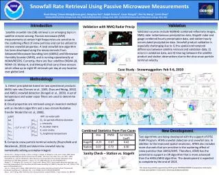
Product Overview • Probability-based Snowfall Detected (SD) area over global land; • Snowfall mask for 1DVAR-based SnowFall Rate (SFR) (Meng et al. 2016, submitted to JGR) generated from AMSU/MHSsensor pair (POES/Metop) and ATMS (S-NPP and the future JPSS satellites); • The five satellites produce up to tensnowfall rate estimates per day at mid-latitudes and more estimates at higher latitudes; • A similar SSMIS-based SD/SFR product is under development. Retrieved Snowfall Rate NEXRAD Reflectivity 2
A Brief Historical Perspective (1) • Operational snow cover algorithms from VIS/IR and passive MW have over 40-year history. • Real progress on snowfall determinations began only with the launch of satellites carrying AMSU-A/B/MHS instruments. WHY? • Very difficult to discriminate winter snowfall from no-snowfall clouds or snow on the ground using VIS/IR measurements; • Passive MW measurements at 89 GHz and above are sensitive to snowfall-sized ice particles. WV channels around 180 GHz are even better since WV screens out surface effects.
A Brief Historical Perspective (2) • MSPPS AMSU snowfall detection algorithm was the first operational product (Kongoli et al., 2003; Ferraro et al. 2005). Historical MSPPS images available at: http://www.star.nesdis.noaa.gov/corp/scsb/mspps/ • A decision tree binary classification with retrievals limited to warmer weather. Colder weather retrievals were found too noisy and removed from the product.
New Snowfall Detection Algorithm • Coupled principal components and logistic regression model (Kongoli et al., 2015); • Input data: 53.6 GHz and all high frequency channels above 89 (MHS) /88.2 GHz (ATMS); • Model output is the probability of snowfall; preset thresholds for snowfall; • Training data sets are composed of matching satellite and ground snowfall observation data; Snowfall Freq. vs. 2 m RH • Additional filters and screenings to improve the accuracy of snowfall detection.
Extension to Cold Regime • Satellite measurements exhibit different characteristics depending on atmospheric conditions: • Scattering signal dominates in relatively warm and moist atmosphere • Emission signal dominates in cold and dry atmosphere (or with abundant supercooled liquid water) • Limb-corrected temperature sounding channel 53.6 GHz (Tb53L) as a proxy for atmospheric temperature Tb53L is used to define retrieval regimes: • Too warm, no snow (> 252K) • Warm regime (244K ~ 252K) • Cold regime (240K ~ 244K) • Too cold, no retrieval (< 240K) SD models are trained separately for cold and warm regimes. Snowfall Freq. vs. Tb53L
Tb53L a strong predictor of near surface temperature Snowfall No-Snowfall
Two-Regime Hypothesis Strong Empirical Evidence: Change of direction in the correlation between measured SFR and TBs
Extension to Cold Regime • Cold regime extension is a new development for ATMS SFR, also applied to the AMSU/MHS algorithm No Cold Extension With Cold Extension Radar Reflectivity
New Snowfall Detection Procedure • SD Procedure • Apply filters and determine snowfall regime; • Run the statistical model to derive snowfall probability; • Compare with probability threshold to obtain Snowfall Detection Index • Apply NWP based screening to derive the final SD ‘product’. Snowfall Rate Snowfall Probability Snowfall Detection Index NEXRAD Composite Reflectivity
SD Validation (1) • SD algorithm was evaluated with in-situ data as ground truth for snowfall events over CONUS and Alaska that spread out over different regions and time of year; • 62% of ground truth data is very light snowfall reported as “trace” – challenging to detect for satellite product; • Evaluation included an investigation of error sources and sensitivity to the probability of snowfall, snowfall intensity, elevation, zenith angle and additional model-based screening. • Statistics:
SD Validation (2) • Other Conclusions • SD performance is comparable over high and low elevation areas; • Statistics improve with snowfall rate; • Statistics degrade for shallow to moderate cloud snowfall; • The most effective screening parameters are cloud thickness and relative humidity;
On-going/Future Work • Hybrid weather forecast-satellite snowfall detection model • Probability Logistic Regression model based on Numerical Weather Prediction (NWP) model data; • Coupled Principal Components and Probability Logistic Regression model based on satellite TBs; • Hybrid model: Optimal weighting of both: • Prob_hybrid = W1*Prob_wea +W2*Prob_sat • W1+W2 = 1
Weather-based Model Statistics • GFS-derived weather variables considered: cloud thickness, relative humidity and vertical velocity at 1,2 and 3 km height, cloud top height and temperature; • 1-km relative humidity and cloud thickness the most statistically significant to discriminate snowfall from no-snowfall cases including moderate to shallow-cloud snowfall (cloud thickness less than 3.5 km).
Weather-based model Statistics (2) No-snowfall Snowfall Forecast relative humidity histograms at 1 km height for no-snowfall (left) and snowfall (right) cases. For rel. humidity at and above 90 %, 75% of all snowfall cases are detected with 25% false alarm.
Weather-based Model Statistics (3) No-snowfall Snowfall GFS-derived cloud thickness for no-snowfall (left) and snowfall (right) cases. For cloud height over 3500 m, 55% of all snowfall cases are detected with less than 10% false alarm
Hybrid Model Application Examples • The blended (0.5:0.5) weather-satellite snowfall detection model for both shallow and thick-cloud snowfall Deep-Cloud Snowfall Case Shallow-Cloud Snowfall Case Deep-Cloud Snowfall Case Radar Reflectivity
Future Development • Development of SSMIS and GMI algorithms • Development of ocean algorithms
Acknowledgement • JPSS Proving Ground and Risk Reduction Program • NOAA/NESDIS • NASA Thank You!