Download
1 / 20
200 likes | 384 Views
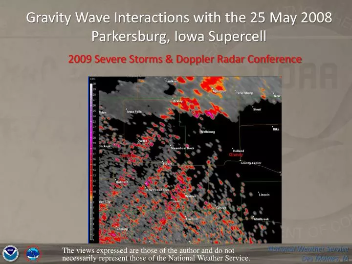
Gravity Wave Interactions with the 25 May 2008 Parkersburg, Iowa Supercell. 2009 Severe Storms & Doppler Radar Conference. The views expressed are those of the author and do not necessarily represent those of the National Weather Service. Outline Mesoscale/gravity wave environment

E N D
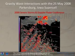
Gravity Wave Interactions with the 25 May 2008 Parkersburg, Iowa Supercell 2009 Severe Storms & Doppler Radar Conference The views expressed are those of the author and do not necessarily represent those of the National Weather Service.
Outline • Mesoscale/gravity wave environment • Gravity wave evidence/Nature of gravity waves • Web cam and Visible Satellite images • Gravity waves/spectrum width evidence • Gravity waves/mesocyclone evolution • Closing comments
MSLP, Surface Observations, Surface Analysis, and Visible Satellite Imagery, 2200 UTC 25 May 2008 (cyan arrow indicates location of Parkersburg) Analysis courtesy of SOO Karl Jungbluth Near storm environment values from SPC Mesoanalysis page compared to studies from Davies (2002) and Rasmussen (2003)
Gravity Wave Environment Gravity waves are the oscillations of air parcels by the lifting force of buoyancy and the restoring force of gravity. • Visible satellite imagery indicated apparent gravity waves that initiated near Hastings and Hebron, Nebraska around 1500 UTC • Consistent with the synoptic patterns favorable for gravity waves outlined in Schaub (2005), with the initiation region was just ahead of a cold front and in the right-rear quad of a 300-mb jet max. RUC Bufkit Soundings 21z/22z at Waterloo Stable layer A proximity sounding near Fort Dodge, Iowa at 1700 UTC also indicated a stable layer below 800 mb conducive for ducted gravity waves
Koch and Saleeby (2001) indicated a Duct Factor of 10 to 15 would support strong ducting Koch and O’Handley (1997) developed a “duct factor”, which is a measure of the duct strength in the stable layer, and the degree of conditional instability in the 700-mb to 400-mb layer. Values approached 20 degrees C near Parkersburg at 2200 UTC, more than sufficient to support gravity wave development and propagation.
Gravity Wave Evidence/Nature of Gravity Waves • Surrounding surface observations indicate this feature was not an outflow boundary, as there was no significant change in wind speed and direction, or temperature and dewpoint associated with small scale radar features • The speed of propagation (around 50-60 kts) was faster than the mean wind in the layer (WSW under 30 kts) • The stable layer necessary for continued ducting of the gravity waves was likely well elevated at least initially (FOD sounding), perhaps explaining why there were no significant pressure perturbations in this area. The atmosphere would also have a difficult time responding with significant pressure changes given the fast movement of the waves. (Coleman, 2009) • As the waves approached Parkersburg, proximity soundings indicate the stable layer lowering, and pressure perturbations were noted at several locations
1-minute Pressure perturbations from ASOS/AWOS sites around Parkersburg ASOS observations at the Waterloo Airport indicate a familiar pattern associated with gravity waves, with surface pressure rises near the wave ridge and pressure falls near the wave trough (Schaub 2005) SPECI KALO 252142Z 16011G18KT 5SM HZ BKN017 24/21 A2971 RMK AO2 LTG DSNT W-N PRESRR METAR KALO 252154Z 14014KT 5SM VCTS HZ SCT019 BKN023 BKN028 24/21 A2967 RMK AO2 LTG DSNT SW-N TSB50 PRESFR SLP044 T02390206 tornado moves into Parkersburg at 2156Z Initial tornado at 2146Z south of Aplington 2235z 81kt wind gust
Visible Imagery from 2140 Z Tama webcam loop from Iowa Environmental Mesonet T
Storms fired just east of Fort Dodge around 2000 UTC, right after the second gravity wave moved through, and near a pre-frontal trough 1st wave 2nd wave wave movement Visible satellite imagery, 1955 UTC 25 May 2008
T By 2140 UTC, just prior to tornado formation, the lead gravity wave had pushed east of the primary warm front, which extended north to south near the location of the first tornado 2nd gravity wave not apparent on visible imagery, position estimated from Spectrum Width data Visible satellite imagery, 2140 UTC
The lead gravity wave continued to hold together as it moved northeast of Parkersburg, but the second wave had become imperceptible using base reflectivity and velocity data, and visible satellite imagery • However, an analysis of WSR-88D spectrum width data revealed that the second wave was still intact through the time when the first tornado developed T The tornado developed just after the second wave (dashed yellow line) passed. A nearly stationary fine line (red solid line) likely indicates the position of the primary north-to-south oriented warm front 0.5 degree Spectrum Width, 2141 UTC (yellow T indicates location of initial tornado ~2146 UTC
Coleman and Knupp(2008) reviewed a number of cases in which gravity waves intersected with supercell thunderstorms, and presented evidence that a gravity wave can act to strengthen a mesocyclone in two ways: 1) wind convergence ahead of wave ridges causes enhanced stretching of vertical vorticity and 2) enhancement of streamwise horizontal vorticity in the storm inflow, which is then tilted into the vertical. 25 May 2008 situation SR Inflow vector Wave motion
Interaction between the 2nd gravity wave and mesocyclone 2132Z 2137Z 2146Z 2141Z
Closing Comments • Difficult to determine precise contribution of gravity waves to mesocyclone intensification in this case, given the ideal environment • No other storms in the area became tornadic…did the gravity waves jump start the process, or was that storm simply in the best mesoscale environment with unrestricted inflow? • These gravity waves were identified well before the Parkersburg tornado…but very difficult to project ahead when and where the waves will be interacting with important features. Increased role for SWAN? • Future research: What are the differences in contribution to mesocyclone intensification between elevated gravity waves, and those based in the storm inflow layer?
Acknowledgements • Karl Jungbluth, WFO Des Moines Science Officer • Marc Russell, WFO Dodge City Forecaster/ • Former WFO Des Moines Met. Intern • WFO Des Moines Staff • Dr. Tim Coleman, University of Alabama-Huntsville
Gravity Wave Interactions with the 25 May 2008 Parkersburg, Iowa Supercell 2009 Severe Storms & Doppler Radar Conference Any questions? Rich.Kinney@noaa.gov The views expressed are those of the author and do not necessarily represent those of the National Weather Service.
References Coleman T.A., Knupp K.R., 2008: The Interactions of Gravity Waves with Mesocyclones: Preliminary Observations and Theory. Monthly Weather Review: In Press ___________, 2009: Personal communication. Davies, J.M., 2002:On low-level thermodynamic parameters associated with tornadic and non-tornadic supercells. Preprints, 21st Conf. on Severe Local Storms, San Antonio, TX, Amer. Meteor. Soc., 603-606. Koch, S. E., and C. O’Handley, 1997: Operational forecasting and detection of mesoscale gravity waves. Wea. Forecasting, 12, 253-281. ________, and S. Saleeby, 2001: An automated system for the analysis of gravity waves and other mesoscale phenomena. Wea. Forecasting, 16, 661-679. Rasmussen, E.N., 2003: Refined supercell and tornado forecast parameters. Wea. Forecasting, 18, 530–535. Schaub, Jr., W.R.: Gravity Waves: Those Important to Operational Weather Forecasting. Forecasting Note, 28 February, 2005.