Download
1 / 34
360 likes | 592 Views
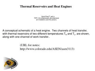
Looking at Trenton–Black River Reservoirs: Outcrops Analogs in Kentucky. Dave Harris Kentucky Geological Survey University of Kentucky. T R O U G H. R O M E. Outline. Trenton/Black River in Kentucky NYSERDA project at KGS and NYSM Tectonic dolomite examples from outcrops and shallow cores.

E N D
Looking at Trenton–Black River Reservoirs:Outcrops Analogs in Kentucky Dave Harris Kentucky Geological Survey University of Kentucky
T R O U G H R O M E
Outline • Trenton/Black River in Kentucky • NYSERDA project at KGS and NYSM • Tectonic dolomite examples from outcrops and shallow cores
Regional Structure
C h r o n o s t r a t i g r a p h i c U n i t s N o r t h G l o b a l A m e r i c a n S y s t e m S e r i e s S t a g e / S e r i e s J u n i a t a B u l l D r a k e s F m Q u e e n s t o n F o r k F m F m F m G r a n t A s h l o c k L a k e L o r r a i n e F m L i m e s t o n e G r o u p C a l l o w a y F a i r v i e w C r e e k F m / L e i p e r s F m G a r r a r d S l t s . C l a y s U t i c a F m K o p e F e r r y T r e n t o n L e x i n g t o n G r o u p L i m e s t o n e T r e n t o n L i m e s t o n e H i g h B r i d g e B l a c k R i v e r B l a c k R i v e r G r o u p G r o u p G r o u p Upper and Middle Ordovician Stratigraphy Units affected by fault-controlled dolomitization
Type Log Upper and Middle Ordovician, Central Kentucky
Shelby Co. Clark Co. Jeptha Knob
Ordovician oil shows, central Ky. Calloway Creek Fm (dolomitized),Clark Co., Ky. Lexington Ls. (Trenton)Walker Quarry, Montgomery Co., Ky.
Why look at outcrops in Kentucky? • Regional scale • Understand distribution of tectonic dolomite • Timing of faulting, dolomitization, and hydrocarbon migration • Local scale • Reservoir scale porosity and permeabilitydistribution • Depositional facies controls
Need Better Geological Model • Model for dolomitization process • Stratigraphic control on dolomite • Structural control on dolomite • Source/pathways for fluids • Timing of dolomitization • relation to hydrocarbon migration • Hydrocarbon source
NYSERDA Project • 2-year project to study central Kentucky dolomites and apply results to subsurface N.Y. dolomite reservoirs • Co-funded by Triana Energy, KGS and U.S. DOE • Focus: outcrops and new continuous cores • Approach: petrography, geochemistry, shallow high-resolution seismic, integration with New York reservoirs
NYSERDA (cont.) • Geochemical techniques • oxygen and carbon stable isotopes • microprobe (trace elements) • fluid inclusions (salinity and temperature) • Cores: 2 continuous cores through Trenton and Black River to top Knox
Integration with New York Reservoirs • Collaborating with T. Smith at the NYSM • Data to be compared with similar work on New York rocks • DOE funding shallow seismic acquisition in central Kentucky • P-wave and shear wave sources to image shallow dolomites
Tectonic Dolomite Outcrops • Hydrothermal mineralization present in central Kentucky: barite, galena, sphalerite, saddle dolomite • Upper Ordovician limestones replaced by dolomite adjacent to faults in outcrop • Black et al., (1981 USGS Professional Paper 1151A) mapped 33 T-dolomites
Ordovician Dolomite Localities Top Black River shaded relief From Black and others, 1981
Fault-controlled dolomite,Clark Co., Ky. From Black et al., 1981
Fracture-fill in core CK-15stained with alizarin-red calcite barite or celestite calcite dolomite
Shelby Co. Clark Co. Jeptha Knob
Jeptha Knob, Shelby Co., Ky. • Circular, fault-bounded structural and topographic high • About 2.5 miles in diameter, central uplift core, with flank area of annular and radial faults • Cryptoexplosive structure or meteor impact? • Ordovician limestones extensively dolomitzed
Jeptha Knob cores • Cored for mineral exploration • 3 continuous cores, from surface to about 2,000 ft • Breccias and dolomite with high-angle dips; high porosity and permeability in dolomitized Trenton • Hydrothermal? – no saddle dolomite observed
JK78-1, 341 ft JK78-1, 361 ft
High angle dips, chaotic bedding, and breccias • Skeletal grainstones and packstones (Trenton lithologies) dolomitized • Abundant moldic and intercrystalline porostiy JK78-1, 341 ft
JK78-1, 462 ft JK78-1, 409 ft
Conclusions • Fault-related, hydrothermal dolomites occur in Trenton–Black River outcrops in Kentucky • Good laboratory to develop models for hydrothermal dolomitization that will be applicable throughout the basin
Acknowledgements New York State Energy Research and Development Authority U.S. Department of Energy, National Energy Technology Laboratory Triana Energy, Inc.