Download
1 / 22
230 likes | 378 Views
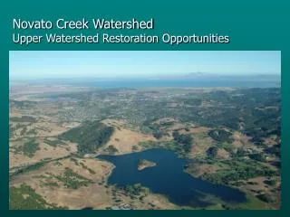
Proposed Novato Creek Bank Stabilization Guidelines. Questa Engineering Corp. Urban Bank Stabilization Problems. Privately owned creekbed Typically incising bed creating retreat of bank tops Adjacent structures need to be protected Large mature canopy trees

E N D
Proposed Novato Creek Bank Stabilization Guidelines Questa Engineering Corp.
Urban Bank Stabilization Problems • Privately owned creekbed • Typically incising bed creating retreat of bank tops • Adjacent structures need to be protected • Large mature canopy trees • Long-term Geomorphic evolutionary tendencies
Guideline Development Steps • Assess Existing Conditions • Conduct Hydraulic Analysis • Determine Long Term Trends • Define basic Creek Management Approaches • Describe suitable bank stabilization treatments • Provide permitting guidance for design and permitting of bank stabilization structures
Existing Geomorphic Conditions • Long Profile Analysis • The channel has down cut about as far it can go. Natural bedrock controls prohibit extensive vertical degradation • Bankfull Channel Dimensions • Reach 1 - 33’ top width; Max depth 3 feet • Reach 2 – 34’ top width: Max depth 3 feet • Lack of Large Woody Debris • Bedload D50 – 17 mm surface; 4.8 mm subsurface • Lateral erosion will be greatest erosion pressure in the reach
Existing Hydraulic Conditions • Bankfull flows are at threshold of erosive velocities (Max. 5 to 7 fps) • 10-year flows are above erosive velocity (Max. 9.7 to 12.1 fps) • Bank erosion episodic and is likely to occur at flows greater than bankfull, at 5 to 10 year intervals • Expect projects to be developed on a 5 to 10 year cycle
Existing Conditions Summary • Channel is near stable vertically • Lateral erosion may occur over the long-term • The channel should managed to maintain at a minimum the average top-width and bottom width
Creek Management Approaches • Fill Approach • Cut Approach • Vertical Approach
Design Approach Factors • Adjacent structure setback - 20’ distance • Presence of Trees larger than 12” DBH within 5’ of Top-of-bank • Average Channel Top-width • Average Channel Mid-width • Presence of Trees larger than 48” DBH
Bank Stabilization Design Approach Flow Chart DRAFT Existing Adjacent Structure or Utility No Yes Riparian Trees < 12”DBH Trees > 12” DBH Building Setback> 20’ Building Setback< 20’ Top Width < 65’ Single Multiple Trees < 12” DBH Cut Solution Trees > 12” DBH >48” DBH <48” DBH Top Width > 65’ Mid Width > 55’ Mid Width <55’ Top Width > 65’ Cut Solution/ Preserve Tree Cut Solution/ Lose Tree Cut Solution Cut Solution Within 10’ of TOB Fill Solution Vertical Solution or Cut Solution Max feasible Not Within 10’ of TOB Multiple Single Cut Solution Max. Feasible Mid Width > 55’ Mid Width<55’ Fill Solution Cut Solution Trees Within 10’ of TOB Trees Not Within 10’ of TOB Mid Width > 55’ Mid Width<55’ Mid Width > 55’ Mid Width <55’ Mid Width > 55’ Mid Width <55’ Cut Solution Max. Feasible Fill Solution Cut Solution Fill Solution Vertical Solution >48” DBH <48” DBH Fill Solution Cut Solution Mid Width > 55’ Mid Width <55’ Mid Width > 55’ Mid Width <55’ Cut Solution/ Preserve Tree Cut Solution/ Lose Tree Vertical Solution Fill Solution Fill Solution Cut Solution • Top Width is defined as the distance from top of bank to top of bank . • MidWidth is defined as the width at half the distance to top of bank from the channel thalweg • TOB = Top of Bank; DBH = diameter as base height (~4’ above ground) • Riparian tree is defined as any tree within 10 feet of existing top of bank • Adjacent structure/utility is a structure that is permitted through existing city ordinances or is more than 10 years old • Fences are not considered structures FIGURE 15
Approach Check Station 83925 Priority R1-2 • Structures –Shed within 20’ of TOB • Trees – one stump within 5’ of TOB • Top Width –55’ • Mid Width – 46’ • Solution Vertical or Cut max feasible
Priority R1-3 (Station 84350) • Structures –House within 20’ of TOB • Trees – multiple trees less than 12” DBH within 5’ of TOB • Top Width – 45’ • Mid Width – 30’ • Solution
Bank Stabilization Design Approach Flow Chart DRAFT Existing Adjacent Structure or Utility No Yes Riparian Trees < 12”DBH Trees > 12” DBH Building Setback> 20’ Building Setback< 20’ Top Width < 65’ Single Multiple Trees < 12” DBH Cut Solution Trees > 12” DBH >48” DBH <48” DBH Top Width > 65’ Mid Width > 55’ Mid Width <55’ Top Width > 65’ Cut Solution/ Preserve Tree Cut Solution/ Lose Tree Cut Solution Cut Solution Within 10’ of TOB Fill Solution Vertical Solution or Cut Solution Max feasible Not Within 10’ of TOB Multiple Single Cut Solution Max. Feasible Mid Width > 55’ Mid Width<55’ Fill Solution Cut Solution Trees Within 10’ of TOB Trees Not Within 10’ of TOB Mid Width > 55’ Mid Width<55’ Mid Width > 55’ Mid Width <55’ Mid Width > 55’ Mid Width <55’ Cut Solution Max. Feasible Fill Solution Cut Solution Fill Solution Vertical Solution >48” DBH <48” DBH Fill Solution Cut Solution Mid Width > 55’ Mid Width <55’ Mid Width > 55’ Mid Width <55’ Cut Solution/ Preserve Tree Cut Solution/ Lose Tree Vertical Solution Fill Solution Fill Solution Cut Solution • Top Width is defined as the distance from top of bank to top of bank . • MidWidth is defined as the width at half the distance to top of bank from the channel thalweg • TOB = Top of Bank; DBH = diameter as base height (~4’ above ground) • Riparian tree is defined as any tree within 10 feet of existing top of bank • Adjacent structure/utility is a structure that is permitted through existing city ordinances or is more than 10 years old • Fences are not considered structures FIGURE 15
Priority R2-4 (Station 91900) • Structures –within 20’ of TOB • Trees – two trees greater than 12” DBH within 5’ of TOB; none greater than 48” DBH • Top Width – 90’ • Mid Width – 40’ • Solution Vertical solution
Bank Stabilization Design Approach Flow Chart DRAFT Existing Adjacent Structure or Utility No Yes Riparian Trees < 12”DBH Trees > 12” DBH Building Setback> 20’ Building Setback< 20’ Top Width < 65’ Single Multiple Trees < 12” DBH Cut Solution Trees > 12” DBH >48” DBH <48” DBH Top Width > 65’ Mid Width > 55’ Mid Width <55’ Top Width > 65’ Cut Solution/ Preserve Tree Cut Solution/ Lose Tree Cut Solution Cut Solution Within 10’ of TOB Fill Solution Vertical Solution or Cut Solution Max feasible Not Within 10’ of TOB Multiple Single Cut Solution Max. Feasible Mid Width > 55’ Mid Width<55’ Fill Solution Cut Solution Trees Within 10’ of TOB Trees Not Within 10’ of TOB Mid Width > 55’ Mid Width<55’ Mid Width > 55’ Mid Width <55’ Mid Width > 55’ Mid Width <55’ Cut Solution Max. Feasible Fill Solution Cut Solution Fill Solution Vertical Solution >48” DBH <48” DBH Fill Solution Cut Solution Mid Width > 55’ Mid Width <55’ Mid Width > 55’ Mid Width <55’ Cut Solution/ Preserve Tree Cut Solution/ Lose Tree Vertical Solution Fill Solution Fill Solution Cut Solution • Top Width is defined as the distance from top of bank to top of bank . • MidWidth is defined as the width at half the distance to top of bank from the channel thalweg • TOB = Top of Bank; DBH = diameter as base height (~4’ above ground) • Riparian tree is defined as any tree within 10 feet of existing top of bank • Adjacent structure/utility is a structure that is permitted through existing city ordinances or is more than 10 years old • Fences are not considered structures FIGURE 15
Priority R2-6 (Station 92200) • Structures – none within 20’ of TOB • Trees – roughly 6 trees greater than 12” DBH within 5’ of TOB; none greater than 48” DBH • Top Width – 90’ • Mid Width – 56’ • Solution
Bank Stabilization Design Approach Flow Chart DRAFT Existing Adjacent Structure or Utility No Yes Riparian Trees < 12”DBH Trees > 12” DBH Building Setback> 20’ Building Setback< 20’ Top Width < 65’ Single Multiple Trees < 12” DBH Cut Solution Trees > 12” DBH >48” DBH <48” DBH Top Width > 65’ Mid Width > 55’ Mid Width <55’ Top Width > 65’ Cut Solution/ Preserve Tree Cut Solution/ Lose Tree Cut Solution Cut Solution Within 10’ of TOB Fill Solution Vertical Solution or Cut Solution Max feasible Not Within 10’ of TOB Multiple Single Cut Solution Max. Feasible Mid Width > 55’ Mid Width<55’ Fill Solution Cut Solution Trees Within 10’ of TOB Trees Not Within 10’ of TOB Mid Width > 55’ Mid Width<55’ Mid Width > 55’ Mid Width <55’ Mid Width > 55’ Mid Width <55’ Cut Solution Max. Feasible Fill Solution Cut Solution Fill Solution Vertical Solution >48” DBH <48” DBH Fill Solution Cut Solution Mid Width > 55’ Mid Width <55’ Mid Width > 55’ Mid Width <55’ Cut Solution/ Preserve Tree Cut Solution/ Lose Tree Vertical Solution Fill Solution Fill Solution Cut Solution • Top Width is defined as the distance from top of bank to top of bank . • MidWidth is defined as the width at half the distance to top of bank from the channel thalweg • TOB = Top of Bank; DBH = diameter as base height (~4’ above ground) • Riparian tree is defined as any tree within 10 feet of existing top of bank • Adjacent structure/utility is a structure that is permitted through existing city ordinances or is more than 10 years old • Fences are not considered structures FIGURE 15
Bank Stabilization Treatments Vertical Cut Fill Rock Toe-Retaining Wall Combination X X Stitch Piers X Rock Slope with Live Plantings and Rootwad Deflector X X Vegetated Earth Filled Geogrids X X X Live crib-wall X Modular Pre-cast Units X Planted Rock Revetment X X Loose Rock Revetment X X Live Staking and Willow Wattles X X Erosion Control Fabric Planted w. Rooted Trees/Shrubs X X Brush Mattress X X Fiber rolls/ fiber rock rolls/ coir erosion blankets X X X Flow deflectors/Rock Spurs X X X Log, Rootwad, and boulder revetments X X X Boulder Clusters and Rock Vortex Weirs X X X Lunker Structures X X Stabilization Treatments
Design Guidance Appendix • Design Goals and Design Requirements • Project Permitting & Approval Process • Design Steps • Existing County and City Ordinances