Download
1 / 28
280 likes | 386 Views
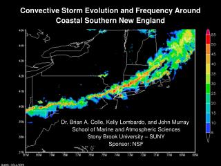
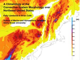
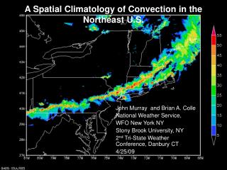
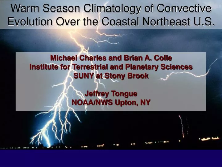
Warm Season Climatology of Convective Evolution Over the Coastal Northeast U.S. Michael Charles and Brian A. Colle Institute for Terrestrial and Planetary Sciences SUNY at Stony Brook Jeffrey Tongue NOAA/NWS Upton, NY. Forecasting Northeast coastal convection is very difficult….

E N D
Warm Season Climatology of Convective Evolution Over the Coastal Northeast U.S. Michael Charles and Brian A. Colle Institute for Terrestrial and Planetary Sciences SUNY at Stony Brook Jeffrey Tongue NOAA/NWS Upton, NY
Forecasting Northeast coastal convection is very difficult… False Alarm Rate (FAR) = Unverified warnings/total warnings (Svr tstm/torn.) ALY, BOX, OKX, and PHI from 1/1/1986 – 10/16/2003
Motivational Questions • What is the change in thunderstorm distribution in the Northeast from early to late summer? • How do thunderstorms evolve as they approach the coast? • Under what conditions does more significant convection occur at the coast even with cooler early summer SSTs?
Background • Last year’s NROW talk: • Northeast lightning climatology (2000-2002) • Concluded that a coastal gradient existed in June, but not in August. • Hypothesized that the cooler June SST’s lead to a relatively cool marine boundary layer that weakens convection approaching the coast. • This year’s research: • Included two more years (2003-2004). • Investigate the inter-annual variability in the lightning distribution – Is SST the whole story?
Sea Surface Temperatures 15 June 2000 15 August 2000
Average Lightning Distributions Terrain June 2000-2004 August 2000-2004 50 m 100 m 200 m 400 m 600 m 800 m Strikes per 100 km2 per month Strikes per 100 km2 per month
June – Sharp coastal gradient Terrain June 2000 June 2004 50 m 100 m 200 m 400 m 600 m 800 m Strikes per 100 km2 Strikes per 100 km2
June – More significant coastal lightning Terrain 50 m 100 m 200 m 400 m 600 m 800 m June 2002 June 2003 Strikes per 100 km2 Strikes per 100 km2
August – Sharp coastal gradient Terrain 50 m 100 m 200 m 400 m 600 m 800 m August 2002 August 2004 Strikes per 100 km2 Strikes per 100 km2
August – More significant coastal lightning Terrain 50 m 100 m 200 m 400 m 600 m 800 m August 2000 August 2001 Strikes per 100 km2 Strikes per 100 km2
Synoptic climatology • Cases: • Lightning cases defined as days that New Jersey, southeast New York or Connecticut received >10 lightning strikes. • Divided convection into two categories: • Near Front (Frontally maintained, referred to as frontal) • Along surface cold front (< 100 km ahead) • Less than 200 km ahead of surface warm front • Non-frontally maintained (referred to as pre-frontal) • Propagates or develops > 100 km ahead of a cold front • > 200 km ahead of a surface warm front • Both types of convection were summed into monthly totals for each year
Non-frontal: 11-12 June 2000 case storms ~100 km 00 UTC 12th NCEP sfc. analysis 00 UTC 12th OKX sounding CAPE=258 J/kg
Non-frontal: 11-12 June 2000 case Terrain 50 m 100 m 200 m 400 m 600 m 800 m 11 June 2000 Lightning Strikes (per 100 km2)
Frontal: 27-28 August 2001 storms ~100 km 00 UTC 28th NCEP sfc. analysis 00 UTC 28th OKX sounding CAPE=793 J/kg
Frontal: 27-28 August 2001 Terrain 50 m 100 m 200 m 400 m 600 m 800 m 21 August 2004 Lightning Strikes (per 100 km2)
June average lightning distribution Terrain 50 m 100 m 200 m 400 m 600 m 800 m Frontal convection Pre-frontal convection Strikes per 100 km2 per month Strikes per 100 km2 per month
August average lightning distribution Terrain 50 m 100 m 200 m 400 m 600 m 800 m Frontal convection Pre-frontal convection Strikes per 100 km2 per month Strikes per 100 km2 per month
June - Little coastal lightning 2000 2000 2004 2004
June – Significant coastal lightning 2002 2002 2003 2003
August - Little coastal lightning 2002 2002 2004 2004
August – Significant coastal lightning 2000 2000 2001 2001
Conclusions • There are large spatial gradients in lightning (convection) across the Northeast U.S. because of terrain (e.g. Wasula et al. 2002) and land-sea contrasts. • The relatively cool SST’s in the early summer can lead to rapid weakening of convection near the coast, but there is a lot of inter-annual variability. • The rapid weakening of coastal convection is favored for prefrontal (propagating) convection. Convection supported by a surface cold/warm front weakens less approaching the coast. • Those months with significant lightning near the coast have more anomalous upper-level troughing around the U.S. Eastern Seaboard.
Future Work • Convective mode: • Convection divided into two convective modes: • Organized/long-lived • Disorganized/short-lived • Determine the processes which favor more long-lived convection near the coast during warm season frontal passages. Is the convection more elevated? • Mesoscale modeling of specific cases at < 5-km grid spacing using WRF.