Download
1 / 15
150 likes | 245 Views
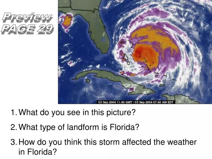
Preview PAGE 29. What do you see in this picture? What type of landform is Florida? How do you think this storm affected the weather in Florida?. L. A. M. E. C. O. W. S. Step One: Label your foldable as shown on the right Step Two:

E N D
Preview PAGE 29 • What do you see in this picture? • What type of landform is Florida? • How do you think this storm affected the weather in Florida?
L A M E C O W S Step One: Label your foldable as shown on the right Step Two: Write your name and class period on the back of your foldable.
Latitude Air Pressure MountainBarrier Elevation Continental Location Ocean Currents Wind Belts Storms
Is temperature effected by how close you live to the equator? COLDER WARM COLDER Latitude
1. Caused by unequal heating of earth’s surface 2. Low pressure = warm, moist air → rises & forms clouds → storms 3. High pressure = cold, dry air → sinks → stable and clear weather Air Pressure
Nudge Your Neighbor Nudge Your Neighbor
Elevation Elevation Increase in elevation = Decrease in temperature ↑ 1000 ft = ↓ 3.6°F COLD COOL WARM HOT
Each One, Share One… I learned …
Continental Location Continental Location Oceans are solar energy collectors because water heats & cools more slowly than land… 1. Coastline has a stable temperature 2. Interior of continent has extreme temperatures (hotter & colder). GO TO PAGE S-33 IN YOUR BOOK!
Ocean Currents Ocean Currents 1. Giant rivers of sea water flowing at surface of oceans 2. Flow in circular paths: Warm currents carry water from low → high latitudes, Cool currents return cooled water from high → low latitudes.
Doodle It Find a space in your foldable under Continental Location or Ocean Currents. Draw a new picture to represent what you have learned.
Wind Currents Wind belts “Wind” = movement of air from high pressure to low pressure (ex: poke a hole in a tire) Trade Winds: high P (30°) → low P (0°) Westerlies: high P (30°) → low P (60°) carry weather across U.S. from west → east Polar winds: → bring cold air from poles (90° → 60°)
Storms Storms Occur during low pressure conditions. Storm front = when two air masses with different temperatures meet. 1. Thunderstorms: Fronts & high pressure areas along equator 2. Tornadoes – formed along fronts 3. Tropical storms (hurricanes) – formed in oceans
One Legged Interview What does LAMECOWS mean? What elements of LAMECOWS impact Houston’s weather?