Download
1 / 72
890 likes | 1.35k Views
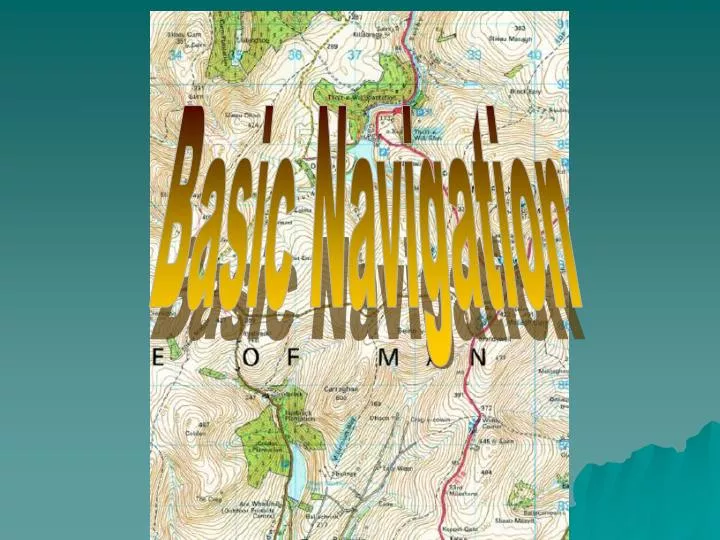
Basic Navigation. What is Navigation?. Good Navigation is knowing: Where you are on the map Where you want to go How to choose the best route to follow What is needed? Good map reading skills Good compass work. True North or Grid North?.

E N D
What is Navigation? • Good Navigation is knowing: • Where you are on the map • Where you want to go • How to choose the best route to follow • What is needed? • Good map reading skills • Good compass work
True North or Grid North? • An OS map has grid lines which enable you to identify a small area by its grid reference. • Grid lines cover a flat surface (the map) and so are regular. However, lines of longitude and latitude cover the curved surface of the earth with the lines of longitude getting closer and closer together as they reach the North and South poles.
What does this mean? Grid lines do not actually point to True North- instead they point to an imaginary point called Grid North. (The difference is insignificant and is no more than 2) • In navigation you must always use Grid North as your reference
Setting or orientating your map • Orientation of your map by eye • Turn your map in such a way that identifiable features on the ground are in their correct position relative to the map. • EASY TO PIN POINT POSITON AT ANY TIME • (It should become easier for you to see changes in direction, junctions and the appearance of features which will confirm your actual position.)
Finding North without a compass3 methods for finding north without a compass • 1. The Pole Star • In the northern Hemisphere the direction of the north pole is indicated by the position of the Pole Star. First find the Great Bear or Plough and then follow the pointers to the Pole Star
2. Using a Watch • Looking at the sun, hold your watch horizontally with the hour hand pointing at the sun. Now bisect (halve) the angle between the hour hand and the 12 o’clock position. This line points due south. In British summer time (Apr-Oct) bisect the angle between the hour and the 1 o’clock position.
3. The Shadow Method • This method can only be used if the sun is shining significantly to cast shadows. • Place a stick upright in the ground and mark the end of its shadow using a small stone. Wait for 10-15 minutes and use a second stone to mark the new position of the stick’s shadow. A straight line between the two markers runs roughly west to east.
Magnetic North • The Earth’s magnetic north pole does not coincide with its geographical north pole (true north). In the British Isles the magnetic north pole is presently about 5west of true north.
The magnetic variation as it is called is different in different parts of the world and must be allowed for when using a map and compass for navigating. To help you, the magnetic variation is always displayed on the bottom of an OS map. To further complicate things the magnetic north is not fixed and moves very slowly and changes position a little each year. This movement can be predicted and adjustments made to compensate.
The GRID MAGNETIC ANGLE (GMA) is the angular difference between the grid north and the magnetic north and is displayed on every OS map in the centre of the top margin.
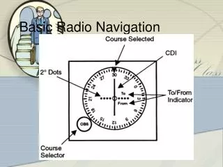
Main parts Free moving magnetic needle – half red (points North) half white (points South) Direction of travel arrow on compass plate 360 marked around the rim Orientating lines marked on its base A rotating capsule filled with a fluid to ‘damp’ the compass needle Careful not to drop and store it away from electrical appliances that contain strong magnets (e.g. TV, telephones etc..) The CompassThe Silva Compass
Magnetic Deviation Your compass needle is a small magnet and will be affected by ferrous metals placed close by. Your magnet will deviate from its true position- so take care when using your compass. Try the following:
Setting the map with a compass • Turn the compass capsule until the grid magnetic angle (GMA) is set against the direction arrow (say 6) • Place the compass onto the map so that the long edge of the compass matches the N-S grid lines and the direction of travel arrow points to the top of the map. • Turn the map and compass TOGETHER until the compass needle falls inside the orientating arrow – red end pointing North
Setting a compass heading • Compass Bearings • If you are unable to identify features to set your map you can use your compass. • (E.g. You are at GR 042 166 on the map and you are planning to walk to the church at GR 067 192)
Setting a compass heading • 1.Place the compass on the map with its long edge running through both points and the direction of travel arrow pointing in the direction you wish to travel. (You do not need to set the map for this operation) • 2. Hold the compass plate firmly in this position and turn the compass capsule until the orienting lines on its base are parallel to the north-south grid lines and the orienting arrow points to the top of the map.
3. The compass now registers the number of degrees between grid north and your intended direction of travel. Now you must add the GMA (say 6)- so turn the capsule to add another 6. 4. Remove the compass from the map and hold it in front of you so that it is level and the direction of travel arrow points away from you. Rotate your body until the magnetic needle falls within the orienting arrow on the base of the capsule- red end pointing north. Setting a compass heading
Setting a compass heading • 5. The direction of travel arrow should now point in the direction you need to walk. • REMEMBER GRID to MAG - ADD
Always choose a feature in the far distance- possibly on the horizon, and walk to that – Avoid walking while staring at your compass! If it is poor visibility- sight on an object at the limit of you visibility, a rock, a bunch of reeds. As you approach your chosen object, others will appear behind it and in line with it. Use these continually appearing objects to do your straight line compass march. Walking on a bearing
Transferring from compass to map • You can take a compass bearing and convert it to a map bearing in order to identify a feature or to help pinpoint your position. • (E.g. You are on the path at GR 051 179 and you see a church in the distance that you want to identify on the map)
Transferring from compass to map • 1. Point the direction of travel arrow at the distant church. • 2. Hold the compass in this position and turn the capsule until the orienting arrow lies directly beneath the north end of the compass needle. This gives the magnetic bearing. • 3. Now turn the capsule to deduct the GMA (6). This now gives the grid bearing.
4. Place the compass on the map (you do not have to set the map) with its long edge passing through your present position, on the path at GR 051 179. DO NOT TURN the capsule. • 5. Pivot the whole compass around your position until the orienting lines are parallel to the north-south grid lines and the orienting arrow points to north on the map
Transferring from compass to map • The edge of the compass that runs through your position should now run through, or point at, the symbol for a church you can see in the distance. • REMEMBER MAG to GRID – get RID
Resection – Finding where you are • If you have a vague idea where you are on a map and wish to determine your position more accurately • You must be able to identify at least 3 features on the ground around you (i.e. the edge of a wood, a church and a hill)
Resection – Finding where you are • Take each feature in turn, take its compass bearing, convert it to a grid bearing and plot its position on the map. • Draw a faint pencil line along the long edge of your compass so that it passes through the known feature. • Repeat this for the two other features and the point where all 3 lines cross marks your position. (The lines rarely meet at a point; take position as being near the centre of the triangle formed.)
Using a Roamer- A Roamer is used to find a 6 figure grid reference more accurately than by estimation. You must have the correct roamer scale for the map Scales and Roamers
Place the corner of the correct roamer on the map feature whose reference you want, then read from where the scales intersect the grid lines. • Always read the nearest low figure (SW corner)
Use dividers-Measure distance between two features on the map by opening the dividers to touch each feature and then transfer this measurement onto the scale at the bottom of the map. DO NOT PUNTURE THE MAP! Straight Edge of Paper- Place the piece of paper between the features on the map and mark their position on the paper. Now line this up with the scale at the bottom of the map. By placing your paper on the scale so that the right hand mark is on a whole number of units, the second mark should fall on the tenths to the left of the zero. Measuring distances on a map
Practical Navigation • Measuring distance on the ground • There are two ways to estimate distance: • Timing b) Pacing
a)Timing – How long does it take you to walk 1 km? • If you know how fast you walk, then you should be able to work out how long it will take you to cover a known distance. • Speed =distance / time Therefore • time = distance / speed • E.g. If you need to walk 2 km and you can walk at 4 km/h. How long will it take you? • Time = 2 km / 4 km/h = 0.5 h or ½ hour
Going Uphill – Naismuth’s rule Add ½ hour for every 200 m of climbing Going downhill – extra timing for climbing usually cancels with faster walking on descents. However, very steep descents may require more care. In this case: Add 10 minutes for every 200m in steep descent Things to consider
Fitness – A group can only move at the speed of the slowest member. Terrain – It is not always possible to tell from a map just how rough the terrain will be. Marshes, boulder fields and forest can all slow walkers down. Unsure of Terrain – Allow for slow progress Load – Carrying a heavy pack can slow a walker by as much as 50% of normal speed. Heavy Load – Reduce overall speed to 3 km/h or even 2 km/h Things to consider
Pacing • Counting paces – This involves counting paces over short distances only. • -Count number of double paces (each time the same foot hits the ground) • -Different terrain will require adjustments
Errors Try to be as accurate as possible – errors in both distance and direction could result in huge uncertainties after only short distances. • Error of ± 10% for distance • Error of ± 4 for direction • RESULT – Huge AREA of uncertainty
After 1 km uncertainty 4 football pitches • After 3 km uncertainty 36 football pitches!!! • Keep the legs of your route as short a possible • Practice compass work • Practice Pacing and timing distances
Good Navigational Techniques • 1. Handrailing- This technique uses easy to follow linear features to direct you to your final destination. The linear feature is used as a ‘handrail’. • Use ‘handrailing’ to get you from position A to the camp site.
Good Navigational Techniques • 2. Aiming off- Imagine you are at point A and you want to cross the river at the bridge. • Aiming directly for the bridge – chances are that you would miss it, and you would not know to turn upstream or downstream to look for the bridge. • Aiming off slightly to one side- you would then know which way to turn when you hit the stream.
Good Navigational Techniques • 3. Contouring • Is it better to go round a hill or up over the top? • The two routes may take the same time, but contouring round takes less effort. • To consider- • Contouring requires very careful navigation, particularly in poor visibility (tendency to lose height and to travel too far around the curve)
Good Navigational Techniques • Try this: • The route around the spur is 4 km and will take you about 1 hour to walk. • The route over the hill is only 2 km long but you have to climb 200m • Use Naisth’s rule, how long would this route take to walk?